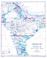
Category:Maps of India
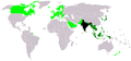
Countries of Asia: Afghanistan · Armenia‡ · Azerbaijan‡ · Bahrain · Bangladesh · Bhutan · Brunei · Cambodia · People's Republic of China · Cyprus‡ · East Timor · Egypt‡ · Georgia‡ · India · Indonesia‡ · Iran · Iraq · Israel · Japan · Jordan · Kazakhstan‡ · Kuwait · Kyrgyzstan · Laos · Lebanon · Malaysia · Maldives · Mongolia · Myanmar · Nepal · North Korea · Oman · Pakistan · Philippines · Qatar · Russia‡ · Saudi Arabia · Singapore · South Korea · Sri Lanka · Syria · Tajikistan · Thailand · Turkey‡ · Turkmenistan · United Arab Emirates · Uzbekistan · Vietnam · Yemen
Limited recognition: Abkhazia‡ · Taiwan · Northern Cyprus‡ · State of Palestine · South Ossetia‡ – Other territories: Akrotiri and Dhekelia‡ · British Indian Ocean Territory · Hong Kong · Macau
‡: partly located in Asia
Limited recognition: Abkhazia‡ · Taiwan · Northern Cyprus‡ · State of Palestine · South Ossetia‡ – Other territories: Akrotiri and Dhekelia‡ · British Indian Ocean Territory · Hong Kong · Macau
‡: partly located in Asia
Wikimedia category | |||||
| Upload media | |||||
| Instance of | |||||
|---|---|---|---|---|---|
| Category combines topics | |||||
 | |||||

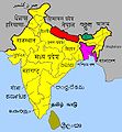
States of India: Andhra Pradesh · Arunachal Pradesh · Assam · Bihar · Chhattisgarh · Goa · Gujarat · Haryana · Himachal Pradesh · Jharkhand · Karnataka · Kerala · Madhya Pradesh · Maharashtra · Manipur · Meghalaya · Mizoram · Nagaland · Odisha · Punjab · Rajasthan · Sikkim · Tamil Nadu · Telangana · Tripura · Uttar Pradesh · Uttarakhand · West Bengal
Union territories: Andaman and Nicobar Islands · Chandigarh · Dadra and Nagar Haveli and Daman and Diu · Delhi · Jammu and Kashmir · Ladakh · Lakshadweep · Puducherry
Former states of India: Jammu and Kashmir ·
Former union territories: Dadra and Nagar Haveli district · Daman and Diu ·
Union territories: Andaman and Nicobar Islands · Chandigarh · Dadra and Nagar Haveli and Daman and Diu · Delhi · Jammu and Kashmir · Ladakh · Lakshadweep · Puducherry
Former states of India: Jammu and Kashmir ·
Former union territories: Dadra and Nagar Haveli district · Daman and Diu ·
Subcategories
This category has the following 29 subcategories, out of 29 total.
!
*
A
- Atlas of India (1827-1906) (209 F)
B
C
E
- ECHO Daily Maps of India (62 F)
F
I
M
- Maps of India (low quality) (21 F)
P
S
U
- Unidentified maps of India (53 F)
W
- WikiProject India/Maps (15 F)
Media in category "Maps of India"
The following 170 files are in this category, out of 170 total.
-
 "Jammu and Kashmir, India Locator map".png 1,574 × 1,738; 723 KB
-
 -File-India GSDP updated.png 800 × 911; 117 KB
-
 107.35149E 34.75769N.png 1,028 × 726; 1.03 MB
-
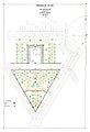
 11 Industrial Corridors.jpg 958 × 1,101; 151 KB
-
 14 Ochomiles.png 4,480 × 2,472; 10.45 MB
-
 1574247251 Srisailam Dam.jpg 297 × 300; 22 KB
-
 2015.01.31 wikiatlas dasharray mess 8,4 mesh Chrome.png 499 × 493; 40 KB
-
 2015.01.31 wikiatlas dasharray mess 8,4 mesh FF.png 501 × 491; 52 KB
-
 7000 ACRES LOHGARH.jpg 8,400 × 8,900; 16.68 MB
-
 A map showing destnations served by Patna airport.gif 540 × 540; 17 KB
-
 A@12345.jpg 1,747 × 1,389; 1,006 KB
-
 Adan nil.jpg 3,508 × 2,480; 571 KB
-
 Adil Shahis.png 2,324 × 2,151; 7.44 MB
-
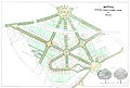
 Agra park plan Griessen.jpg 2,112 × 3,008; 2.73 MB
-
 Alexander's Indian route.jpg 1,169 × 1,074; 168 KB
-
 Allied Third Burma Campaign Apri 1-May 1945.jpg 1,260 × 970; 270 KB
-
 Ancient India, 2000 B.C.-800 A.D. - page 73.png 1,803 × 1,339; 613 KB
-
 Aparanta.jpg 540 × 595; 30 KB
-
 Asoka̠ Buddhist Missions.png 1,252 × 1,284; 469 KB
-
 Bagals subdivision.png 1,280 × 1,280; 1.97 MB
-
 Barpelhadih location.jpg 167 × 256; 19 KB
-
 Bhadradri Kothagudem.png 1,231 × 896; 817 KB
-
 Brahmadesam(Tindivanam) Location map.jpg 1,177 × 930; 245 KB
-
 Buhana.jpg 304 × 238; 52 KB
-
 Buldana Urban - Working Area.JPG 600 × 673; 39 KB
-
 Campus Karma User Hits Distribution In India.png 880 × 547; 112 KB
-
 Cattle plague map.jpg 4,334 × 3,888; 9.7 MB
-
 Centres of Activities for Satellite Instructional Television Experiment in India.png 1,473 × 1,086; 1.16 MB
-
 Coastal India.jpg 511 × 325; 20 KB
-
 Coastal South West India.jpg 512 × 324; 19 KB
-
 Dogra conquests.png 850 × 752; 84 KB
-
 Dravidianlanguages.jpg 1,456 × 1,756; 520 KB
-
 Drive-by survey mapping of filling stations.png 1,354 × 789; 801 KB
-
 East Coast Economic Corridor and Proposed Industrial Nodes.jpg 930 × 701; 210 KB
-
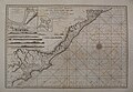
 East Indies Roads 1768.jpg 16,642 × 13,088; 40.98 MB
-
 ECDM 20210525 TC YAAS.pdf 2,479 × 1,754; 1.35 MB
-
 ECDM 20211005 TC GULAB.pdf 2,481 × 1,754; 796 KB
-
 ECDM 20211022 India-Nepal.pdf 2,479 × 1,754; 1.48 MB
-
 EeV6BF8UEAAJTvZ.png 1,280 × 720; 1.73 MB
-
 Eight Thousanders Map.png 1,121 × 794; 161 KB
-
 Eparchy of Shamshabad.jpg 567 × 960; 64 KB
-
 Epicindia2caps1.png 1,002 × 1,176; 1.49 MB
-
 Ethnobotany of India V1.png 990 × 1,056; 412 KB
-
 Famine Map India.jpg 3,169 × 4,400; 8.02 MB
-
 Field stations under DPPQ&S.jpg 887 × 597; 46 KB
-
 Field Stations Under Dte. of P.P.Q.&S. Map.png 714 × 492; 196 KB
-
 FLII India.png 844 × 796; 145 KB
-
 Foucher - La Vie du Bouddha, 1949 - Figure 2.svg 430 × 240; 354 KB
-

-

-
 Geographical distribution of Muslim Tyagi.pdf 1,754 × 1,239; 1.38 MB
-
 Geopolitical map of Bagals.png 1,992 × 2,470; 2.33 MB
-
 Gondwana Kingdom edited.jpg 720 × 720; 373 KB
-
 GondWana Under Sangram Shah.jpg 720 × 720; 353 KB
-
 Gurudwara garden Delhi Griessen.jpg 2,188 × 3,200; 2.85 MB
-
 Hindistan Dilleri.jpg 640 × 691; 61 KB
-
 Icmai regional council.jpg 1,062 × 1,280; 84 KB
-
 Important Jain Pilgrimage Sites on Map of India 2.jpg 3,456 × 4,608; 6.87 MB
-
 Important Jain Pilgrimage Sites on Map of India.jpg 3,456 × 4,608; 6.87 MB
-
 India Directional Divisions.png 3,818 × 4,600; 1.04 MB
-
 India districtmap bhoyari betul.png 1,643 × 1,856; 768 KB
-
 India FTA.png 1,357 × 628; 47 KB
-
 India GDP real yoy rate, quarterly.png 1,200 × 1,000; 64 KB
-
 India in 477 CE.png 749 × 946; 1.03 MB
-
 India map 2.jpg 738 × 1,600; 75 KB
-
 India map km.jpg 581 × 595; 34 KB
-
 India Map Urdu.jpg 2,000 × 1,801; 350 KB
-
 India Map..jpg 1,594 × 1,868; 182 KB
-
 INDIA'S CLIMATIC CONDITIONS.png 2,000 × 2,260; 909 KB
-
 India-Industrial Clusters.png 2,541 × 2,382; 247 KB
-
 India-NH45-Tamil.jpg 767 × 466; 81 KB
-
 Indian nationalism.jpg 3,342 × 3,224; 411 KB
-
 Indian Rivers Inter-link.png 612 × 600; 347 KB
-
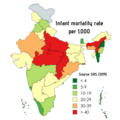 Indian states by IMR.png 1,080 × 1,080; 235 KB
-
 Irrigation map India 1879.png 1,876 × 2,325; 3.38 MB
-
 Islam In India.png 2,000 × 2,208; 871 KB
-
 Jalippm.png 493 × 593; 223 KB
-
 Jangaon map.PNG 1,185 × 528; 819 KB
-
 Jangaon.png 1,231 × 896; 715 KB
-
 Jaya-Shankar.jpg 4,960 × 3,508; 2.42 MB
-
 Jma-map.jpg 600 × 624; 111 KB
-
 Jmamap123.jpg 600 × 624; 75 KB
-
 Jodhpur tehsil.jpg 1,231 × 1,080; 180 KB
-
 Kalpsar2.jpg 819 × 555; 135 KB
-
 Kingdom of Jammu & kashmir.jpg 640 × 451; 53 KB
-
 KNN Operating Architecture.jpg 2,484 × 3,511; 1.19 MB
-
 Kodungallur-municipality.png 26,400 × 17,700; 9.46 MB
-
 Koshti people in India.jpg 446 × 371; 70 KB
-
 Lambton Everest C India.jpg 1,665 × 1,712; 1.55 MB
-

-
 Location map India Mizoram Districts EN.svg 266 × 572; 38 KB
-
 Location of Dantewada.jpg 3,507 × 2,457; 614 KB
-
 M17663.pdf 1,539 × 1,162; 1.6 MB
-
 Magadh State.png 1,638 × 1,852; 344 KB
-
 Maharashtra UPA Seat Sharing Modified.png 1,280 × 846; 229 KB
-
 Maharashtra UPA Seat Sharing.png 1,280 × 846; 229 KB
-
 Main-qimg-d6e222706bcf39eb7207c9ce883967f5.webp 400 × 337; 9 KB
-
 Major Sino-Tibetan groups.png 471 × 414; 16 KB
-
 Map of Bangalore Metropolitan Region.png 600 × 800; 29 KB
-
 Map of Chetpet Lake.png 916 × 779; 128 KB
-
 Map of the Cahamanas.png 2,324 × 2,151; 6.58 MB
-
 Map of the Candellas.png 2,324 × 2,151; 6.49 MB
-
 Map of the Chachas circa 650 CE.png 2,324 × 2,151; 6.98 MB
-
 Map of the Eastern Gangas.png 2,324 × 2,151; 7.06 MB
-
 Map of the Kakatiyas.png 2,324 × 2,151; 6.94 MB
-
 Map of the Later Kalacuris.png 2,324 × 2,151; 6.72 MB
-
 Map of the Maha-Meghavahanas.png 2,324 × 2,151; 7.25 MB
-
 Map of the Maukharis.png 2,324 × 2,151; 7.06 MB
-

-
 Maps towards aurangzebs Deccan Campaign.jpg 2,289 × 1,288; 353 KB
-
 Mathura plan Griessen.jpg 4,448 × 3,008; 7.29 MB
-
 Mean Wind Speed Map India.png 3,308 × 2,339; 2.36 MB
-
 Mekala region.png 514 × 600; 68 KB
-
 Mithila region of India (Eng).jpg 1,996 × 1,858; 434 KB
-
 Mithila Region on India Map.png 1,638 × 1,852; 353 KB
-
 Mizo diaspora map by Jokomarel.png 6,460 × 3,403; 2.43 MB
-
 Modern Bengal map.png 656 × 599; 108 KB
-
 MtKailash location.png 980 × 615; 964 KB
-
 Muslim Population in India.png 2,000 × 2,208; 871 KB
-
 N 20, E 75 - N 30, E 90 slope map.png 10,275 × 7,721; 35.92 MB
-
 Nalanda layout 1b.JPG 351 × 625; 33 KB
-
 Nepenthes khasiana distribution.gif 515 × 601; 26 KB
-
 NJ-44-13 Kang-Hsi-Wa China.jpg 8,544 × 6,583; 10.54 MB
-
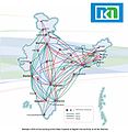 Nkn topology.jpg 701 × 720; 83 KB
-
 NO2 concentrations over India.jpg 1,322 × 1,050; 797 KB
-
 Northern circars.jpg 1,280 × 881; 383 KB
-
 Odisha 1592.jpg 562 × 607; 69 KB
-
 P 20160604 131934 DF.jpg 2,304 × 4,096; 1.24 MB
-
 PacificTheaterAug1942.jpg 1,199 × 873; 256 KB
-
 Pamaria Map.jpg 1,540 × 1,164; 308 KB
-
 Pantholops hodgsonii distribution bw.png 1,259 × 944; 1.84 MB
-
 Pantholops hodgsonii distribution.png 1,259 × 944; 2.49 MB
-
 Partition of India.jpg 370 × 338; 64 KB
-
 PAT - India.gif 970 × 1,060; 357 KB
-
 Patni Global Presence May '10 Final.jpg 954 × 570; 78 KB
-
 Pauravas.png 1,354 × 592; 178 KB
-
 Percent of scheduled tribes in India by tehsils by census 2011.png 4,280 × 4,688; 2.38 MB
-
 Percent of scheduled tribes in India-tehsils-census 2011.svg 2,268 × 2,201; 7.1 MB
-
 Peshwa dyansty.jpg 453 × 422; 58 KB
-
 Physical Map of India.jpg 4,724 × 4,960; 7.68 MB
-
 Political Map of India.jpg 1,958 × 2,070; 208 KB
-
 Population density of India states and union territories.png 3,349 × 3,902; 668 KB
-
 Propsed states of India with Mithila Telangana.png 1,638 × 1,852; 414 KB
-
 Pukhrayan accident.jpg 913 × 1,104; 117 KB
-
 River Systems in India with Terrain June 2014.png 3,111 × 3,902; 12.78 MB
-
 Route Of Ghimire Ancestor Gudpal From Ujjain to Ghamir.PNG 371 × 341; 283 KB
-
 RV elterjedés.jpg 669 × 602; 70 KB
-
 S India slope map.png 9,477 × 6,990; 19.46 MB
-
 Sathopur.jpg 591 × 415; 87 KB
-
 SEZ in India.jpg 634 × 753; 98 KB
-
 ShimlaKinnaurRoute map in Bengali.png 745 × 1,053; 56 KB
-
 State and union territory-level parties.png 1,350 × 899; 89 KB
-
 Tagawali in Dholpur district-map.jpg 600 × 427; 65 KB
-
 Tensions-between-india-and-china.jpg 960 × 585; 151 KB
-
 The 12 Jyotirlingas-Map.jpg 509 × 609; 65 KB
-
 The Red Corridor ver 1.PNG 530 × 599; 146 KB
-
-
 Tripartite Struggle.png 2,549 × 2,880; 1.17 MB
-
 Txu-pclmaps-oclc-22834566 h-10a.jpg 9,264 × 6,761; 17.79 MB
-
 USA-CBI-Time-1.jpg 1,800 × 1,978; 342 KB
-
 Wikimedia Education SAARC Conference Participants Map.png 3,543 × 3,543; 1.01 MB
-
 Wo-de-india-map.png 524 × 612; 16 KB
-
 Zirapur.gif 1,533 × 2,172; 1.56 MB
-
 Паліян.jpg 425 × 321; 23 KB
-
 Уладан.jpg 425 × 321; 24 KB
-
 ہندوستان1760.png 3,440 × 4,072; 1.36 MB
-
 बदमि एम्पिरे.png 516 × 599; 72 KB
-
 भारत.jpg 1,081 × 1,306; 142 KB
-
 सिद्धनाथ मंदिर स्थान.jpg 1,080 × 1,152; 595 KB
-
 卡西丘陵.jpg 2,326 × 1,523; 423 KB


_Location_map.jpg)


.jpg)


.jpg)


,_Department_of_Science_%26_Technology,_in_Kolkata.jpg)


