Category:Maps of Johor
Bahasa Melayu: Peta Johor
Wikimedia category | |||||
| Upload media | |||||
| Instance of | |||||
|---|---|---|---|---|---|
| Category combines topics | |||||
| Johor | |||||
Malaysian state       | |||||
| Instance of | |||||
| Location | MYS | ||||
| Located in or next to body of water |
| ||||
| Capital | |||||
| Official language | |||||
| Anthem |
| ||||
| Currency | |||||
| Head of government | |||||
| Significant event |
| ||||
| Population |
| ||||
| Area |
| ||||
| Elevation above sea level |
| ||||
| official website | |||||
 | |||||
Subcategories
This category has the following 4 subcategories, out of 4 total.
E
- Election maps of Johor (25 F)
J
- Maps of Johor Bahru (5 F)
O
- Old maps of Johor (7 F)
S
- SVG maps of Johor (56 F)
Media in category "Maps of Johor"
The following 19 files are in this category, out of 19 total.
-
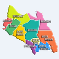 Districts of Johor.PNG 573 × 573; 979 KB
-
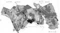
 IMBRT.png 2,117 × 1,855; 5.07 MB
-
 JHB routes (final).PNG 1,455 × 1,750; 469 KB
-
 Malaysia Regions Johor.png 786 × 286; 50 KB
-
 Johor Bahru Conurbation.png 833 × 458; 292 KB
-
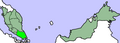
 Johor state locator.PNG 3,000 × 1,025; 118 KB
-
 Ledang District.jpg 328 × 301; 88 KB
-
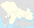
 Location map of Iskandar Puteri, Johor.png 668 × 555; 24 KB
-
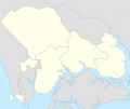
 Location map of Johor Bahru, Johor.png 668 × 555; 24 KB
-
 MalaysiaJohor.png 400 × 144; 16 KB
-
 Map of Iskandar Malaysia municipal governments.png 499 × 414; 31 KB
-
 Map of Iskandar Malaysia's local governments.png 500 × 426; 24 KB
-
 Map of Iskandar Malaysia's municipal governments.png 499 × 422; 24 KB
-
 MapMalaysiaJohorBahru.png 400 × 144; 29 KB
-
 Mount Ophir info.jpg 2,048 × 1,536; 661 KB
-
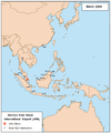
 Raffles Banded Surili area.png 129 × 165; 2 KB
-
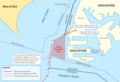 Tuas dispute.png 1,500 × 1,020; 298 KB
-
 Tuas maritime dispute.png 1,500 × 1,020; 351 KB
-
 古來市位置圖.jpg 2,508 × 2,822; 1.3 MB


.PNG)


