Category:Maps of La Loge-aux-Chèvres
Wikimedia category | |||||
| Upload media | |||||
| Instance of | |||||
|---|---|---|---|---|---|
| Category combines topics | |||||
| La Loge-aux-Chèvres | |||||
commune in Aube, France  Церковь Сент-Антуан  | |||||
| Instance of | |||||
| Located in protected area | |||||
| Location | |||||
| Population |
| ||||
| Area |
| ||||
 | |||||
Media in category "Maps of La Loge-aux-Chèvres"
The following 3 files are in this category, out of 3 total.
-
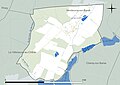 10200-La Loge-aux-Chèvres-Hydro.jpeg 5,846 × 4,133; 974 KB
-
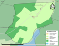 10200-La Loge-aux-Chèvres-Sols.png 3,270 × 2,598; 639 KB
-
 Map commune FR insee code 10200.png 756 × 605; 11 KB

