Category:Maps of Nestier
Wikimedia category | |||||
| Upload media | |||||
| Instance of | |||||
|---|---|---|---|---|---|
| Category combines topics | |||||
| Nestier | |||||
commune in Hautes-Pyrénées, France  .svg)  | |||||
| Instance of | |||||
| Location |
| ||||
| Population |
| ||||
| Area |
| ||||
| Elevation above sea level |
| ||||
 | |||||
Subcategories
This category has the following 7 subcategories, out of 7 total.
C
- Cadastral maps of Nestier (3 F)
E
- Ecological maps of Nestier (3 F)
H
- Hydrographic maps of Nestier (2 F)
O
- Old maps of Nestier (8 F)
T
- Topographic maps of Nestier (3 F)
- Touristic maps of Nestier (2 F)
Media in category "Maps of Nestier"
The following 7 files are in this category, out of 7 total.
-
 65327-Nestier - Localisation.png 2,000 × 2,480; 1.04 MB
-
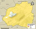 65327-Nestier-argile.jpg 3,057 × 2,480; 431 KB
-
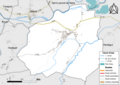 65327-Nestier-Hydro.png 7,015 × 4,960; 3.13 MB
-
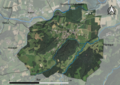 65327-Nestier-Orthophoto.png 7,015 × 4,960; 4.39 MB
-
 65327-Nestier-Sols.png 7,015 × 4,960; 3.3 MB
-
 Map commune FR insee code 65327.png 756 × 605; 33 KB
-
 Plan "Eth Castet".jpg 2,480 × 3,507; 779 KB


