Category:Maps of Oriolles
Wikimedia category | |||||
| Upload media | |||||
| Instance of | |||||
|---|---|---|---|---|---|
| Category combines topics | |||||
| Oriolles | |||||
commune in Charente, France   | |||||
| Instance of | |||||
| Location |
| ||||
| Population |
| ||||
| Area |
| ||||
 | |||||
Media in category "Maps of Oriolles"
The following 5 files are in this category, out of 5 total.
-
 16251-Oriolles-argile.jpg 3,057 × 2,480; 606 KB
-
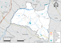 16251-Oriolles-Routes-Hydro.png 3,507 × 2,480; 1.75 MB
-
 16251-Oriolles-Routes-Hydro.svg 1,056 × 744; 2.85 MB
-
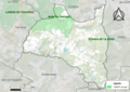 16251-Oriolles-ZNIEFF1.png 5,866 × 4,133; 8.5 MB
-
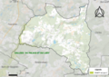 16251-Oriolles-ZNIEFF2.png 5,866 × 4,133; 8.52 MB


