Category:Maps of Saint-Jean (Haute-Garonne)
Wikimedia category | |||||
| Upload media | |||||
| Instance of | |||||
|---|---|---|---|---|---|
| Category combines topics | |||||
| Saint-Jean | |||||
commune in Haute-Garonne, France _-_Eglise.jpg) .svg)  | |||||
| Instance of | |||||
| Location |
| ||||
| Population |
| ||||
| Area |
| ||||
| Elevation above sea level |
| ||||
| official website | |||||
 | |||||
Media in category "Maps of Saint-Jean (Haute-Garonne)"
The following 12 files are in this category, out of 12 total.
-
 31488-Saint-Jean-argile.jpg 3,057 × 2,480; 585 KB
-
 31488-Saint-Jean-Natura2000.png 7,015 × 4,960; 16.63 MB
-
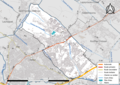 31488-Saint-Jean-Routes-Hydro.png 3,507 × 2,480; 6.29 MB
-
 31488-Saint-Jean-Sols.png 7,015 × 4,960; 15.81 MB
-
 31488-Saint-Jean-ZNIEFF1.png 3,519 × 2,480; 3.1 MB
-
 31488-Saint-Jean-ZNIEFF2.png 3,519 × 2,480; 7.58 MB
-
 Cadastre de Saint-Jean - Section C, 1ère feuille, éch. 1-2500..jpg 6,233 × 4,335; 4.13 MB
-
 Cadastre de Saint-Jean - Section C, 2ème feuille, éch. 1-2500..jpg 5,899 × 4,503; 4.87 MB
-
 Cadastre de Saint-Jean - Section D, 1ère feuille, éch. 1-2500..jpg 6,320 × 4,327; 4.66 MB
-
 Cadastre de Saint-Jean - Section D, 2ème feuille, éch. 1-2500..jpg 6,032 × 4,135; 4.36 MB
-
 Cadastre de Saint-Jean - Tableau d'assemblage, éch. 1-10000..jpg 6,263 × 4,325; 4.29 MB
-
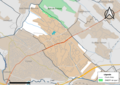
 Map commune FR insee code 31488.png 756 × 605; 62 KB


