Category:Maps of Salem, Massachusetts
Wikimedia category | |||||
| Upload media | |||||
| Instance of | |||||
|---|---|---|---|---|---|
| Category combines topics | |||||
| Salem | |||||
city in Massachusetts, United States     | |||||
| Instance of | |||||
| Part of | |||||
| Location | Essex County, Massachusetts | ||||
| Head of government |
| ||||
| Inception |
| ||||
| Significant event | |||||
| Population |
| ||||
| Area |
| ||||
| Elevation above sea level |
| ||||
| Different from | |||||
| official website | |||||
 | |||||
Subcategories
This category has the following 4 subcategories, out of 4 total.
1
- 1916 City of Salem (2 F)
M
- Maps of Salem Harbor (5 F)
Media in category "Maps of Salem, Massachusetts"
The following 20 files are in this category, out of 20 total.
-
 1692 Salem Massachusetts map BPL 12894.png 918 × 747; 1.19 MB
-
 1883 bird's eye view map of Salem, Massachusetts.jpg 11,304 × 6,978; 15.29 MB
-
 1903 Map of Salem and surrounding places (7557369652).jpg 7,605 × 5,602; 41.1 MB
-

-

-
 Admiralty Chart No 2427 Massachusetts Salem Harbour, Published 1867.jpg 8,083 × 6,002; 7.02 MB
-
 Chart of the harbours of Salem, Marblehead, Beverly and Manchester (2674399553).jpg 2,000 × 1,606; 2.75 MB
-
 Chart of the harbours of Salem, Marblehead, Beverly, and Manchester (2675217164).jpg 2,000 × 1,452; 2.41 MB
-

-
 Map of Salem Village 1692 (3719859897).jpg 1,024 × 618; 534 KB
-
 Map of Salem Village.jpg 2,592 × 1,830; 1.06 MB
-
 Map of Salem, Mass. (6093647937).jpg 2,000 × 1,284; 2 MB
-
 Map of the city of Salem, Mass. (7557390952).jpg 6,502 × 6,674; 39.39 MB
-
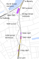 Salem downtown stations map.svg 1,200 × 1,800; 51 KB
-
 Salem ma highlight.png 788 × 466; 54 KB
-
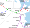 Salem stations and lines map.svg 800 × 750; 44 KB
-
 Signage at Salem station (11), December 2018.jpg 5,472 × 3,648; 6.17 MB
-
 Signage at Salem station (13), December 2018.jpg 5,472 × 3,648; 5.23 MB
-
 Signage at Salem station (15), December 2018.jpg 5,472 × 3,648; 5.05 MB
-
 Signage at Salem station (16), December 2018.jpg 5,472 × 3,648; 4.07 MB


.jpg)
.jpg)
_-_Essex_County_-_Salem_-_ED_5-369_to_429,_5-480_-_NARA_-_12171747.jpg)

.jpg)
.jpg)

.jpg)

.jpg)
.jpg)


,_December_2018.jpg)
,_December_2018.jpg)
,_December_2018.jpg)
,_December_2018.jpg)