Category:Maps of Sandusky County, Ohio
Wikimedia category | |||||
| Upload media | |||||
| Instance of | |||||
|---|---|---|---|---|---|
| Category combines topics | |||||
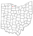
| Sandusky County | |||||
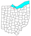
county in Ohio, United States    | |||||
| Instance of | |||||
| Location | Ohio | ||||
| Capital | |||||
| Inception |
| ||||
| Population |
| ||||
| Area |
| ||||
| Different from | |||||
| official website | |||||
 | |||||
Sandusky County is in Ohio in the United States. Its county seat is Fremont.
Subcategories
This category has the following 3 subcategories, out of 3 total.
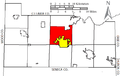
Media in category "Maps of Sandusky County, Ohio"
The following 38 files are in this category, out of 38 total.
-
 1888 Map of Lucas and parts of Wood, Ottawa and Sandusky Counties, Ohio.jpg 17,370 × 11,606; 42.59 MB
-
 Annual report of the Ohio State Academy of Science (1903) (19365391075).jpg 3,240 × 2,016; 473 KB
-
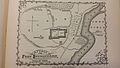
 Battle of Fort Stephenson from 1912 History Book.png 927 × 623; 149 KB
-
 Bellevue, Ohio, Sandusky & Huron counties 1888. LOC 75694913.jpg 9,384 × 5,608; 11.09 MB
-
 Detailed map of Elmore, Ohio.png 575 × 425; 38 KB
-
 Fort Stephenson.jpg 5,312 × 2,988; 4.82 MB
-
 Fostoria Ohio Railroad Map 1880.jpg 624 × 361; 64 KB
-
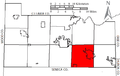 Green Creek Twp Sandusky OH.PNG 659 × 419; 21 KB
-
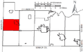
 Jackson Twp Sandusky OH.PNG 659 × 419; 21 KB
-
 Madison Twp Sandusky OH.PNG 659 × 419; 21 KB
-
 Map of Ohio highlighting Sandusky County.svg 3,675 × 3,995; 58 KB
-
 Map of Sandusky County, Ohio. LOC 2012592237.jpg 18,731 × 12,470; 30.45 MB
-
 Map of Sandusky County, Ohio. LOC 2012592237.tif 18,731 × 12,470; 668.27 MB
-
 Maumee Road Lands.png 936 × 543; 372 KB
-
 OHMap-doton-Ballville.png 274 × 300; 10 KB
-
 OHMap-doton-Bellevue.png 274 × 300; 10 KB
-
 OHMap-doton-Burgoon.png 274 × 300; 10 KB
-
 OHMap-doton-Clyde.png 274 × 300; 10 KB
-
 OHMap-doton-Elmore.png 274 × 300; 10 KB
-
 OHMap-doton-Fremont.png 274 × 300; 10 KB
-
 OHMap-doton-Gibsonburg.png 274 × 300; 10 KB
-
 OHMap-doton-Green Springs.png 274 × 300; 10 KB
-
 OHMap-doton-Helena.png 274 × 300; 10 KB
-
 OHMap-doton-Lindsey.png 274 × 300; 10 KB
-
 OHMap-doton-Millersville.png 309 × 352; 17 KB
-
 OHMap-doton-Stony Prairie.png 274 × 300; 10 KB
-
 OHMap-doton-Vickery.png 309 × 352; 17 KB
-
 OHMap-doton-Woodville.png 274 × 300; 10 KB
-
 Rice Twp Sandusky OH.PNG 659 × 419; 21 KB
-
 Riley Twp Sandusky OH.PNG 659 × 419; 21 KB
-
 Sandusky Bay.PNG 342 × 174; 12 KB
-
 Sandusky Twp Sandusky OH.PNG 659 × 419; 21 KB
-
 Scott Twp Sandusky OH.PNG 659 × 419; 21 KB
-
 Townsend Twp Sandusky OH.PNG 659 × 419; 21 KB
-
 Two Mile Square Reserve.png 539 × 650; 53 KB
-
 Washington Twp Sandusky OH.PNG 659 × 419; 21 KB
-
 Woodville Twp Sandusky OH.PNG 659 × 419; 21 KB
-
 York Twp Sandusky OH.PNG 659 × 419; 21 KB

_(19365391075).jpg)


