Category:Maps of Vannes
Wikimedia category | |||||
| Upload media | |||||
| Instance of | |||||
|---|---|---|---|---|---|
| Category combines topics | |||||
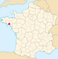
| Vannes | |||||
commune in Morbihan, France       | |||||
| Instance of | |||||
| Location |
| ||||
| Located in or next to body of water | |||||
| Has part(s) | |||||
| Population |
| ||||
| Area |
| ||||
| Elevation above sea level |
| ||||
| official website | |||||
 | |||||
Subcategories
This category has the following 6 subcategories, out of 6 total.
A
- Attraction maps of Vannes (2 F)
O
P
T
- Topographic maps of Vannes (4 F)
U
- Urbanisation maps of Vannes (6 F)
Media in category "Maps of Vannes"
The following 22 files are in this category, out of 22 total.
-
 56 MORBIHAN carte grille communale densite INSEE.png 3,507 × 2,480; 2.25 MB
-
 56260-Vannes-Hydro.jpeg 5,846 × 4,133; 3.82 MB
-
 56260-Vannes-Routes-Hydro.png 3,507 × 2,480; 6.03 MB
-
 56260-Vannes-Sols.png 3,270 × 2,598; 6.29 MB
-
-
 Darioritum (Vannes) Table de Peutinger.png 472 × 180; 72 KB
-
 Diocèse Vannes 1789.svg 2,000 × 1,922; 801 KB
-
 Golfe du Morbihan.png 1,280 × 724; 2.12 MB
-
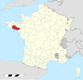
 Map commune FR insee code 56260.png 756 × 605; 93 KB
-
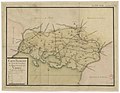
 Map Vannes.jpg 2,178 × 1,806; 1.83 MB
-
-

-
 Plan du centre-ville de vannes.png 851 × 843; 332 KB
-
 Quartier centre ville vannes sans toponyme.svg 445 × 570; 41 KB
-
 Quartier centre ville vannes.svg 445 × 570; 49 KB
-
 Reseau interurbain TPV.png 653 × 531; 137 KB
-
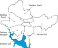 Secteurs de Vannes.png 2,522 × 2,057; 333 KB
-
 Soiaghey Gwened.png 564 × 573; 98 KB
-
 Vannes map.png 396 × 328; 32 KB
-
 Vannes OSM 01.png 849 × 610; 733 KB
-
 Vannes ville.png 915 × 763; 83 KB
-
 Vannes ville.svg 920 × 760; 27 KB


.jpg)


_(14763950122).jpg)
_(14779407941).jpg)


_Table_de_Peutinger.png)