Category:Maps of Washington County, Rhode Island
Wikimedia category | |||||
| Upload media | |||||
| Instance of | |||||
|---|---|---|---|---|---|
| Category combines topics | |||||
| Washington County | |||||
county in Rhode Island, United States   | |||||
| Instance of | |||||
| Named after | |||||
| Location | Rhode Island | ||||
| Capital | |||||
| Inception |
| ||||
| Population |
| ||||
| Area |
| ||||
 | |||||
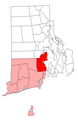
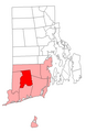
Washington County is located in Rhode Island in the United States.
Subcategories
This category has the following 2 subcategories, out of 2 total.
M
O
Media in category "Maps of Washington County, Rhode Island"
The following 19 files are in this category, out of 19 total.
-
 Charlestown RI highlight.png 397 × 584; 15 KB
-
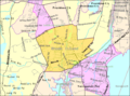 Detailed map of Wakefield-Peacedale, Rhode Island.png 575 × 425; 51 KB
-
 Exeter RI lg.PNG 527 × 811; 24 KB
-
 Hopkinton RI lg.PNG 527 × 811; 24 KB
-
 Map of Rhode Island highlighting Washington County.svg 755 × 1,144; 6 KB
-
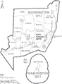 Map of Washington County Rhode Island With Municipal Labels.PNG 769 × 1,044; 89 KB
-
 N Kingstown RI lg.PNG 527 × 811; 24 KB
-
 Rhode Island Municipalities Charlestown Highlighted.png 396 × 584; 33 KB
-
 Rhode Island Municipalities Exeter Highlighted.png 396 × 584; 33 KB
-
 Rhode Island Municipalities Hopkinton Highlighted.png 396 × 584; 33 KB
-
 Rhode Island Municipalities Narragansett Highlighted.png 396 × 584; 33 KB
-
 Rhode Island Municipalities New Shoreham Highlighted.png 396 × 584; 33 KB
-
 Rhode Island Municipalities North Kingstown Highlighted.png 396 × 584; 34 KB
-
 Rhode Island Municipalities Richmond Highlighted.png 396 × 584; 33 KB
-
 Rhode Island Municipalities South Kingstown Highlighted.png 396 × 584; 33 KB
-
 Rhode Island Municipalities Westerly Highlighted.png 396 × 584; 33 KB
-
 Richmond RI lg.PNG 527 × 811; 24 KB
-
 S Kingstown RI lg.PNG 527 × 811; 24 KB
-
 New Shoreham RI lg.PNG 527 × 811; 24 KB


