<nowiki>Category:Maps of Washoe County, Nevada; categoría de Wikimedia; kategori Wikimedia; Wikimedia category; د ويکيمېډيا وېشنيزه; Vikimedya kategorisi; ویکیمیڈیا زمرہ; kategória projektov Wikimedia; категорія проєкту Вікімедіа; 维基媒体分类; Wikimedia-Kategorie; Викимедиина категорија; kategorija na Wikimediji; विकिपीडिया:श्रेणी; page de catégorie de Wikimedia; kategorija na Wikimediji; विकिपीडिया वर्ग; категорија на Викимедији; Wikimedia-Kategorie; Wikimedia-kategori; kategori Wikimédia; تصنيف ويكيميديا; pajenn rummata eus Wikimedia; Wikimedia:ကဏ္ဍခွဲခြင်း; 維基媒體分類; Wikimedia категориясы; categoría de Wikimedia; categoria de Wikimedia; Wikimedia-Kategorie; tudalen categori Wikimedia; kategori e Wikimedias; ردهٔ ویکیپدیا; 维基媒体分类; Wikimedia-kategory; ვიკიპედია:კატეგორიზაცია; ウィキメディアのカテゴリ; categoria Wikimedia; تصنيف بتاع ويكيميديا; විකිමීඩියා ප්රභේද පිටුව; categoria Vicimediorum; Vikipidiya:Shopni; Wikimedia-luokka; Wikimedia category; விக்கிமீடியப் பகுப்பு; катэгорыя ў праекце Вікімэдыя; Викимедиа проектындагы төркем; catigurìa di nu pruggettu Wikimedia; หน้าหมวดหมู่วิกิมีเดีย; Wikimedia:Kategorija; Wikimedia-Kategorie; Wikimedia:Klassys; категория на Уикимедия; categorie a unui proiect Wikimedia; 維基媒體分類; Wikimedia-kategori; kawan Wikimèdia; гурӯҳи Викимедиа; 위키미디어 분류; Wikimedia-bólkur; kategorio en Vikimedio; kategori Wikimedia; categoría de Wikimedia; উইকিমিডিয়া বিষয়শ্রেণী; kategori Wikimedia; 维基媒体分类; וויקימעדיע קאַטעגאָריע; kategorija w projektach Wikimedije; thể loại Wikimedia; Wikimedia projekta kategorija; Wikimedia-kategorie; categoria de um projeto da Wikimedia; 维基媒体分类; категорияд Ангилал; Wikimedia-kategori; kategori Wikimedia; پۆلی ویکیمیدیا; Wikimedia category; Vikimédia ñemohenda; Wikimédia-kategória; વિકિપીડિયા શ્રેણી; Wikimediako kategoria; категория в проекте Викимедиа; Wikimedia-Kategorie; Kategoriya ning Wikimedia; Wikimedia-kategorie; Wîkîmediya:Kategorî; विकिमिडिया श्रेणी; Wikimedia-Kategorie; קטגוריה במיזמי ויקימדיה; Викимедиа проектындагы төркем; κατηγορία εγχειρημάτων Wikimedia; विकिमिडिया श्रेणी; kategoria w projekcie Wikimedia; Wikimedia-kategoriija; гурӯҳи Викимедиа; 維基媒體分類; Wikimedia:Ronnaghys; Wikimedia-Kategorie; categoria di un progetto Wikimedia; Վիքիմեդիայի նախագծի կատեգորիա; Wikimedia category; categurìa 'e nu pruggette Wikimedia; 維基媒體分類; Wikimedia kategooria; Wikimedia-categorie; kategorya ng Wikimedia; 維基媒體分類; ẹ̀ka Wikimedia; kategorie na projektech Wikimedia; categoria de um projeto da Wikimedia; Wikimedia-Kategorie; Wikimedia-categorie; tumbung Wikimedia; kategoria ti Wikimedia; kategorija Wikimedie; Wikimedia proyektındağı törkem; Wikimedia-kategori; Viciméid catagóir; kategori Wikimedia; jamii ya Wikimedia; വിക്കിമീഡിയ വർഗ്ഗം; Wikimedia-categorie; kategori Wikimedia; катэгорыя ў праекце Вікімедыя; زمرو:وڪيپيڊيا زمرا بندي; Викимедиа категорияһы; categoría de Wikimedia; विकिमीडिया श्रेणी; 维基媒体分类; guruhi Vikimedia</nowiki>
Subcategories
This category has the following 2 subcategories, out of 2 total.


 Nevada 28 map.svg 800 × 760; 293 KB
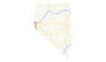 US 395 (NV) map.svg 1,475 × 860; 122 KB
 Anaho Island EO 1819 illustration.jpg 1,730 × 2,450; 365 KB
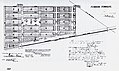 Flanigan townsite map.jpg 4,855 × 2,883; 2.86 MB
 Nevada Senate District 13 (2012).png 2,503 × 3,600; 353 KB
 Nevada Senate District 14 (2012).png 2,503 × 3,600; 360 KB
 Nevada Senate District 15 (2012).png 2,503 × 3,600; 354 KB
 Nevada Senate District 16 (2012).png 2,503 × 3,600; 354 KB
 Reno Nevada US street map.svg 3,730 × 3,830; 9.03 MB
 Reno-Sparks-Fernley CSA.png 321 × 465; 12 KB


 Washoe County Nevada Incorporated and Unincorporated areas Reno Highlighted.svg 1,340 × 2,053; 82 KB
 Washoe County Nevada Incorporated and Unincorporated areas Sparks Highlighted.svg 1,547 × 2,472; 57 KB


_map.svg)


.png)
.png)
.png)
.png)


