Category:Maps of borders of Libya
Countries of Africa: Algeria · Angola · Botswana · Burkina Faso · Burundi · Cameroon · Central African Republic · Chad · Democratic Republic of the Congo · Republic of the Congo · Djibouti · Egypt‡ · Eswatini · Ethiopia · Gabon · Ghana · Guinea · Guinea-Bissau · Ivory Coast · Kenya · Lesotho · Liberia · Libya · Malawi · Mali · Mauritania · Morocco · Mozambique · Namibia · Niger · Nigeria · Rwanda · Senegal · Sierra Leone · Somalia · South Africa · South Sudan · Sudan · Tanzania · Togo · Tunisia · Uganda · Zambia · Zimbabwe
Limited recognition: Ambazonia · Somaliland – Other areas: Western Sahara
‡: partly located in Africa
Limited recognition: Ambazonia · Somaliland – Other areas: Western Sahara
‡: partly located in Africa
Media in category "Maps of borders of Libya"
The following 13 files are in this category, out of 13 total.
-
 20th parallel Africa-as.svg 400 × 400; 55 KB
-
 20th parallel Africa-bn.svg 400 × 400; 55 KB
-
 20th parallel Africa.svg 400 × 400; 55 KB
-
 Algeria-Libya boundary.jpg 3,155 × 4,201; 9.43 MB
-
 Chad-Libya border.jpg 2,814 × 2,058; 531 KB
-
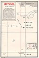 Egypt-Libya border map.jpg 671 × 986; 158 KB
-
 Fort Charlet (Djanet).jpg 7,977 × 8,082; 7.03 MB
-
 Fort Tarat.jpg 9,147 × 7,299; 8.18 MB
-
 Libya-Niger Boundary.jpg 1,924 × 1,248; 296 KB
-
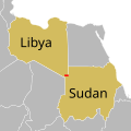
 Libya-Sudan border map.jpg 983 × 721; 157 KB
-
 Libya-Tunisia border.png 793 × 1,117; 250 KB
-
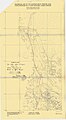 Provisional Map of the Algerian-Libyan Frontier Zone 26.30-27.30.jpg 1,449 × 2,631; 584 KB
-
 Provisional Map of the Algerian-Libyan Frontier Zone 27.30-29.00.jpg 1,495 × 3,698; 879 KB


.jpg)


