Category:Maps of the Massachusetts Bay Transportation Authority rapid transit system
Subcategories
This category has the following 2 subcategories, out of 2 total.
M
- Maps of the MBTA Silver Line (10 F)
Media in category "Maps of the Massachusetts Bay Transportation Authority rapid transit system"
The following 32 files are in this category, out of 32 total.
-
 1967 MBTA subway map at Orient Heights.jpg 1,660 × 1,536; 546 KB
-
 1967 MBTA subway map.jpg 1,536 × 1,634; 787 KB
-
 Central Mass Branch final passenger schedule.jpg 1,042 × 674; 122 KB
-
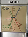 MBTA 3400 at Seashore Trolley Museum 332 (36889639803).jpg 3,024 × 4,032; 1.53 MB
-
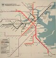
 1971 MBTA rapid transit map.jpg 2,707 × 2,832; 5.03 MB
-
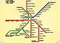 1973 MBTA rapid transit map card.jpg 2,081 × 1,507; 276 KB
-
 1974 black background MBTA subway map.png 3,177 × 3,500; 22.87 MB
-
 Haymarket North Extension flier April 4 1975.jpg 1,091 × 1,701; 1.5 MB
-
 1978 MBTA subway map.png 855 × 822; 1.28 MB
-
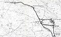
 1978 map of the Red Line Northwest Extension.jpg 2,534 × 884; 353 KB
-
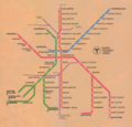
 1979 MBTA subway map.png 975 × 967; 1.45 MB
-
 1988 MBTA subway map.png 552 × 524; 450 KB
-
 1998 MBTA subway map.tiff 1,198 × 1,236; 4.24 MB
-
 2013 unofficial MBTA subway map by Michael Kvrivishvili.png 3,300 × 3,300; 1.35 MB
-
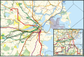
 Alternative alignments for the Red Line Northwest Extension.jpg 5,018 × 3,095; 3.22 MB
-
 Ashmont Mattapan High Speed Line map.svg 961 × 724; 4.78 MB
-
 Former passageway on inbound platform at Hynes Convention Center, December 2015.JPG 4,320 × 3,240; 2.53 MB
-
 Harvard stations simplified map.svg 921 × 1,063; 47 KB
-
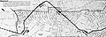
 Main Line Elevated map, 1905 (14760990565).jpg 3,664 × 1,468; 391 KB
-

-
 MBTA Blue Line.svg 1,739 × 243; 55 KB
-
 MBTA Boston subway map.png 3,062 × 2,415; 650 KB
-
 MBTA Orange Line.svg 2,889 × 386; 160 KB
-
 MBTA Rapid Transit (1971).svg 1,250 × 1,600; 20 KB
-
 MBTA Rapid Transit (alternative).svg 1,500 × 2,250; 25 KB
-
 MBTA Rapid Transit.svg 1,200 × 1,700; 25 KB
-
 MBTA Red Line.svg 3,653 × 539; 163 KB
-
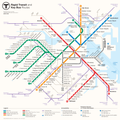
 MBTA Subway Geographic Map (2022).svg 1,600 × 1,069; 953 KB
-
 MBTA subway map from WikiTravel, 2006.png 744 × 1,059; 174 KB
-
 MBTA Track map.png 960 × 960; 183 KB
-
 MBTA Urban Ring map.svg 800 × 800; 304 KB
-
 Signage at Woodland MBTA station.jpg 2,576 × 1,932; 1.12 MB


.jpg)


.svg)


.jpg)
.svg)
.svg)