Category:Maps of the Weimar Republic
Use the appropriate category for maps showing all or a large part of Germany. See subcategories for smaller areas:
| If the map shows | Category to use |
|---|---|
| Germany on a recently created map | Category:Maps of Germany or its subcategories |
| Germany on a map created more than 70 years ago | Category:Old maps of Germany or its subcategories |
| the history of Germany on a recently created map | Category:Maps of the history of Germany or its subcategories |
| the history of Germany on a map created more than 70 years ago | Category:Old maps of the history of Germany or its subcategories |
Wikimedia category | |||||
| Upload media | |||||
| Instance of | |||||
|---|---|---|---|---|---|
| Category combines topics | |||||
| Weimar Republic | |||||
Germany in the years 1918/1919–1933 .svg) .svg)   | |||||
| Spoken text audio | |||||
| Pronunciation audio | |||||
| Instance of | |||||
| Facet of | |||||
| Named after | |||||
| Location |
| ||||
| Capital | |||||
| Basic form of government |
| ||||
| Legislative body | |||||
| Official language | |||||
| Anthem |
| ||||
| Currency |
| ||||
| Head of state |
| ||||
| Head of government |
| ||||
| Inception |
| ||||
| Dissolved, abolished or demolished date |
| ||||
| Population |
| ||||
| Area |
| ||||
| Religion or worldview | |||||
| Replaces |
| ||||
| Replaced by |
| ||||
| Different from | |||||
 | |||||
Subcategories
This category has the following 8 subcategories, out of 8 total.
Media in category "Maps of the Weimar Republic"
The following 32 files are in this category, out of 32 total.
-
 Flag map of Germany (1919).svg 1,048 × 846; 39 KB
-
 AltReich2.png 2,188 × 2,276; 448 KB
-
 Besetzte Gebiete Deutschlands 1925 komplett.jpg 7,962 × 12,590; 12.97 MB
-
 Besetzte Gebiete nach dem Stande vom 1. Juli 1923.jpg 4,128 × 8,645; 35.5 MB
-
 Brückenkopf Mainz - Besatzungsgebiet im Volksstaat Hessen.jpg 911 × 1,225; 801 KB
-
 Brückenkopf Mainz - norwestlicher Abschnitt.jpg 737 × 638; 90 KB
-
 Brückenkopf Mainz – Besatzungsgebiet nach der Ruhrbesetzung 1923 2.jpg 721 × 519; 115 KB
-
 Brückenkopf Mainz – Gesamtansicht.jpg 1,022 × 937; 793 KB
-

-
 Brückenkopf Mainz – Grenzverlauf zwischen Frankfurt-Griesheim und Oberreifenberg.jpg 2,537 × 2,386; 1.22 MB
-
 Danzig 1939.png 695 × 597; 77 KB
-
 Flag Map of the Weimar Republic.jpg 1,000 × 1,080; 89 KB
-
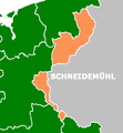
 Grenzmark PW (cropped).png 1,284 × 1,453; 247 KB
-
 Grenzmark PW.png 1,299 × 1,772; 271 KB
-
 Map of the German State Churches in the Weimar Republic (1922).jpg 976 × 818; 79 KB
-
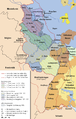
 Map of the Weimar Republic c. 1919.png 1,878 × 1,288; 274 KB
-
 Memelland 1923-1939.png 733 × 560; 16 KB
-
 Occupation in Germany by district, 1925.svg 1,512 × 1,179; 4.58 MB
-
 Occupation of the Rhineland.png 1,505 × 2,362; 533 KB
-
 OF Besatzungsgrenze im Kreis Offenbach.jpg 982 × 706; 254 KB
-
 Plebiscyt na Górnym Śląsku-mapa.gif 815 × 807; 31 KB
-
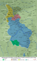
 Population density in Germany by district, 1925.svg 1,512 × 1,179; 4.32 MB
-
 RBGmPWP1922.png 311 × 336; 7 KB
-
 Religion in Germany by district, 1925.svg 1,512 × 1,179; 4.51 MB
-
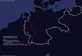
 Western Germany 1923 en.png 1,406 × 2,276; 2.95 MB
-
 SPK-Karte Rheinlandbesetzung 2023.jpg 799 × 1,786; 877 KB
-
 SPK-Karte Rheinlandbesetzung mit Brückenköpfen.jpg 404 × 812; 89 KB
-
 Territorial changes of Poland 1918.jpg 850 × 700; 305 KB
-
 Territorial changes of Poland 1918b.jpg 850 × 700; 318 KB
-
 Western Germany 1923 ar.png 1,406 × 2,276; 3.72 MB
-
 احتلال راينلاند.jpg 1,505 × 2,362; 836 KB
-
 امپراتوری آلمان - جمهوری وایمار - رایش سوم ۱۹۱۹-۱۹۳۷.png 1,024 × 930; 660 KB
.svg)


.png)

.jpg)


