Category:Maps of the exploration of Australia
Maps old and new indicating the exploration of Australia.
See also
editMedia in category "Maps of the exploration of Australia"
The following 56 files are in this category, out of 56 total.
-
 HODGSON(1846) EXPLORATION ROUTE FROM JIMBOUR TO NORTH WEST.jpg 2,237 × 2,703; 2.18 MB
-
 AC Gregory Map of Exploration.png 2,050 × 1,339; 393 KB
-
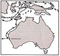
 Australia discoveries by Europeans before 1813 de.png 1,200 × 1,105; 1.47 MB
-
 Australia discoveries by Europeans before 1813 en.png 1,200 × 1,105; 1.47 MB
-
 Australia discoveries by Europeans before 1813 hy.png 651 × 599; 652 KB
-

-

-
 Bass journeys.png 1,527 × 1,616; 258 KB
-
 Bass-map.jpg 625 × 293; 26 KB
-
 Blaxland-map.jpg 625 × 280; 28 KB
-
 Burke and wills australia map.jpg 689 × 1,237; 45 KB
-
 Burke and Wills Track.png 689 × 1,237; 232 KB
-
 Burkeandwills-map.jpg 627 × 288; 34 KB
-
 Cook-map.jpg 630 × 288; 24 KB
-
 Dampier-map.jpg 300 × 277; 56 KB
-
 Ernest Giles expeditions.png 1,551 × 1,074; 293 KB
-
 Expeditions of John Forrest.jpg 1,000 × 775; 201 KB
-
 Eyre-map.jpg 637 × 293; 22 KB
-
 Flinders Map v1P.png 754 × 438; 78 KB
-
 Flinders v10.svg 754 × 438; 118 KB
-
 Flinders-map from project gutenberg.jpg 637 × 296; 30 KB
-
 Forrest-map.jpg 624 × 273; 21 KB
-
 Frank Hann travels.png 922 × 913; 1.22 MB
-

-
 Gregory-map.jpg 627 × 296; 25 KB
-
 Hume&hovellmap1.gif 1,024 × 768; 644 KB
-
 Hume&hovellMap4.jpg 912 × 587; 192 KB
-
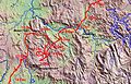
 Image-Arnhem Land topographic sketch.jpg 2,438 × 1,694; 363 KB
-
 Interior of NSW 1822 Oxley.jpg 1,400 × 933; 1.07 MB
-
 Itinerario del primo viaggio di James Cook.svg 2,754 × 1,397; 1.59 MB
-
 Karte Cook Seereise nr1.png 1,263 × 632; 97 KB
-
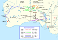
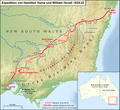 Karte Expedition Hume und Hovell 1824.png 1,200 × 1,103; 1.31 MB
-
 Karte Expedition Willem Jansz 1605-1606.png 1,200 × 740; 928 KB
-
 Karte Expedition William Dampier 1699.png 1,200 × 833; 1.11 MB
-
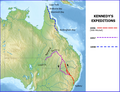 Kennedy map v2.png 782 × 600; 512 KB
-
 Kennedy-map.jpg 625 × 288; 23 KB
-
 King-map.jpg 652 × 315; 43 KB
-
 Leichhardt Reise 3 Karte deutsch.svg 2,055 × 1,847; 445 KB
-
 Leichhardt Reise 3 Karte deutsch2.svg 2,055 × 1,847; 500 KB
-
 Leichhardt-map.jpg 636 × 296; 23 KB
-
 Maps of Australia showing progess of exploration(GN04062).jpg 3,264 × 2,448; 1.03 MB
-
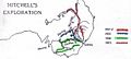
 Mitchell (Thomas) exploration map.svg 776 × 1,065; 515 KB
-
 Mitchell explorations NSW.png 776 × 1,065; 211 KB
-
 Mitchell-map.jpg 622 × 282; 25 KB
-

-
 Oxley-map.jpg 634 × 293; 31 KB
-
 Routes of Eyre (1840 and 1841) retouched.jpg 800 × 509; 204 KB
-
 Routes of Eyre (1840 and 1841).jpg 800 × 509; 81 KB
-
 Stuart-map.jpg 595 × 296; 19 KB
-
 Sturt and Hume and Hovell expeditions.jpg 800 × 519; 79 KB
-
 Sturt-map.jpg 634 × 290; 31 KB
-
 Swan River Exploration.png 775 × 1,747; 396 KB
-
 Tasmanroutes.PNG 600 × 455; 57 KB
-
 Tietkens exploration.png 897 × 598; 716 KB
-
 Tietkens Exploration.svg 895 × 597; 100 KB
-
 Torres-map.jpg 500 × 306; 91 KB
_EXPLORATION_ROUTE_FROM_JIMBOUR_TO_NORTH_WEST.jpg)


_auch_Polynesien_oder_Inselwelt,_insgemein_der_f%C3%BCnfte_Welttheil_genannt_-_UvA-BC_OTM_HB-KZL_69_11_05.jpg)
_auch_Polynesien_oder_Inselwelt,_insgemein_der_f%C3%BCnfte_Welttheil_genannt_-_UvA-BC_OTM_HB-KZL_101.20.02.jpg)


.jpg)
_exploration_map.svg)


_retouched.jpg)
.jpg)


