Category:Maps showing 1776
| ← 1770 1771 1772 1774 1775 1776 1777 1778 1779→ |
English: Maps showing the year 1776 (i.e. history maps)
See also category: 1776 maps. and 1770s maps for more maps showing this year usually created not long after the given year.
See also category: 1776 maps. and 1770s maps for more maps showing this year usually created not long after the given year.
Subcategories
This category has only the following subcategory.
M
Media in category "Maps showing 1776"
The following 7 files are in this category, out of 7 total.
-
-

-
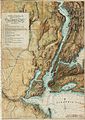
 Map of British Military Operations in New York and New Jersey in 1776 (6 MB).jpg 1,846 × 2,559; 5.27 MB
-
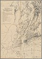 Map of British Military Operations in New York and New Jersey in 1776 (73 MB).jpg 7,510 × 10,412; 69.28 MB
-
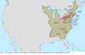 United States Central change 1776-07-04.png 2,046 × 1,321; 273 KB
-
 United States Central change 1776-09-20.png 2,046 × 1,321; 242 KB
-
 United States Central change 1776-12-20.png 2,046 × 1,321; 239 KB

)%27_(11231430313).jpg)
.jpg)
.jpg)


