Category:Maps showing 1810
| ← 1810 1811 1812 1813 1814 1815 1816 1817 1818 1819→ |
English: Maps showing the year 1810 (i.e. history maps)
See also category: 1810 maps. and 1810s maps for old maps created in this time.
See also category: 1810 maps. and 1810s maps for old maps created in this time.
Media in category "Maps showing 1810"
The following 5 files are in this category, out of 5 total.
-
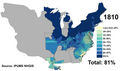
 Black American 1810 County.png 14,950 × 8,865; 4.6 MB
-
 United States 1809-1810-04.png 1,000 × 677; 115 KB
-
 United States 1810-04-1810-10.png 1,000 × 677; 116 KB
-
 United States 1810-10-1812-04.png 1,000 × 677; 108 KB
-
 White Americans 1810 County.png 14,950 × 8,865; 7.33 MB


