Category:Marienkirche (Prenzlau)
| Object location | | View all coordinates using: OpenStreetMap |
|---|
church building in Uckermark district, Germany    | |||||
| Upload media | |||||
| Instance of | |||||
|---|---|---|---|---|---|
| Named after | |||||
| Made from material | |||||
| Location | Prenzlau, Uckermark District, Brandenburg, Germany | ||||
| Architectural style | |||||
| Heritage designation | |||||
 | |||||
This is the category of the Brandenburger Baudenkmal (cultural heritage monument) with the ID 09130108 (Wikidata)
|
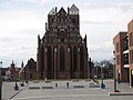
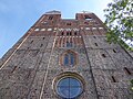
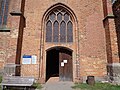
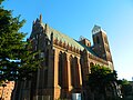
Deutsch: Die Sankt Marienkirche in Prenzlau, Mark Brandenburg, gehört und dient einer Gemeinde der unierten Evangelischen Kirche Berlin-Brandenburg-Schlesische Oberlausitz. Die Kirche entstand 1325–1339. 1945 ausgebrannt, stürzten die Gewölbe in der Folge ein. Wiederherstellung des Äußeren 1970–1995, Gewölbe bis 2020 im Wiederaufbau.
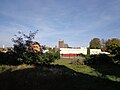
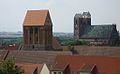
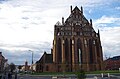
English: The St. Mary's Church in Prenzlau, March of Brandenburg, Germany, is owned and used by a congregation within the Evangelical Church of Berlin-Brandenburg-Silesian Upper Lusatia, a united Protestant church body of Calvinist, Lutheran and united congregations. The church was erected between 1325 and 1339 using parts of its predecessor begun 1235. In 1945 the church completely burnt out, its vaults collapsed following the fire. The exterior was restored between 1970 and 1995, the interior with the vaults currently being reconstructed.
Subcategories
This category has the following 3 subcategories, out of 3 total.
I
V
Media in category "Marienkirche (Prenzlau)"
The following 53 files are in this category, out of 53 total.
-
 20150221 xl Prenzlau Marienkirche 2911.JPG 4,000 × 3,000; 2.82 MB
-
 20150221 xl Prenzlau Marienkirche 2922.JPG 4,000 × 3,000; 2.19 MB
-
 20150221 xl Windkraftanlagen bei Prenzlau - Geschichte trifft Zukunft 2865.JPG 3,000 × 4,000; 2.66 MB
-
 2023-09-09 Prenzlau 01.jpg 4,608 × 3,456; 6.25 MB
-
 2023-09-09 Prenzlau 02.jpg 4,608 × 3,456; 6.4 MB
-
 2023-09-09 Prenzlau 03.jpg 4,608 × 3,456; 6.41 MB
-
 2023-09-09 Prenzlau 13.jpg 3,456 × 4,608; 6.45 MB
-
 2023-09-09 Prenzlau 14.jpg 4,608 × 3,456; 6.42 MB
-
 2023-09-09 Prenzlau 15.jpg 4,608 × 3,456; 6.3 MB
-
 2023-09-09 Prenzlau 16.jpg 4,608 × 3,456; 6.22 MB
-
 2023-09-09 Prenzlau 35.jpg 4,608 × 3,456; 6.28 MB
-
 2023-09-09 Prenzlau 45.jpg 4,608 × 3,456; 6.34 MB
-
 2023-09-09 Prenzlau 46.jpg 4,608 × 3,456; 6.37 MB
-
 2023-09-09 Prenzlau 47.jpg 4,608 × 3,456; 6.32 MB
-
 765 PZ Marien Nordseite v NW.JPG 4,000 × 3,000; 1.39 MB
-
 766 PZ Marien Nordvorhalle.JPG 3,000 × 4,000; 1.5 MB
-
 767 PZ Marien Nordseite W.JPG 3,000 × 4,000; 1.44 MB
-
 Fotothek df ps 0004752 Kirchen.jpg 800 × 805; 252 KB
-
 Fotothek df ps 0004753 Kirchen.jpg 800 × 817; 254 KB
-
 Geburtsstadt - mein foto.jpg 1,024 × 629; 447 KB
-
 PrenzlauSt-Marien002.jpg 5,429 × 4,000; 22.93 MB
-
 Kościół mariacki w Prenzlau - panoramio (1).jpg 560 × 747; 238 KB
-
 Kościół mariacki w Prenzlau - panoramio.jpg 747 × 560; 223 KB
-
 Marienkirche in Prenzlau.jpg 810 × 1,080; 286 KB
-
 Marienkirche Prenzlau 2013.jpg 3,008 × 2,000; 3.63 MB
-
 Marienkirche Prenzlau 2014-04-19.JPG 2,804 × 2,256; 2.11 MB
-
 Marienkirche Prenzlau.jpg 4,928 × 3,264; 1.19 MB
-
 Marienkirche Prenzlau.JPG 2,048 × 1,536; 1.89 MB
-
 Marienkirche Prenzlau1.JPG 1,200 × 1,600; 396 KB
-
 Marienkirche Prenzlau2.JPG 1,391 × 1,046; 499 KB
-
 Marienkirche Prenzlau3.JPG 1,200 × 1,600; 343 KB
-
 MarienkirchePrenzlau002.jpg 5,595 × 3,066; 17.14 MB
-
 Parish church of St Mary Prenzlau 02.jpg 2,736 × 3,648; 1.82 MB
-
 Parish church of St Mary Prenzlau 03.jpg 3,648 × 2,736; 1.67 MB
-
 Parish church of St Mary Prenzlau 04.jpg 2,736 × 3,648; 1.84 MB
-
 Parish church of St Mary Prenzlau 05.jpg 2,736 × 3,648; 1.99 MB
-
 Parish church of St Mary Prenzlau 06.jpg 2,736 × 3,648; 1.63 MB
-

-
 Prenzlau - Marienkirche - geo.hlipp.de - 4086.jpg 480 × 640; 92 KB
-

-

-
 Prenzlau 10-2016 photo06.jpg 3,615 × 2,892; 6.17 MB
-
 Prenzlau Marienkirche.jpg 850 × 1,140; 114 KB
-
 Prenzlau Martin Luther.jpg 1,890 × 2,640; 781 KB
-
 Prenzlau St Marien.jpg 2,460 × 2,250; 867 KB
-
 Prenzlau, Kościół Mariacki - panoramio.jpg 972 × 729; 314 KB
-
 Stadtansicht Prenzlau.JPG 1,600 × 1,200; 401 KB
-
 PrenzlauChurch2.jpg 4,320 × 3,240; 2.96 MB
-
 PrenzlauSt-Marien001.jpg 4,327 × 4,000; 19.6 MB
-
 Ruina kościoła, z tyłu kościól mariacki - Prenzlau - panoramio.jpg 747 × 560; 202 KB
-
 St. Marien Prenzlau 1992.jpg 1,982 × 1,426; 1.86 MB
-
 Uckermark 044 Kopie.jpg 1,600 × 2,400; 1.73 MB
-
 20150221 xl Windkraftanlagen bei Prenzlau - Geschichte trifft Zukunft 2859.JPG 4,000 × 3,000; 2.26 MB


.jpg)


_-_geo.hlipp.de_-_37473.jpg)

_-_geo.hlipp.de_-_37467.jpg)
_-_geo.hlipp.de_-_37464.jpg)


