Category:Martinsthorpe
English: Martinsthorpe is a civil parish in the county of Rutland in the East Midlands of England and a deserted village. (→Martinsthorpe)
Nederlands: Martinsthorpe is een plaats en civil parish in het bestuurlijke gebied Rutland, in het Engelse graafschap Rutland. (→Martinsthorpe)
Polski: Martinsthorpe – wieś w Anglii, w hrabstwie Rutland. Leży 5 km na południe od miasta Oakham i 132 km na północ od Londynu. W 2001 miejscowość liczyła 0 mieszkańców. (→Martinsthorpe)
village in Rutland, UK  | |||||
| Upload media | |||||
| Instance of | |||||
|---|---|---|---|---|---|
| Location | Rutland, East Midlands, England | ||||
| Area |
| ||||
 | |||||
Media in category "Martinsthorpe"
The following 28 files are in this category, out of 28 total.
-
 Cattle grid on the edge of Martinsthorpe - geograph.org.uk - 3897725.jpg 1,600 × 1,015; 463 KB
-
 Earthworks at Martinsthorpe - geograph.org.uk - 3897796.jpg 1,600 × 1,102; 577 KB
-
 Earthworks at Martinsthorpe - geograph.org.uk - 3897813.jpg 1,600 × 1,148; 401 KB
-
 Ewes and lambs with the backdrop of Rutland Water - geograph.org.uk - 3897199.jpg 1,600 × 1,055; 434 KB
-
 Footpath heading towards Brooke - geograph.org.uk - 5719743.jpg 3,776 × 2,520; 3.53 MB
-
 Gunthorpe Hall - geograph.org.uk - 3897765.jpg 1,600 × 1,386; 562 KB
-
 Hedge and fields next to the Macmillan Way Footpath - geograph.org.uk - 3897120.jpg 1,600 × 1,178; 621 KB
-
 Information board at Martinsthorpe - geograph.org.uk - 3897732.jpg 1,600 × 1,200; 560 KB
-
 Macmillan Way footpath at Martinsthorpe - geograph.org.uk - 3897178.jpg 1,600 × 1,095; 587 KB
-
 Macmillan Way footpath to Manton - geograph.org.uk - 3897041.jpg 1,600 × 1,125; 662 KB
-
 House at Martinsthorpe - geograph.org.uk - 317873.jpg 640 × 480; 88 KB
-
 Rear of the house at Martinsthorpe - geograph.org.uk - 317876.jpg 640 × 480; 138 KB
-
 Modern track leading to Gunthorpe - geograph.org.uk - 3897750.jpg 1,600 × 1,021; 410 KB
-
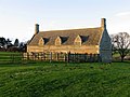
 Old Hall Farmhouse - geograph.org.uk - 3897808.jpg 1,600 × 1,168; 548 KB
-
 Old Hall Farmhouse at Martinsthorpe - geograph.org.uk - 3897816.jpg 1,600 × 1,125; 462 KB
-
 Old Hall Farmhouse at Martinsthorpe - geograph.org.uk - 3897950.jpg 1,600 × 1,193; 542 KB
-
 Old Hall farmhouse, Martinsthorpe - geograph.org.uk - 5719763.jpg 3,776 × 2,520; 3.89 MB
-
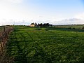
 Site of the deserted medieval village of Martinsthorpe - geograph.org.uk - 3897190.jpg 1,600 × 1,112; 510 KB
-
 Stone wall at Martinsthorpe - geograph.org.uk - 3897832.jpg 1,600 × 1,217; 653 KB
-
 Towards Martinthorpe - geograph.org.uk - 1008287.jpg 640 × 480; 78 KB
-
 Track and Macmillan Way Footpath - geograph.org.uk - 3897077.jpg 1,600 × 1,339; 582 KB
-
 Track heading towards Martinsthorpe - geograph.org.uk - 3897141.jpg 1,600 × 1,200; 681 KB
-
 Track to Gunthorpe Hall - geograph.org.uk - 5719736.jpg 3,776 × 2,520; 3.44 MB
-
 Tractor and farmland near America Lodge - geograph.org.uk - 3897052.jpg 1,600 × 896; 373 KB
-
 View north across the Gwash Valley - geograph.org.uk - 3897126.jpg 1,600 × 1,338; 478 KB
-
 View towards Rutland Water - geograph.org.uk - 3897839.jpg 1,600 × 1,173; 478 KB
-
 View towards the village of Preston - geograph.org.uk - 3897148.jpg 1,600 × 1,111; 389 KB
-
 Site of Martinsthorpe Village - geograph.org.uk - 317791.jpg 640 × 480; 77 KB


