Category:Melchet Park and Plaitford
English: Melchet Park and Plaitford is a civil parish in the Test Valley district of Hampshire, England.
civil parish in Test Valley, Hampshire, England | |||||
| Upload media | |||||
| Instance of | |||||
|---|---|---|---|---|---|
| Location | Test Valley, Hampshire, South East England, England | ||||
 | |||||
Subcategories
This category has the following 2 subcategories, out of 2 total.
P
S
Media in category "Melchet Park and Plaitford"
The following 45 files are in this category, out of 45 total.
-
 Autumn dusk at Sturtmoor Pond - geograph.org.uk - 5615494.jpg 640 × 360; 62 KB
-
 Belted Galloway, Manor Farm - geograph.org.uk - 2434704.jpg 640 × 480; 72 KB
-
 Belted Galloways, Manor Farm - geograph.org.uk - 2434695.jpg 640 × 481; 72 KB
-
 Canada Common, burnt gorse - geograph.org.uk - 4698145.jpg 1,024 × 768; 209 KB
-
 Dovecote and doves at Manor Farm - geograph.org.uk - 5757119.jpg 640 × 427; 80 KB
-
 Ford and footbridge in Giles Lane - geograph.org.uk - 5757124.jpg 640 × 427; 130 KB
-
 Ford at Plaitford - geograph.org.uk - 4807063.jpg 1,086 × 724; 371 KB
-
 Ford at Plaitford - geograph.org.uk - 4807082.jpg 1,086 × 724; 479 KB
-
 Gate and lake at Manor Farm - geograph.org.uk - 5757120.jpg 640 × 427; 82 KB
-
 Giles Lane fords River Blackwater - geograph.org.uk - 3429650.jpg 3,647 × 2,527; 2.52 MB
-
 Haystack on Melchet Court Estate - geograph.org.uk - 5923650.jpg 1,024 × 683; 266 KB
-
 Junction of Pound Hill with Pound Lane - geograph.org.uk - 3429700.jpg 3,648 × 2,736; 3.1 MB
-

-
 Lengthening shadows on Plaitford Common - geograph.org.uk - 5922448.jpg 1,024 × 683; 235 KB
-
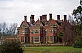 Melchet Park, Sherfield English - geograph.org.uk - 3380996.jpg 640 × 415; 166 KB
-

-
 Plaitford Common - geograph.org.uk - 4263449.jpg 1,024 × 768; 121 KB
-
 Plaitford Common - geograph.org.uk - 4263937.jpg 1,024 × 768; 171 KB
-
 Plaitford Common - geograph.org.uk - 4263961.jpg 1,024 × 768; 191 KB
-
 Plaitford Common - geograph.org.uk - 4698158.jpg 1,024 × 768; 199 KB
-
 Plaitford Common, boundary ditch - geograph.org.uk - 4263958.jpg 714 × 1,024; 278 KB
-
 Plaitford Common, ditch - geograph.org.uk - 4263947.jpg 1,024 × 768; 250 KB
-
 Plaitford Common, embankments - geograph.org.uk - 4278134.jpg 1,024 × 768; 158 KB
-
 Plaitford Common, footbridge - geograph.org.uk - 4263953.jpg 1,024 × 768; 146 KB
-
 Plaitford Common, forestry track - geograph.org.uk - 4263932.jpg 768 × 1,024; 192 KB
-

-
 Plaitford Common, ponies - geograph.org.uk - 4263918.jpg 1,024 × 768; 225 KB
-
 Plaitford Common, ponies - geograph.org.uk - 4263944.jpg 1,024 × 768; 132 KB
-
 Plaitford Common, power lines - geograph.org.uk - 4263939.jpg 768 × 1,024; 135 KB
-
 Plaitford Common, tussocks - geograph.org.uk - 4263927.jpg 1,024 × 768; 201 KB
-
 Plaitford Common, wetland - geograph.org.uk - 4263933.jpg 1,024 × 768; 149 KB
-
 Plaitford Manor Farmhouse and buildings - geograph.org.uk - 3429684.jpg 3,423 × 2,574; 2 MB
-
 Plaitford, horse grazing - geograph.org.uk - 4263922.jpg 1,024 × 768; 207 KB
-
 Plaitford, Shoe Inn - geograph.org.uk - 4263903.jpg 1,024 × 768; 125 KB
-

-
 Sheep grazing at Melchet Park - geograph.org.uk - 5923622.jpg 1,024 × 683; 300 KB
-
 Sherfield English Lane junction with Flowers Lane - geograph.org.uk - 3226224.jpg 3,648 × 2,510; 1.97 MB
-
 St. Peter's Church, Plaitford - geograph.org.uk - 5757116.jpg 640 × 427; 89 KB
-

-
 Sweetbriar Cottage - geograph.org.uk - 3226496.jpg 3,445 × 2,539; 1.78 MB
-
 Trees reflected in Melchet Pond - geograph.org.uk - 5923619.jpg 1,024 × 683; 283 KB
-
 View across fields at Melchet Park - geograph.org.uk - 5923621.jpg 1,024 × 683; 238 KB
-
 View from the front of Melchet Court - geograph.org.uk - 5923626.jpg 1,024 × 683; 221 KB
-
 West Wellow Common, ditch - geograph.org.uk - 4698182.jpg 1,024 × 768; 242 KB
-
 Woodland track at Woodfalls - geograph.org.uk - 5923629.jpg 1,024 × 683; 318 KB


