Category:Borough of Test Valley
borough in Hampshire, United Kingdom  | |||||
| Upload media | |||||
| Instance of |
| ||||
|---|---|---|---|---|---|
| Location | Hampshire, South East England, England | ||||
| Capital | |||||
| Legislative body |
| ||||
| Population |
| ||||
| Area |
| ||||
| official website | |||||
 | |||||
Subcategories
This category has the following 63 subcategories, out of 63 total.
Media in category "Borough of Test Valley"
The following 87 files are in this category, out of 87 total.
-

-

-
-
-

-

-

-

-

-

-
 A27 approaching Shootash - geograph.org.uk - 3922999.jpg 640 × 427; 123 KB
-
 A27 at Embley Lane junction - geograph.org.uk - 3923423.jpg 640 × 451; 111 KB
-
 A27 bridge over the M27 - geograph.org.uk - 2857281.jpg 640 × 430; 40 KB
-
 Ashley's Copse - panoramio (1).jpg 3,872 × 2,592; 4.51 MB
-
 Ashley's Copse - panoramio.jpg 3,872 × 2,592; 4.43 MB
-
 Bakers Drive open space - geograph.org.uk - 1713665.jpg 2,272 × 1,704; 1.69 MB
-
 Bevisbury Camp - panoramio (1).jpg 3,872 × 2,592; 4.88 MB
-
 Bevisbury Camp - panoramio.jpg 3,872 × 2,592; 4.88 MB
-
 Blackhill, cattle grid - geograph.org.uk - 4717469.jpg 1,024 × 768; 227 KB
-
 Blackhill, gate - geograph.org.uk - 4717445.jpg 1,024 × 768; 282 KB
-
 Blackhill, National Park marker - geograph.org.uk - 4717479.jpg 1,024 × 768; 226 KB
-
 BrookFarmHouse.gif 240 × 159; 23 KB
-
 Canada Common Car Park - geograph.org.uk - 4698118.jpg 1,024 × 768; 132 KB
-
 Canada Common, track - geograph.org.uk - 4698135.jpg 1,024 × 768; 173 KB
-
 Canada Common, uneven ground - geograph.org.uk - 4698127.jpg 1,024 × 768; 238 KB
-
 Canada, Holly Bank Farm - geograph.org.uk - 4698165.jpg 1,024 × 768; 201 KB
-
 Canada, Rockingham Arms - geograph.org.uk - 4694995.jpg 1,024 × 680; 171 KB
-
 Caravan and Camp site - geograph.org.uk - 406320.jpg 640 × 480; 145 KB
-
 Chilworth Drove crosses M27 motorway - geograph.org.uk - 1199485.jpg 640 × 426; 165 KB
-
 Crossroads at Sherfield English - geograph.org.uk - 3922965.jpg 640 × 377; 56 KB
-

-
 Danebury Hill Fort entrance - panoramio.jpg 3,072 × 2,304; 2.88 MB
-
 Danebury Hill Fort outer ring - panoramio.jpg 3,072 × 2,304; 3.22 MB
-

-
-
 Eastleigh Works Centenary Open Days 30.jpg 4,000 × 3,000; 1.2 MB
-
 Entrance to Forest Edge Park - geograph.org.uk - 3923383.jpg 640 × 415; 92 KB
-
-
 Fallen tree blocking A36 - geograph.org.uk - 3794373.jpg 640 × 482; 106 KB
-

-
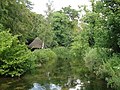 Fishing Hut - panoramio.jpg 2,895 × 2,171; 3.21 MB
-

-
-
 Gardeners Lane approaching A27 - geograph.org.uk - 3923390.jpg 640 × 515; 105 KB
-
 Gardeners Lane at entrance to Luibeg - geograph.org.uk - 3923381.jpg 640 × 477; 114 KB
-
 Gilbert's Nursery, Sherfield English - geograph.org.uk - 3738292.jpg 800 × 450; 203 KB
-
 Green Lane near Farley Mount, Winchester - Timeless Countryside scene - panoramio.jpg 2,736 × 3,648; 4.67 MB
-
 Greenhouses at B and W Nursery, Plaitford - geograph.org.uk - 740407.jpg 640 × 427; 135 KB
-
 Hatchet Inn from A27 - geograph.org.uk - 3922987.jpg 640 × 468; 82 KB
-
 Houghton Lodge (224441309).jpeg 2,048 × 1,069; 1.24 MB
-
 Houghton Lodge (224442655).jpeg 2,048 × 1,329; 516 KB
-
 Houghton Lodge (224443195).jpeg 2,048 × 1,340; 432 KB
-
 Lee, postbox No. SO51 536 - geograph.org.uk - 1444350.jpg 480 × 640; 121 KB
-
 Manor House - 1.jpg 4,032 × 3,024; 6.32 MB
-
 Manor House - 2.jpg 4,032 × 3,024; 5.99 MB
-
 Manor House - 3.jpg 4,032 × 3,024; 4.92 MB
-
 Mature trees fallen into field at Wellow - geograph.org.uk - 3826322.jpg 640 × 482; 141 KB
-
 Newly fenced footpath - geograph.org.uk - 4393677.jpg 640 × 360; 83 KB
-
 Newton Stacey Ford, on the River Dever (geograph 5890792).jpg 1,024 × 683; 198 KB
-
 Newton Stacey, postbox No. SO20 22 - geograph.org.uk - 1163553.jpg 640 × 480; 125 KB
-
 Newtown Road junction with A27 - geograph.org.uk - 3922995.jpg 640 × 372; 97 KB
-
 Paddocks and fences - geograph.org.uk - 4393663.jpg 640 × 360; 50 KB
-
 Pig farming at Firgo Farm - geograph.org.uk - 344265.jpg 640 × 435; 154 KB
-
 Road Closed - geograph.org.uk - 3794377.jpg 640 × 482; 92 KB
-
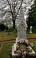
 Seat by the war memorial at East Wellow - geograph.org.uk - 4292971.jpg 640 × 480; 100 KB
-

-

-

-

-

-
 Test Valley UK Local Election 2023.svg 828 × 1,221; 475 KB
-
 The Big House (109125563).jpeg 2,048 × 2,048; 1.55 MB
-
 The Daffodil (109125611).jpeg 2,048 × 2,048; 1.9 MB
-
 The Flower (109125669).jpeg 2,048 × 2,048; 1.49 MB
-
 The Test Way adjacent to Monk's Cottages - geograph.org.uk - 3583587.jpg 640 × 482; 136 KB
-
 Weird tree Danebury Hill Fort - panoramio.jpg 2,626 × 2,129; 3.19 MB
-
 West Wellow Common - geograph.org.uk - 4698194.jpg 1,024 × 768; 212 KB
-
 West Wellow Common, ponies - geograph.org.uk - 4698248.jpg 1,024 × 768; 167 KB
-
 West Wellow Common, seat - geograph.org.uk - 4698225.jpg 1,024 × 768; 202 KB
-
 West Wellow Common, track - geograph.org.uk - 4698204.jpg 1,024 × 768; 204 KB
-
 West Wellow Common, trig point - geograph.org.uk - 4698240.jpg 1,024 × 768; 219 KB
-
 West Wellow, pond - geograph.org.uk - 4698214.jpg 1,024 × 768; 197 KB
-
 West Wellow, Red Rover - geograph.org.uk - 4698269.jpg 1,024 × 768; 173 KB
-
 West Wellow, restricted byway - geograph.org.uk - 4717541.jpg 1,024 × 768; 255 KB
-
 Woodside, Chilworth - geograph.org.uk - 802742.jpg 427 × 640; 187 KB
-
 Meadow Ditches near Mottisfont - geograph.org.uk - 425568.jpg 640 × 480; 130 KB
-
 Meadow near Mottisfont - geograph.org.uk - 425565.jpg 640 × 480; 102 KB
_-_geograph.org.uk_-_4292114.jpg)
_-_geograph.org.uk_-_4292115.jpg)
_-_geograph.org.uk_-_4292116.jpg)
_-_geograph.org.uk_-_4292117.jpg)
_-_geograph.org.uk_-_4293008.jpg)
_-_geograph.org.uk_-_4292972.jpg)
_-_geograph.org.uk_-_4292973.jpg)
_-_geograph.org.uk_-_4292988.jpg)
_-_geograph.org.uk_-_4292992.jpg)
_-_geograph.org.uk_-_4293009.jpg)


.jpg)


.jpg)


.jpeg)
.jpeg)
.jpeg)


.jpg)


.jpeg)
.jpeg)
.jpeg)


