Category:Moray Coast Railway
former railway line in Scotland | |||||
| Upload media | |||||
| Instance of | |||||
|---|---|---|---|---|---|
| Part of |
| ||||
| Location |
| ||||
| |||||
The Moray Coast Railway was a railway line running between Portsoy and Lossie, close to the coast of the Moray Firth, in the north of Scotland.
Subcategories
This category has the following 8 subcategories, out of 8 total.
B
- Buckpool railway station (2 F)
C
G
- Glassaugh railway station (3 F)
P
- Portessie railway station (3 F)
- Portsoy railway station (5 F)
S
- Spey Bay railway station (4 F)
- Spey Viaduct, Garmouth (24 F)
Media in category "Moray Coast Railway"
The following 14 files are in this category, out of 14 total.
-
 By the Dismantled Railway at Elgin - geograph.org.uk - 1458100.jpg 640 × 430; 67 KB
-
 Cullen station site geograph-3162613-by-Ben-Brooksbank.jpg 2,394 × 1,452; 3.13 MB
-
 Cycle Way - geograph.org.uk - 850273.jpg 640 × 427; 273 KB
-
 Dismantled Railway near Cullen - geograph.org.uk - 153181.jpg 640 × 480; 180 KB
-
 Dismantled Railway, Strathlene - geograph.org.uk - 279685.jpg 640 × 480; 71 KB
-
 Disused railway near Burghead - geograph.org.uk - 80560.jpg 640 × 427; 91 KB
-
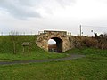
 Old Railway Bridge - geograph.org.uk - 1210310.jpg 640 × 480; 100 KB
-
 Old Railway Bridge, Garmouth - geograph.org.uk - 279705.jpg 640 × 480; 67 KB
-
 Old railway bridge, Lhanbryde.JPG 4,317 × 2,770; 8.32 MB
-
 Old railway cutting, Nether Dallachy, Spey Bay,.JPG 4,608 × 3,456; 6.64 MB
-
 Old railway trackbed, Urquhart, Moray.JPG 4,426 × 2,706; 4.65 MB
-
 Old railway, Nether Dallachy, Spey Bay, Scotland.JPG 4,554 × 3,384; 5.67 MB
-
 Urquhart road overbridge, Moray.JPG 4,232 × 2,744; 7.67 MB
-
 Urquhart station (remains) geograph-4045671-by-Ben-Brooksbank.jpg 2,396 × 1,456; 3.75 MB


_geograph-4045671-by-Ben-Brooksbank.jpg)