Category:NYPL maps of Staten Island
Subcategories
This category has the following 3 subcategories, out of 3 total.
Media in category "NYPL maps of Staten Island"
The following 24 files are in this category, out of 24 total.
-

-

-

-

-
-

-

-

-

-

-

-
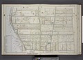
 Part of Ward 4. (Map bound by Jackson Ave, Lower Bay, New Dorp Lane, Richmond Road) NYPL1643840.tiff 7,230 × 5,166; 106.86 MB
-

-

-

-
 Part of Ward 5. (Map bound by Amboy Road, Beach St, Pier and Bulkhead Line) NYPL1643852.tiff 7,230 × 5,166; 106.86 MB
-

-
 Part of Ward 5. (Map bound by Old Pier and Bulkhead Line, Church St, Amboy Ave) NYPL1643853.tiff 7,230 × 5,166; 106.86 MB
-

-

-

-

-

-
