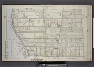
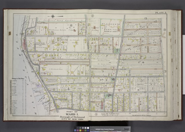
File:Part of Ward 1. (Map bound by Sailors Snug Harbor, Henderson Ave, Castleton Ave, Forest Ave, Broadway, Kill Van Kull) NYPL1643846.tiff

Size of this JPG preview of this TIF file: 800 × 572 pixels. Other resolutions: 320 × 229 pixels | 640 × 457 pixels | 1,024 × 732 pixels | 1,280 × 915 pixels | 2,560 × 1,829 pixels | 7,230 × 5,166 pixels.
Original file (7,230 × 5,166 pixels, file size: 106.86 MB, MIME type: image/tiff)
Captions
Captions
Add a one-line explanation of what this file represents
Summary
edit| Description | Part of Ward 1. [Map bound by Sailors Snug Harbor, Henderson Ave, Castleton Ave, Forest Ave, Broadway, Kill Van Kull]; Atlases of New York city. / Atlas of the borough of Richmond, city of New York. | |||||||||||||||||||||||
| Item/Page/Plate | Plate 3 | |||||||||||||||||||||||
| Date | Unknown date | |||||||||||||||||||||||
| Source |
http://digitalgallery.nypl.org/nypldigital/dgkeysearchdetail.cfm?imageID=1643846
|
|||||||||||||||||||||||
| Author | ||||||||||||||||||||||||
| Permission (Reusing this file) |
From The Lionel Pincus and Princess Firyal Map Division. http://maps.nypl.org
|
|||||||||||||||||||||||
| Location | Stephen A. Schwarzman Building / The Lionel Pincus and Princess Firyal Map Division | |||||||||||||||||||||||
| Digital item published | 8-6-2008; updated 3-25-2011 | |||||||||||||||||||||||
| Digital ID | 1643846 | |||||||||||||||||||||||

The making of this file was supported by Wikimedia UK.
To see other files made with the support of Wikimedia UK, please see the category Supported by Wikimedia UK.
|
File history
Click on a date/time to view the file as it appeared at that time.
| Date/Time | Thumbnail | Dimensions | User | Comment | |
|---|---|---|---|---|---|
| current | 10:24, 4 May 2014 |  | 7,230 × 5,166 (106.86 MB) | Fæ (talk | contribs) | GWToolset:: Creating mediafile for Fæ. Tranche 3 11591-16518 @ 2 May, 06:47 BST |
You cannot overwrite this file.
File usage on Commons
There are no pages that use this file.