Category:Nebraska Spur 16F
secondary state highway spur in Cherry County, Nebraska, United States   | |||||
| Upload media | |||||
| Instance of | |||||
|---|---|---|---|---|---|
| Location | Cherry County, Nebraska | ||||
| Transport network |
| ||||
| Owned by | |||||
| Maintained by | |||||
| Inception |
| ||||
| Length |
| ||||
| Terminus | |||||
| |||||
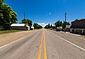
English: Media related to Nebraska Spur 16F, a 18.9-mile (30.4 km) secondary state highway spur in Cherry County, Nebraska, United States, that connects the Samuel R. McKelvie National Forest with U.S. Route 20 in Nenzel.
Subcategories
This category has only the following subcategory.
Media in category "Nebraska Spur 16F"
The following 4 files are in this category, out of 4 total.
-
 N SPUR 16F.svg 600 × 600; 10 KB
-
 Nenzel, NE.jpg 4,673 × 3,264; 1.96 MB
-
 Nenzel, Nebraska (9094900057).jpg 6,048 × 4,032; 3.53 MB
-
 Nenzel, Nebraska (9097134394).jpg 6,048 × 4,032; 3.4 MB
.jpg)
.jpg)