Category:Nederlands Hervormde Kerk, Hippolytushoef
| Object location | | View all coordinates using: OpenStreetMap |
|---|
church building in Hollands Kroon, Netherlands  | |||||
| Upload media | |||||
| Instance of | |||||
|---|---|---|---|---|---|
| Location | Hippolytushoef, Hollands Kroon, North Holland, Netherlands | ||||
| Street address |
| ||||
| Located on street |
| ||||
| Heritage designation |
| ||||
| official website | |||||
 | |||||
Toren:
|
This is a category about rijksmonument number 38920
|
Kerk:
|
This is a category about rijksmonument number 38921
|
| Address |
|
Media in category "Nederlands Hervormde Kerk, Hippolytushoef"
The following 33 files are in this category, out of 33 total.
-
 Achtergevel - Hippolytushoef - 20113679 - RCE.jpg 810 × 1,200; 208 KB
-
 Dierenbeeld Hippolytushoef.JPG 2,448 × 3,264; 2.6 MB
-
 Exterieur OVERICHT OOSTGEVEL - Hippolytushoef - 20263053 - RCE.jpg 804 × 1,200; 186 KB
-
 Exterieur OVERZICHT NOORDGEVEL - Hippolytushoef - 20263052 - RCE.jpg 789 × 1,200; 177 KB
-
 Exterieur TOREN, SPITS - Hippolytushoef - 20263054 - RCE.jpg 802 × 1,200; 171 KB
-
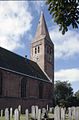
 Exterieur vanuit het westen - Hippolytushoef - 20113621 - RCE.jpg 940 × 1,200; 192 KB
-
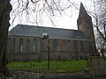
 Exterieur vanuit het zuid-oosten - Hippolytushoef - 20113620 - RCE.jpg 825 × 1,200; 211 KB
-
 Herenbank Hippolytuskerk, Hippolytushoef.jpg 5,472 × 3,648; 5.28 MB
-
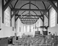
 Interieur naar het oosten - Hippolytushoef - 20113627 - RCE.jpg 954 × 1,200; 212 KB
-
 Interieur naar het oosten - Hippolytushoef - 20113637 - RCE.jpg 1,200 × 960; 190 KB
-
 Interieur naar het westen - Hippolytushoef - 20113626 - RCE.jpg 958 × 1,200; 231 KB
-
 Interieur naar het westen - Hippolytushoef - 20113638 - RCE.jpg 1,200 × 953; 188 KB
-
 Interieur, aanzicht orgel, orgelnummer 694 - Hippolytushoef - 20369321 - RCE.jpg 807 × 1,200; 161 KB
-
 Koor vanuit het zuid-oosten - Hippolytushoef - 20113622 - RCE.jpg 958 × 1,200; 334 KB
-
 NH Kerk Hippolytushoef.JPG 3,648 × 2,736; 5.63 MB
-
 Noordgevel - Hippolytushoef - 20113632 - RCE.jpg 1,200 × 948; 337 KB
-
 Oostgevel - Hippolytushoef - 20113633 - RCE.jpg 951 × 1,200; 288 KB
-
 Orgel - Hippolytushoef - 20113640 - RCE.jpg 953 × 1,200; 182 KB
-
 Orgel Hippolytuskerk, Hippolytushoef.jpg 5,472 × 3,648; 5.39 MB
-
 Overzicht - Hippolytushoef - 20113630 - RCE.jpg 967 × 1,200; 266 KB
-
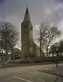 Overzicht toren hervormde kerk - Hippolytushoef - 20396635 - RCE.jpg 926 × 1,200; 268 KB
-

-
-
 Preekstoel met doophek - Hippolytushoef - 20113639 - RCE.jpg 960 × 1,200; 150 KB
-
 Raam met roestende brugijzers - Hippolytushoef - 20113623 - RCE.jpg 961 × 1,200; 429 KB
-
 Raam met roestende brugijzers - Hippolytushoef - 20113624 - RCE.jpg 951 × 1,200; 154 KB
-
 Raam met roestende brugijzers - Hippolytushoef - 20113625 - RCE.jpg 967 × 1,200; 148 KB
-
 Rijksmonument-38920-20111103094338.jpg 2,048 × 1,536; 897 KB
-
 Stedenraam Hippolytuskerk, Hippolytushoef.jpg 3,555 × 5,333; 2.89 MB
-
 Stenen spits, detail - Hippolytushoef - 20113636 - RCE.jpg 1,200 × 1,200; 196 KB
-
 Stenen torenspits vanuit het noord-oosten - Hippolytushoef - 20113635 - RCE.jpg 1,188 × 1,200; 239 KB
-
 Westgevel toren - Hippolytushoef - 20113631 - RCE.jpg 955 × 1,200; 353 KB
-
 Zuid-oost gevel - Hippolytushoef - 20113634 - RCE.jpg 1,200 × 960; 399 KB


