Category:Nederlands Hervormde Kerk, Zaamslag
| Object location | | View all coordinates using: OpenStreetMap |
|---|
church in Zaamslag, Netherlands  | |||||
| Upload media | |||||
| Instance of | |||||
|---|---|---|---|---|---|
| Location | Zaamslag, Zeeland, Netherlands | ||||
| Street address |
| ||||
| Has part(s) | |||||
| Inception |
| ||||
 | |||||
Nederlands: Ned. Hervormde Kerk Zaamslag - anno 1899
|
This is a category about rijksmonument number 35026
|
|
This is a category about a municipal monument in Terneuzen with number WN135 |
| Address |
|
Media in category "Nederlands Hervormde Kerk, Zaamslag"
The following 8 files are in this category, out of 8 total.
-
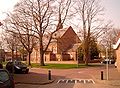 Dorpsplein Zaamslag.jpg 1,996 × 1,471; 1.39 MB
-
 Interieur, aanzicht orgel, orgelnummer 1727 - Zaamslag - 20369448 - RCE.jpg 858 × 1,200; 187 KB
-
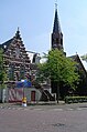
 Overzicht noordwestgevel met kerktoren - Zaamslag - 20352933 - RCE.jpg 956 × 1,200; 232 KB
-

-
 Plein Zaamslag.JPG 258 × 389; 35 KB
-
 Preekstoel - Zaamslag - 20218626 - RCE.jpg 947 × 1,200; 177 KB
-
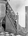 Preekstoel, leuning - Zaamslag - 20218625 - RCE.jpg 938 × 1,200; 187 KB
-
 Zaamslag - Church PKN 1.jpg 1,728 × 2,304; 997 KB


