Category:Old maps of Denver, Colorado
Subcategories
This category has the following 4 subcategories, out of 4 total.
Media in category "Old maps of Denver, Colorado"
The following 17 files are in this category, out of 17 total.
-
-
 Cheesman Park showing planting around memorial - DPLA - c867391d5e1da22c92e0ace7b3570be6.jpg 7,276 × 4,644; 2.75 MB
-
 Copy of map - DPLA - 9f27b16009961215b607a0e49557177a.jpg 4,403 × 5,000; 2.56 MB
-
 Denver City Park. - DPLA - 1ddf8e8d6285e916a5fd7a22490f9852.jpg 9,000 × 4,894; 7.01 MB
-
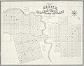
 Denver, Colorado - DPLA - af0960215c2f4b3f723b26ee90def205.jpg 9,000 × 7,847; 10.22 MB
-
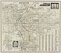
 Denver, Colorado - DPLA - f3741ef4773d302b9619c43bda7aac1b.jpg 9,000 × 7,999; 9.86 MB
-
 Downington, Denver, Colo. - DPLA - 0bf54a7c4a1c3f32d5141e5ece2eac51.jpg 5,341 × 8,320; 5.36 MB
-
 Downington, Denver, Colo. - DPLA - 459256d82c578fb3e33dff7e6bfd8bc5.jpg 5,063 × 8,010; 4.29 MB
-
 Fairmount Cemetery, Denver, Colorado - DPLA - 1323847dc15b1c932ea742e38746d4fa.jpg 8,741 × 8,999; 15.53 MB
-
 Map of Cheesman Park and Mt. Calvary Cemetery - DPLA - 116461882262f6e96c7df0b624af5cdc.jpg 8,097 × 5,237; 5.38 MB
-
 Ninth Street Historic District Planting Plan - DPLA - c7b7fa23ee278e0c353d6a781a56e2ad.jpg 8,999 × 6,117; 4.71 MB
-

-
 Plat of Barnum - DPLA - 8a432735b6fa9dcbfe14c8c55c75e2ce.jpg 8,695 × 9,000; 12.16 MB
-
 Skyline Project area land use map - DPLA - e6d686a6f308b63078ed794c5c5ebc37.jpg 8,999 × 6,758; 17.16 MB
-
 Tivoli Block 11 Map - DPLA - 72acd20c13071d02b67af7eedc721e4b.jpg 5,864 × 9,000; 5.13 MB
-
 Villa Park Map - DPLA - 649bc9aa2905dd36fa5e0401f4902479.jpg 3,895 × 2,454; 880 KB
-
 Villa Park Map - DPLA - 700c7d16dde552d88b7dcfddc58fd3fb.jpg 3,895 × 2,454; 1.04 MB


_for_Montview_Boulevard_-_DPLA_-_71b67529e75771312f4b8efb4c360af7.jpg)


