Category:Old maps of Great Britain
Austrian Empire · Austria-Hungary · Great Britain · British Empire · Byzantine Empire · Carolingian Empire · Republic of Genoa · Habsburg Monarchy · Holy Roman Empire · Polish-Lithuanian Commonwealth · Ottoman Empire · Prussia · Grand Duchy of Moscow · Tsardom of Russia · Russian Empire · Soviet Union · Spanish Empire ·
Old maps of Great Britain.
Subcategories
This category has the following 12 subcategories, out of 12 total.
Media in category "Old maps of Great Britain"
The following 39 files are in this category, out of 39 total.
-
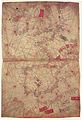
 Map of Britain (c.1250) - Matthew Paris, Historia Anglorum, f. 5v.jpg 1,134 × 1,500; 549 KB
-
 Map of Britain (c.1250) - Matthew Paris - STC255189.jpg 281 × 400; 39 KB
-

-
 Britannienkarte des Matthew Paris.jpg 2,982 × 4,000; 4.58 MB
-

-
-
 Situasjonen i Nord-Europa 1801.jpg 5,500 × 2,953; 19.35 MB
-
-
 Moon-type-map.jpg 1,210 × 2,307; 439 KB
-

-
 Public Schools Historical Atlas - England France 1152-1327.jpg 894 × 1,168; 321 KB
-
 Public Schools Historical Atlas - England France Henry I.jpg 863 × 1,116; 305 KB
-
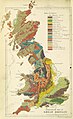
 Agricultural Map of Great Britain.jpg 25,014 × 38,998; 153.87 MB
-

-
 25 of 'Key Index to the Cyclists' Pocket Road Guides, etc' (11165763963).jpg 2,064 × 1,217; 568 KB
-

-
-
 Admiralty Chart No 2 The British Islands, Published 1913 02.jpg 8,616 × 12,553; 10.08 MB
-
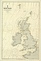 Admiralty Chart No 2 The British Islands, Published 1913.jpg 8,315 × 12,302; 11.98 MB
-
 Ancient-map-of-Britain.jpg 595 × 890; 59 KB
-
-
 Atlantic map from Pietro Vesconte 1321 atlas.jpg 1,007 × 1,478; 533 KB
-
 Atlantic map from Pietro Vesconte 1325 atlas.jpg 1,954 × 2,848; 2.65 MB
-
 Britain in AD500 - Project Gutenberg eText 16790.jpg 606 × 1,000; 102 KB
-
 British Empire throughout the world exhibited in one view. LOC 98687124.jpg 6,720 × 5,608; 6.57 MB
-
 British Empire throughout the world exhibited in one view. LOC 98687124.tif 6,720 × 5,608; 107.82 MB
-

-
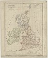
 England 1828.jpg 5,416 × 6,697; 7.4 MB
-
-
 Map of Britannia Wellcome L0051170.jpg 4,464 × 6,626; 11.19 MB
-
 Map of principal Mesolithic sites in Britain. Wellcome M0016326.jpg 2,598 × 4,120; 1,015 KB
-
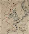
 Maps illustrating cruises of John Paul Jones in British waters (10175546456).jpg 4,029 × 5,175; 3.86 MB
-
 Nordenskiöld 1897 Plate 32 Tabula Regionum Septentrionalium !5th Century.jpg 7,341 × 5,498; 9.44 MB
-

-
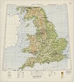
 Ordnance Survey Agricultural Map of Great Britain Sheet 1, North, Published 1942.jpg 25,014 × 19,441; 45.68 MB
-
 Ordnance Survey Agricultural Map of Great Britain Sheet 2, South, Published 1942.jpg 25,014 × 19,597; 48.32 MB
-
 Ordnance Survey Great Britain Sheet 1, Published 1933.jpg 11,753 × 13,696; 37.51 MB
-
 Ordnance Survey Great Britain Sheet 2, Published 1933.jpg 12,412 × 13,632; 40.67 MB
-
 ShepardMap802Northumbria.png 650 × 834; 359 KB
_-_Matthew_Paris,_Historia_Anglorum,_f._5v.jpg)
_-_Matthew_Paris_-_STC255189.jpg)
_-_Matthew_Paris,_Chronica_Maiora_part_2,_fol_iv_verso.jpg)

,_f._187v.jpg)
.jpg)


.jpg)


.jpg)
.jpg)
.jpg)
%27_(11067963895).jpg)


_(18016116618).jpg)


.jpg)

.jpg)


