Category:Old maps of Wales
Constituent countries of the United Kingdom: England · Northern Ireland · Scotland · Wales – British Crown dependencies: Bailiwick of Guernsey · Isle of Man · Jersey
British overseas territories: Bermuda · Falkland Islands · Gibraltar · Pitcairn Islands · South Georgia and the South Sandwich Islands
British overseas territories: Bermuda · Falkland Islands · Gibraltar · Pitcairn Islands · South Georgia and the South Sandwich Islands
Use the appropriate category for maps showing all or a large part of Wales. See subcategories for smaller areas:
| If the map shows | Category to use |
|---|---|
| Wales on a recently created map | Category:Maps of Wales or its subcategories |
| Wales on a map created more than 70 years ago | Category:Old maps of Wales or its subcategories |
| the history of Wales on a recently created map | Category:Maps of the history of Wales or its subcategories |
| the history of Wales on a map created more than 70 years ago | Category:Old maps of the history of Wales or its subcategories |
Subcategories
This category has the following 21 subcategories, out of 21 total.
Media in category "Old maps of Wales"
The following 30 files are in this category, out of 30 total.
-

-

-
 55 of 'Hartley's illustrated coaching guide to North Wales' (11202381105).jpg 1,952 × 1,317; 798 KB
-
 A map of Ireland Wellcome V0049913.jpg 3,313 × 2,475; 4.08 MB
-
 A short history of England and the British Empire (1915) (14580879807).jpg 1,996 × 2,720; 818 KB
-
 Accuratissima Angliae regni et Walliae principatus descriptio - CBT 6604533.jpg 5,106 × 4,749; 8.66 MB
-

-
 Bacon's Map of Wales, from the ordnance surveys - by Edw. Weller... - btv1b53022852h.jpg 8,639 × 10,680; 17.18 MB
-
 Caermardi Comitatus in Quo Dimetae olim habitarunt.jpg 2,732 × 2,315; 2.01 MB
-
 Dyfi Hills.svg 512 × 510; 6.5 MB
-
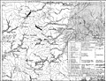
 EB1911 Water Supply - Welsh Reservoir Sites (bottom).jpg 2,716 × 2,082; 1.54 MB
-
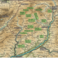
 EB1911 Water Supply - Welsh Reservoir Sites (top).jpg 2,704 × 2,062; 1.75 MB
-
 England 1828.jpg 5,416 × 6,697; 7.4 MB
-
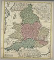
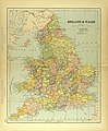
 England Und Wales.jpg 5,656 × 4,548; 7.97 MB
-
 England und Wales.jpg 5,636 × 4,587; 8.07 MB
-
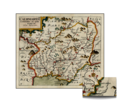
 Galles. Monmouth. Carte. Morden.jpg 509 × 391; 103 KB
-
 Llangennech Caermardi Map.png 2,732 × 2,315; 6.45 MB
-
-
 Map c1577.jpg 2,619 × 2,139; 947 KB
-
 MAp Hugh.PNG 711 × 751; 1,014 KB
-
 Map of England and Wales Wellcome V0049911.jpg 2,494 × 2,815; 3.25 MB
-
 Map of England and Wales.jpg 2,931 × 3,542; 2.37 MB
-
 Map Sampler (Wales), 18th century (CH 18564361).jpg 4,096 × 2,959; 13.08 MB
-
 The south part of Great Britain, called England and Wales (NYPL b15369994-1630442).tiff 7,230 × 5,256; 108.72 MB
-

-
 OS old series 1 63360 36.jpg 9,047 × 6,137; 14.2 MB
-
 OS old series 1 63360 41.jpg 8,954 × 6,325; 14.22 MB
-
 Powys.png 844 × 925; 31 KB
-
 Verwaltungskarte von England 02.jpg 5,249 × 4,407; 8.35 MB
-
 Wenceslas Hollar - South Wales.jpg 3,513 × 2,404; 2.78 MB
.jpg)
._30_illustrations%27_(11195985615).jpg)
.jpg)

_(14580879807).jpg)


.jpg)
.jpg)


,_18th_century_(CH_18564361).jpg)
.jpg)


