Category:Old maps of Maharashtra
States of India: Andhra Pradesh · Arunachal Pradesh · Assam · Bihar · Goa · Gujarat · Jharkhand · Karnataka · Kerala · Madhya Pradesh · Maharashtra · Manipur · Meghalaya · Odisha · Sikkim · Tamil Nadu · Telangana · Tripura · Uttar Pradesh · Uttarakhand · West Bengal
Union territories: Andaman and Nicobar Islands · Dadra and Nagar Haveli and Daman and Diu · Delhi · Jammu and Kashmir · Ladakh · Lakshadweep · Puducherry
Former states of India: Jammu and Kashmir ·
Former union territories: Daman and Diu ·
Union territories: Andaman and Nicobar Islands · Dadra and Nagar Haveli and Daman and Diu · Delhi · Jammu and Kashmir · Ladakh · Lakshadweep · Puducherry
Former states of India: Jammu and Kashmir ·
Former union territories: Daman and Diu ·
Subcategories
This category has the following 2 subcategories, out of 2 total.
O
Media in category "Old maps of Maharashtra"
The following 51 files are in this category, out of 51 total.
-

-
 ... map of Harishchandragad (6841471361).jpg 4,000 × 2,672; 4.33 MB
-

-
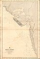
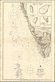 Admiralty Chart No 827 Vengurla to Cape Comorin, Published 1877, New Edition 1914.jpg 10,881 × 16,191; 50.36 MB
-
 Admiralty Chart No 827 Vengurla to Cape Comorin, Published 1877.jpg 10,542 × 16,083; 51.21 MB
-
 Kalyan 1955.jpg 1,004 × 655; 204 KB
-

-

-
 Admiralty Chart No 739 Boria Pagoda to Malvan, Published 1912.jpg 11,280 × 18,426; 58.42 MB
-
-
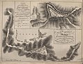
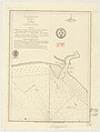 Admiralty Chart No 778 Danno River, Published 1787.jpg 4,122 × 5,470; 5.12 MB
-
 Admiralty Chart No 779 Angassea River and Island Arnol, with Views, Published 1784.jpg 8,376 × 5,394; 11.25 MB
-
 Admiralty Chart No 782 Bombay to Carwar Head, Published 1791.jpg 7,206 × 8,758; 9.37 MB
-
 Admiralty Chart No 785 Chaoul Port, with Views, Published 1784.jpg 8,066 × 5,442; 9.18 MB
-
 Admiralty Chart No 788 Bancoot River Entrance, with a View, Published 1789.jpg 6,004 × 5,368; 7.95 MB
-
 Admiralty Chart No 790 Dewgur Harbour with a View, Published 1784.jpg 6,874 × 5,386; 3.72 MB
-
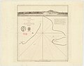
 Admiralty Chart No 791 Sinderdroo or Melundy Roads, with View, Published 1774.jpg 4,110 × 5,340; 5.28 MB
-

-
 Admiralty Chart No 826 Karachi to Vengurla, Published 1877.jpg 10,907 × 15,966; 56.67 MB
-
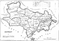
 Ahmednagar 1896.jpg 2,048 × 1,302; 678 KB
-
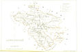
 AkalkotKart.jpg 237 × 242; 87 KB
-
 Alibag 1896.jpg 1,649 × 2,745; 749 KB
-
 City of Solapur 2.jpg 1,674 × 2,620; 993 KB
-
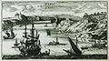 Dabul int ryck vanden Grooten Mogol en Indien - Peeters Jacob - 1690.jpg 1,500 × 842; 903 KB
-
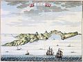
 Dabul. in Prévost. 1750.jpg 3,257 × 2,805; 847 KB
-
 Dabul1752.jpg 1,075 × 805; 190 KB
-
 Dabulview.jpg 750 × 600; 102 KB
-
 EstadoInd.jpg 329 × 575; 53 KB
-

-
 Hyderabad and Berar 1903.jpg 640 × 480; 179 KB
-
 Kalyan 1883.jpg 4,624 × 3,936; 2.7 MB
-
 KhandeshDistrict-1878.png 1,546 × 1,079; 742 KB
-
 Mahabaleshwar 1855.jpg 2,452 × 1,704; 2.49 MB
-
 Mahabaleshwar Map.jpg 1,002 × 786; 344 KB
-
 Mahabaleshwar1924.jpg 571 × 955; 62 KB
-
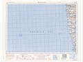 Map India and Pakistan 1-250,000 Tile NE 43-13 Ratnagiri.jpg 5,000 × 3,690; 2.38 MB
-
 Matheran India Map 1911.jpg 1,268 × 1,942; 261 KB
-
 Matheran1924.jpg 931 × 1,321; 258 KB
-
 Plan of Matheran 1896.jpg 1,674 × 2,675; 1.69 MB
-
 Plan of Wassota and Sattara, 1818.jpg 1,519 × 1,177; 320 KB
-
 Pope1880BombayPres2.jpg 929 × 1,200; 235 KB
-
 Ratnagiri 1880.png 1,606 × 2,370; 2.08 MB
-
 Ratnagiri Fort and City map.jpg 2,656 × 1,674; 1.11 MB
-
 Ratnagiri Town 1896 map.jpg 1,212 × 1,581; 452 KB
-

-
 Solapur 1896.jpg 1,674 × 2,620; 672 KB
-
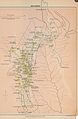
 Solapur district 1896.jpg 2,048 × 1,309; 994 KB
-
 Thane district 1896.jpg 1,723 × 2,726; 1.07 MB
-
 The Abhiras at their maximum extent.png 836 × 900; 278 KB
-
 United Maharashtra, Conceptual map.jpg 4,237 × 3,045; 2.36 MB
-
 Zdabul.jpg 774 × 546; 145 KB

.jpg)


%27_(11091469594).jpg)
%27_(11093105786).jpg)


