Category:Old maps of Piedmont
- Regions of Italy: Abruzzo · Aosta Valley · Apulia · Basilicata · Calabria · Campania · Emilia-Romagna · Friuli-Venezia Giulia · Lazio · Liguria · Lombardy · Marche · Molise · Piedmont · Sardinia · Sicily · Trentino-South Tyrol · Tuscany · Umbria · Veneto
Use the appropriate category for maps showing all or a large part of Piedmont. See subcategories for smaller areas:
| If the map shows | Category to use |
|---|---|
| Piedmont on a recently created map | Category:Maps of Piedmont or its subcategories |
| Piedmont on a map created more than 70 years ago | Category:Old maps of Piedmont or its subcategories |
| the history of Piedmont on a recently created map | Category:Maps of the history of Piedmont or its subcategories |
| the history of Piedmont on a map created more than 70 years ago | Category:Old maps of the history of Piedmont or its subcategories |
Subcategories
This category has the following 13 subcategories, out of 13 total.
- 19th-century maps of Piedmont (18 F)
A
- Atlante Vallardi - Piemonte (12 F)
I
M
N
- Old maps of Novara (3 F)
T
- Old maps of Turin (58 F)
Media in category "Old maps of Piedmont"
The following 71 files are in this category, out of 71 total.
-
 10417 - Waldensian - Map of the Waldensian Valley.jpg 2,749 × 2,167; 1.54 MB
-
-

-

-
 129 of 'La France Illustrée- géographie générale ... Par F. J' (11292559636).jpg 1,073 × 1,040; 415 KB
-
 Turin - 25-45.jpg 3,616 × 5,037; 3.44 MB
-
 Ciriè.jpg 3,198 × 3,331; 9.1 MB
-
 Ivrea.jpg 3,401 × 3,367; 12.67 MB
-
 Gran Paradiso-G.jpg 3,424 × 3,329; 11.98 MB
-
 247 of 'The Campaign of Marengo. With comments' (11240033645).jpg 2,668 × 2,211; 1.05 MB
-

-
 9 of 'Viaggi in Italia. (With plates, including maps.)' (11008370094).jpg 4,104 × 4,397; 4.71 MB
-

-
 Atlas Van der Hagen-KW1049B12 059-SIGNORIA di VERCELLI.jpeg 5,500 × 4,604; 3.51 MB
-

-
 Bulletin de la Societe Belge de Geologie, de Paleontologie et d'Hydrologie (20248843389).jpg 2,096 × 3,510; 2.02 MB
-
 Canton d'Oulx (département du Po).jpg 1,177 × 811; 1.45 MB
-
 Canton de Césanne (département du Po).jpg 1,071 × 726; 1.02 MB
-

-
 CartaSavoia.jpg 461 × 608; 85 KB
-
 CarteEM couleur.jpg 1,981 × 2,436; 678 KB
-

-

-

-

-

-
 D609 - N° 315. Vallées Vaudoises. -liv3-ch6.png 1,462 × 1,336; 426 KB
-
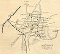 Derthona.jpg 2,734 × 2,476; 8.99 MB
-
 Divisione militare di Novara. Provincie di Valsesia e di Vercelli.jpg 3,206 × 4,612; 9.35 MB
-
 Divisione militare di Torino. Provincia di Torino.jpg 4,728 × 3,261; 9.02 MB
-

-
-
 DufourCravariola1875.png 1,005 × 609; 1.34 MB
-
 DufourCravariola1876.png 1,006 × 607; 1.27 MB
-
 El Piamonte - btv1b53042344q.jpg 6,025 × 7,815; 6.37 MB
-
 El Piamonte, cum Privilegio - btv1b8494713t.jpg 6,140 × 8,177; 7.89 MB
-

-
 Felizzano XVII secolo.jpg 573 × 845; 222 KB
-

-

-

-

-

-
 Map - Special Collections University of Amsterdam - OTM- HB-KZL 31-28-56.tif 6,298 × 7,317; 131.84 MB
-
 Map italy monferrato CG 34 PEDEMONTIUM.jpg 5,436 × 4,254; 5.93 MB
-

-
 Map italy monferrato CG 37 CARTA GEOGRAFICA DELLO STATO DEL PIEMONTE.jpg 5,907 × 4,488; 12.37 MB
-
 Map italy monferrato CG 38 KINGDOM OF SARDINIA.jpg 12,931 × 11,340; 45.75 MB
-
 Map italy monferrato CG 39 PARTE DEL PIEMONTE IL DISTRETTO DI TORINO LA LUMELLINA IL PAVESE.jpg 12,107 × 8,976; 24.05 MB
-
 Map italy monferrato CG 52 montiferrati ducatus post 1684.jpg 14,549 × 11,812; 52.15 MB
-

-
 Map of the Duchy of Piedmont by Abraham Ortelius.jpeg 1,582 × 1,181; 640 KB
-
 Mappa del ducato del Monferrato.jpg 2,414 × 1,896; 1.02 MB
-
 Mappa del ducato di Milano e sue pertinenze.jpg 2,426 × 1,776; 1.15 MB
-
 Mappa fine xviii sec alessandria.jpg 800 × 581; 127 KB
-
 Nova et accurata descriptio Delphinatus vulgo Dauphine (8343183618).jpg 800 × 663; 132 KB
-
 Ducatus Sabaudia Principatus Pedemontium .. (NYPL b13967336-5206887).tiff 10,326 × 7,758, 2 pages; 229.46 MB
-
-

-
 Piedmont 2.jpg 4,342 × 3,206; 12.64 MB
-
 Pignerol, Veüe de Verüe Ville de Piemont Située prés de la Riviere du Po (cropped).jpg 3,190 × 2,249; 1.72 MB
-
 Ponti e strade. Carta itineraria della provincia di Torino.jpg 4,125 × 2,950; 7.27 MB
-
 Solomiac (Département du Po).jpg 1,151 × 677; 1.07 MB
-
 Tabula generalis Sabaudiae (8342676279).jpg 800 × 658; 203 KB
-
 Liberazione di Torino, 7 settembre 1705.jpg 350 × 370; 42 KB
-
 UBBasel Map 1556 Kartenslg AA 70 Piamonte.tiff 12,062 × 9,700, 2 pages; 334.77 MB
-
 Vallardi - Torino, Cuneo, Novara, Alessandria e Pavia.jpg 2,889 × 3,529; 8.12 MB
-
 Veduta di Torino.jpg 3,238 × 3,519; 9.99 MB
-
 Verue, Veüe de Verüe Ville de Piemont Située prés de la Riviere du Po (cropped).jpg 3,104 × 2,270; 1.71 MB
-
 Veüe de Verüe Ville de Piemont Située prés de la Riviere du Po.jpg 9,187 × 6,759; 11.87 MB
-
 Walser Italien.JPG 1,968 × 2,121; 918 KB


_41.jpg)
_-_Geographicus_-_Germaniae-covensmortier-1720.jpg)
.jpg)


.jpg)
.jpg)
%27_(11008370094).jpg)


.jpg)
.jpg)
.jpg)


.jpg)
.jpg)
.jpg)


,_BI-B-FM-090-212.jpg)
,_RP-P-1939-1447.jpg)


.jpg)

.jpg)

.jpg)

.jpg)
.jpg)


.jpg)

