Category:Onecote
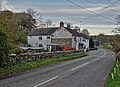
English: Onecote is a village and civil parish on the B5053 road, near Leek, in the Staffordshire Moorlands district, in the county of Staffordshire, England. Onecote has a church called St Luke's Church. (→Onecote)
Español: Onecote es una parroquia civil y un pueblo del distrito de Staffordshire Moorlands, en el condado de Staffordshire (Inglaterra). (→Onecote)
Nederlands: Onecote is een plaats en civil parish in het bestuurlijke gebied Staffordshire Moorlands, in het Engelse graafschap Staffordshire. In 2001 telde het dorp 224 inwoners. (→Onecote)
Polski: Onecote – wieś i civil parish w Anglii, w Staffordshire, w dystrykcie Staffordshire Moorlands. W 2011 civil parish liczyła 220 mieszkańców. (→Onecote)
Simple English: Onecote is a village and civil parish in Staffordshire Moorlands, Staffordshire, England. In 2001 there were 224 people living in Onecote. (→Onecote)

village and civil parish in Staffordshire, UK  | |||||
| Upload media | |||||
| Instance of | |||||
|---|---|---|---|---|---|
| Location | Staffordshire Moorlands, Staffordshire, West Midlands, England | ||||
| Population |
| ||||
| Said to be the same as | Onecote (Wikimedia duplicated page, civil parish) | ||||
 | |||||
Media in category "Onecote"
The following 138 files are in this category, out of 138 total.
-
 "The Jervis Arms", Onecote - geograph.org.uk - 6308564.jpg 4,923 × 3,552; 4.47 MB
-
 A clever piece of signage - geograph.org.uk - 4182620.jpg 800 × 600; 101 KB
-
-
 A narrowboat at Cross Ways Farm - geograph.org.uk - 4438059.jpg 1,200 × 900; 126 KB
-
 A wet Wetley Lane south of Onecote - geograph.org.uk - 6308558.jpg 3,888 × 5,184; 7.07 MB
-
 After the sale - Westbrook Head - geograph.org.uk - 456709.jpg 640 × 427; 128 KB
-
 Ancient milestone at the junction - geograph.org.uk - 3005450.jpg 612 × 816; 324 KB
-
 Approaching Onecote - geograph.org.uk - 6223810.jpg 1,067 × 1,600; 414 KB
-
 At Mixon - junction of tracks - geograph.org.uk - 6308136.jpg 5,184 × 3,888; 4.55 MB
-
 Bags of silage at roadside - geograph.org.uk - 4459355.jpg 4,320 × 3,240; 3.57 MB
-

-
 Benchmark on stone near New Mixon Hay - geograph.org.uk - 3005420.jpg 857 × 1,142; 304 KB
-
 Blackshaw Moor - geograph.org.uk - 5072387.jpg 5,025 × 3,118; 1.73 MB
-
 Blackshaw Moor - geograph.org.uk - 5082147.jpg 5,184 × 2,951; 1.84 MB
-
 Blakemere House - geograph.org.uk - 5082134.jpg 5,162 × 3,027; 2.03 MB
-
 Bridge and Public House in Onecote - geograph.org.uk - 2650898.jpg 3,296 × 2,472; 1.08 MB
-
 Building at Mixon's former copper mine - geograph.org.uk - 6308172.jpg 5,004 × 3,599; 4.73 MB
-
 Chapel House Farm, Onecote - geograph.org.uk - 941293.jpg 640 × 480; 63 KB
-
 Covered reservoir near Moor Top - geograph.org.uk - 6128138.jpg 1,600 × 1,067; 339 KB
-
 Douse Lane crosses Blakelow Road - geograph.org.uk - 3005452.jpg 1,306 × 979; 325 KB
-
 Douse Lane, Onecote - geograph.org.uk - 6223823.jpg 1,600 × 1,067; 252 KB
-
 Dunlea Farm outbuildings and silage store - geograph.org.uk - 3005406.jpg 1,142 × 857; 364 KB
-
 Dyking, Morridge - geograph.org.uk - 851492.jpg 640 × 480; 65 KB
-
 Fair View - geograph.org.uk - 4459331.jpg 4,250 × 3,144; 4.85 MB
-
 Farm access track, Onecote - geograph.org.uk - 455655.jpg 640 × 427; 135 KB
-
 Feltysitch farm - geograph.org.uk - 4023207.jpg 1,024 × 649; 140 KB
-
 Field barn on the Morridge - geograph.org.uk - 1311441.jpg 640 × 427; 73 KB
-
 Field barns near Ford - geograph.org.uk - 2367807.jpg 640 × 428; 226 KB
-
 Fingerpost by a gate - geograph.org.uk - 6128143.jpg 1,600 × 1,066; 227 KB
-
 Footbridge crossing the Hamps - geograph.org.uk - 2515511.jpg 3,648 × 2,736; 5.97 MB
-
 Footbridge over The River Hamps - geograph.org.uk - 6308570.jpg 3,888 × 5,184; 6.58 MB
-
 Footbridge over the upper Hamps - geograph.org.uk - 3005404.jpg 1,142 × 857; 430 KB
-
 Ford at Lower Green Farm - geograph.org.uk - 4413053.jpg 3,872 × 2,592; 4.69 MB
-
 Ford by Lower Green Farm - geograph.org.uk - 4023270.jpg 1,024 × 750; 270 KB
-
 Former Ford at Onecote - geograph.org.uk - 5095148.jpg 1,440 × 960; 2.29 MB
-
 Former post office and Blacksmith Forge, Onecote - geograph.org.uk - 6548049.jpg 2,000 × 1,333; 1.95 MB
-
 Former reservoir embankment - geograph.org.uk - 2515502.jpg 3,648 × 2,736; 5.74 MB
-
 Hamps valley farmland - geograph.org.uk - 4023282.jpg 1,024 × 777; 205 KB
-
 Hamps valley farmland scene - geograph.org.uk - 4023307.jpg 1,024 × 673; 140 KB
-
 Hamps Way - geograph.org.uk - 4178600.jpg 4,000 × 2,248; 5.7 MB
-
 Hamps Way leading out of Ford - geograph.org.uk - 4178510.jpg 3,970 × 2,194; 5.96 MB
-
 Hayfields above Harvey Gate - geograph.org.uk - 3005403.jpg 1,142 × 857; 346 KB
-
 Hazy view to Blackshaw Moor - geograph.org.uk - 2353008.jpg 2,918 × 2,035; 890 KB
-
 Herdwick ram - geograph.org.uk - 2354185.jpg 3,648 × 2,736; 5.5 MB
-
 Highmoor Farm - geograph.org.uk - 2354179.jpg 3,648 × 2,736; 4.39 MB
-
 In Onecote looking to St Luke's Church - geograph.org.uk - 6308163.jpg 3,791 × 5,055; 4.31 MB
-
 Information overload in Onecote - geograph.org.uk - 2515345.jpg 3,648 × 2,736; 5.73 MB
-
 Junction on Blakelow Road - geograph.org.uk - 6128140.jpg 1,600 × 1,066; 236 KB
-
 Lone tree and moorland - geograph.org.uk - 4459381.jpg 4,320 × 3,240; 4.77 MB
-
 Lonesome hawthorn - geograph.org.uk - 2353020.jpg 3,648 × 2,736; 4.98 MB
-
 Manor Farm across the Hamps valley - geograph.org.uk - 4023293.jpg 1,024 × 752; 136 KB
-
 Mill Lea near Onecote - geograph.org.uk - 6308122.jpg 5,139 × 3,712; 4.79 MB
-
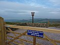
 Millennium Beacon at the former Mermaid Inn - geograph.org.uk - 4889522.jpg 799 × 1,200; 283 KB
-
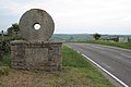 Millstone Boundary marker - geograph.org.uk - 455636.jpg 640 × 427; 120 KB
-
 Moorland junction - geograph.org.uk - 4459368.jpg 4,320 × 3,240; 3.92 MB
-
 Moorland pasture on Morridge - geograph.org.uk - 455627.jpg 640 × 427; 112 KB
-
 Moorland road - geograph.org.uk - 4459407.jpg 4,320 × 3,240; 4.71 MB
-
 Morridge, cattle grazing - geograph.org.uk - 4688501.jpg 1,024 × 768; 123 KB
-
 Mowing grass field, Onecote - geograph.org.uk - 2515336.jpg 3,648 × 2,736; 5.52 MB
-
 New Mixon Hay farm - geograph.org.uk - 3005408.jpg 1,142 × 857; 337 KB
-
 Newhouse Farm - geograph.org.uk - 4182609.jpg 800 × 600; 182 KB
-
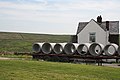
 Newhouse Farm and traditional oak products at Onecote - geograph.org.uk - 4178571.jpg 4,000 × 2,248; 5.49 MB
-
 Old Barn, Onecote - geograph.org.uk - 6548065.jpg 2,000 × 1,333; 2.12 MB
-

-
 Old Telephone Box, Onecote - geograph.org.uk - 6548055.jpg 2,000 × 1,333; 3.47 MB
-
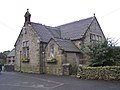 Onecote Church Hall - geograph.org.uk - 941279.jpg 640 × 480; 76 KB
-
 Onecote Grange, a farm - geograph.org.uk - 2515463.jpg 3,648 × 2,736; 5.66 MB
-
 Onecote Grange, Staffordshire - geograph.org.uk - 6308127.jpg 4,988 × 3,521; 3.2 MB
-
 Onecote Primitive Methodist Chapel - geograph.org.uk - 4182611.jpg 800 × 600; 127 KB
-
 Onecote, sheep grazing - geograph.org.uk - 4688528.jpg 1,024 × 768; 174 KB
-
 Oxbow lakes under construction - geograph.org.uk - 2515470.jpg 3,648 × 2,736; 5.98 MB
-
 Patterns in the fields - geograph.org.uk - 2515519.jpg 3,648 × 2,736; 4.19 MB
-
 Peak District Boundary, Millstone Marker - geograph.org.uk - 6548522.jpg 2,000 × 1,333; 2.26 MB
-
 Pethills Lane - geograph.org.uk - 2367828.jpg 640 × 480; 200 KB
-
 Pethillshead - geograph.org.uk - 2367837.jpg 640 × 480; 218 KB
-
 Pond under construction - geograph.org.uk - 4178603.jpg 4,000 × 2,248; 4.52 MB
-
 Ponies in field with small pond - geograph.org.uk - 2515481.jpg 2,518 × 1,824; 957 KB
-
 Rebuilding the wall on Douse Lane - geograph.org.uk - 3005442.jpg 1,142 × 857; 331 KB
-
 Rest home for trucks^ - geograph.org.uk - 4178609.jpg 4,000 × 2,248; 4.97 MB
-
 River Hamps above Onecote - geograph.org.uk - 470184.jpg 640 × 427; 132 KB
-
 River Hamps and Bridge, Onecote - geograph.org.uk - 6548092.jpg 2,000 × 1,333; 3.24 MB
-
 River Hamps at Ford Bridge - geograph.org.uk - 2367798.jpg 640 × 480; 236 KB
-
 River Hamps near White Lea Farm - geograph.org.uk - 3005429.jpg 1,142 × 857; 403 KB
-
 Road by the viewpoint - geograph.org.uk - 6128247.jpg 1,600 × 1,067; 296 KB
-
 Road near Cross Ways Farm - geograph.org.uk - 6128135.jpg 1,067 × 1,600; 372 KB
-
 Road to Winkhill - geograph.org.uk - 2367843.jpg 640 × 480; 246 KB
-
 Ruinous barn by Wetley Lane - geograph.org.uk - 6308555.jpg 4,803 × 3,600; 3.97 MB
-
 St Luke's Church, Onecote - geograph.org.uk - 4178595.jpg 4,000 × 2,248; 5.35 MB
-
 St. Luke's Church, Onecote - geograph.org.uk - 6548021.jpg 2,000 × 1,333; 2.11 MB
-
 Start of the lane to Elkstone - geograph.org.uk - 4023124.jpg 1,024 × 624; 92 KB
-
 Stile and sheep near Lumbs Farm - geograph.org.uk - 4023197.jpg 768 × 1,024; 168 KB
-
 Stream at Onecote - geograph.org.uk - 1738850.jpg 640 × 426; 88 KB
-
 The former Mermaid Inn - geograph.org.uk - 4889513.jpg 1,200 × 799; 400 KB
-
 The former Mermaid public house - geograph.org.uk - 4889365.jpg 1,200 × 799; 306 KB
-
 The Hamps valley near Dale House - geograph.org.uk - 3005424.jpg 857 × 1,142; 338 KB
-
 The Jervis Arms - geograph.org.uk - 4182616.jpg 800 × 600; 119 KB
-
 The Jervis Arms, Onecote - geograph.org.uk - 2515334.jpg 3,648 × 2,736; 5.79 MB
-
 The Mermaid Inn - geograph.org.uk - 4459435.jpg 4,320 × 3,240; 3.95 MB
-
 The Mermaid Inn - geograph.org.uk - 765284.jpg 640 × 426; 67 KB
-
 The Mermaid Inn, Onecote.jpg 845 × 476; 408 KB
-
 The old telephone kiosk in Ford - geograph.org.uk - 6308540.jpg 3,888 × 5,184; 6.46 MB
-
 The River Hamps near Ford - geograph.org.uk - 4182598.jpg 800 × 600; 261 KB
-
 The Stable at Harvey Gate - geograph.org.uk - 4749535.jpg 640 × 480; 103 KB
-
 The track to Mixon - geograph.org.uk - 6308133.jpg 4,977 × 3,492; 3.4 MB
-
 The upper Hamps valley - geograph.org.uk - 3005405.jpg 1,142 × 857; 346 KB
-
 These won't get through the MOT - geograph.org.uk - 2515493.jpg 3,648 × 2,736; 5.95 MB
-
 Three ewes observing photographer - geograph.org.uk - 2354171.jpg 3,648 × 2,736; 5.23 MB
-
 Triangle - geograph.org.uk - 5082160.jpg 5,184 × 2,577; 1.92 MB
-
 Triangulation pillar at Merryton Low - geograph.org.uk - 6324387.jpg 5,175 × 3,787; 5.8 MB
-
 Two tracks in Staffordshire hill farm country - geograph.org.uk - 2354173.jpg 3,648 × 2,736; 5.02 MB
-
 Upland pasture - geograph.org.uk - 2367825.jpg 640 × 480; 224 KB
-
 Uppert Acre Farm - geograph.org.uk - 4178624.jpg 4,000 × 2,248; 5.04 MB
-
 Valley of the River Hamps - geograph.org.uk - 4182619.jpg 800 × 600; 110 KB
-
 Vehicle storage at Mixon Mines - geograph.org.uk - 4182626.jpg 800 × 600; 152 KB
-
 View across the Hamps Valley from Mixon - geograph.org.uk - 6309435.jpg 4,910 × 3,754; 6.22 MB
-

-
 View at The Mermaid - geograph.org.uk - 2352995.jpg 3,648 × 2,736; 5.27 MB
-
 View from Merryton Low - geograph.org.uk - 6128373.jpg 1,600 × 1,067; 309 KB
-
 View from Morridge - geograph.org.uk - 6223827.jpg 1,600 × 1,067; 317 KB
-
 View from the cemetery in Onecote - geograph.org.uk - 593643.jpg 640 × 166; 77 KB
-
 View of Onecote - geograph.org.uk - 6223820.jpg 1,600 × 1,067; 275 KB
-
 View of Onecote Village - geograph.org.uk - 593666.jpg 640 × 480; 137 KB
-
 Village Hall, Onecote - geograph.org.uk - 2515342.jpg 3,648 × 2,736; 6.05 MB
-
 Waterhouse farm - geograph.org.uk - 3005440.jpg 979 × 734; 355 KB
-
 Well protected homestead - geograph.org.uk - 2515489.jpg 3,648 × 2,736; 6.29 MB
-
 Wetley Lane leading to Ford Wetley House - geograph.org.uk - 6308548.jpg 5,061 × 3,627; 6.93 MB
-
 White Lea Farm from above - geograph.org.uk - 3005397.jpg 1,142 × 857; 295 KB
-
 Wobbly stile and lots of nettles - geograph.org.uk - 2515338.jpg 3,648 × 2,736; 5.75 MB
-
 Young bull above The River Hamps - geograph.org.uk - 6308152.jpg 4,944 × 3,643; 3.77 MB
-
 Young cows at Banktop Farm, Ford - geograph.org.uk - 6309044.jpg 4,983 × 3,686; 3.67 MB
-
 Hay field on Moorside - Morridge - geograph.org.uk - 456697.jpg 640 × 427; 126 KB
-
 New Hall Farm - geograph.org.uk - 593622 (cropped).jpg 394 × 414; 71 KB
-
 New Hall Farm - geograph.org.uk - 593622.jpg 480 × 640; 144 KB
-
 Onecote Chapel - geograph.org.uk - 223837.jpg 640 × 480; 113 KB
-
 Onecote Telephone Exchange - geograph.org.uk - 223832.jpg 640 × 480; 147 KB
-
 Pethills Farm - geograph.org.uk - 423704.jpg 640 × 480; 91 KB
-
 Pipes on the front drive - geograph.org.uk - 456704.jpg 640 × 427; 99 KB
-
 The Jervis Arms - geograph.org.uk - 223841.jpg 640 × 640; 175 KB


,_Onecote_parish_-_geograph.org.uk_-_6049440.jpg)


.jpg)


