Category:Ponte romana sobre a Ribeira de Odivelas (Alentejo)
| Object location | | View all coordinates using: OpenStreetMap |
|---|
bridge in Portugal  | |||||
| Upload media | |||||
| Instance of | |||||
|---|---|---|---|---|---|
| Location | Lusitania, Hispania, Iberian Peninsula, Europe, Northern Hemisphere | ||||
| Heritage designation | |||||
| Inception |
| ||||
 | |||||
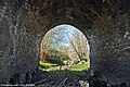
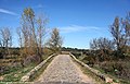
Português: Ponte Romana sobre a Ribeira de Odivelas / Ponte de Vila Ruiva. Portugal, Beja, Cuba, Vila Ruiva
|
This monument is classified as
Monumento Nacional .It is indexed in the IGESPAR database ( Instituto de Gestão do Património Arquitectónico e Arqueológico ), under the reference 69745.It is indexed in the SIPA database (Sistema de Informação para o Património Arquitectónico) under the reference 1027. |
Media in category "Ponte romana sobre a Ribeira de Odivelas (Alentejo)"
The following 16 files are in this category, out of 16 total.
-
 Pont romain ponte romana (400661858).jpg 1,000 × 379; 80 KB
-
 Ponte Romana de Vila Ruiva - Portugal (15967100320).jpg 3,790 × 2,526; 2.47 MB
-
 Ponte Romana de Vila Ruiva - Portugal (16154405115).jpg 2,592 × 3,888; 3.07 MB
-
 Ponte Romana de Vila Ruiva - Portugal (16390649468).jpg 3,888 × 2,592; 2.74 MB
-
 Ponte Romana de Vila Ruiva - Portugal (16392021289).jpg 3,828 × 2,533; 2.27 MB
-
 Ponte Romana de Vila Ruiva - Portugal (16395085904).jpg 3,888 × 2,489; 2.57 MB
-
 Ponte Romana de Vila Ruiva - Portugal (17493456921).jpg 3,858 × 2,572; 2.25 MB
-
 Ponte Romana de Vila Ruiva - Portugal (18269288303).jpg 3,888 × 2,592; 3.07 MB
-
 Ponte Romana de Vila Ruiva - Portugal (18702214078).jpg 2,592 × 3,888; 3.09 MB
-
 Ponte romana sobre a ribeira de Odivelas 01.png 640 × 480; 390 KB
-
 Ponte romana sobre a ribeira de Odivelas 02.png 640 × 480; 640 KB
-
 Ponte romana sobre a ribeira de Odivelas 03.png 640 × 480; 639 KB
-
 Roman Bridge, Ponte Romana de Vila Ruiva, Lusitania, Portugal (12749433215).jpg 4,928 × 3,264; 14.82 MB
-
 Roman Bridge, Ponte Romana de Vila Ruiva, Lusitania, Portugal (12749443805).jpg 4,928 × 3,264; 14.38 MB
-
 Roman Bridge, Ponte Romana de Vila Ruiva, Lusitania, Portugal (12749455515).jpg 4,928 × 3,264; 12.42 MB
-
 Roman Bridge, Ponte Romana de Vila Ruiva, Lusitania, Portugal (12749600173).jpg 4,928 × 3,264; 14.28 MB
.jpg)
.jpg)
.jpg)
.jpg)
.jpg)
.jpg)
.jpg)
.jpg)


.jpg)
.jpg)
.jpg)
.jpg)
.jpg)