Category:Preston Bagot
village in United Kingdom  | |||||
| Upload media | |||||
| Instance of | |||||
|---|---|---|---|---|---|
| Location | Stratford-on-Avon, Warwickshire, West Midlands, England | ||||
| Population |
| ||||
| Area |
| ||||
 | |||||
Subcategories
This category has the following 3 subcategories, out of 3 total.
P
- Preston Bagot Manor House (5 F)
T
- The Crabmill, Preston Bagot (5 F)
Media in category "Preston Bagot"
The following 200 files are in this category, out of 333 total.
(previous page) (next page)-
 'Weavers', Hazelwood Green - geograph.org.uk - 2701442.jpg 640 × 480; 161 KB
-
 A glimpse of Hazelwood Green Farm - geograph.org.uk - 6002182.jpg 1,024 × 768; 1.08 MB
-
 A pair of lambs - geograph.org.uk - 6141784.jpg 1,024 × 768; 305 KB
-
 A welcome rest, if a little low - geograph.org.uk - 3110597.jpg 480 × 640; 130 KB
-
 A4189 descending to the Crab Mill - geograph.org.uk - 2749575.jpg 640 × 427; 387 KB
-
 A4189 past Preston Bagot - geograph.org.uk - 2396233.jpg 1,280 × 960; 417 KB
-
 A4189 through Preston Green - geograph.org.uk - 2689263.jpg 640 × 480; 87 KB
-
 Access road to Preston Hill Farm - geograph.org.uk - 6141850.jpg 1,024 × 768; 240 KB
-
 Alders and willows by Kingswood Brook - geograph.org.uk - 2146412.jpg 640 × 427; 381 KB
-
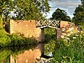
 Approaching Lock 36, Stratford-upon-Avon Canal - geograph.org.uk - 6234701.jpg 1,024 × 768; 343 KB
-
 Approaching Preston Bagot - geograph.org.uk - 5538197.jpg 3,129 × 2,126; 1.09 MB
-
 Barley by the Heart of England Way - geograph.org.uk - 5536599.jpg 2,711 × 2,010; 1,002 KB
-
 Barley near Hungerfield Farm - geograph.org.uk - 5536607.jpg 3,264 × 2,075; 1.48 MB
-
 Barley near Hungerfield Farm - geograph.org.uk - 5536615.jpg 3,025 × 1,878; 1.09 MB
-
 Barns, Preston Bagot Farm - geograph.org.uk - 2749623.jpg 640 × 480; 347 KB
-
 Bend in a farm drive - geograph.org.uk - 2745561.jpg 640 × 480; 460 KB
-
 Bluebells on a steep bank - geograph.org.uk - 2396261.jpg 1,280 × 960; 646 KB
-

-
 Bridge 47, Stratford Canal - geograph.org.uk - 4844235.jpg 1,280 × 851; 478 KB
-
 Bridge 47, Stratford-upon-Avon canal - geograph.org.uk - 2396358.jpg 1,280 × 960; 479 KB
-
 Bridge 47A from Bridge 48 - geograph.org.uk - 2396352.jpg 1,280 × 960; 420 KB
-
 Bridge 48 from Bridge 47A - geograph.org.uk - 2396339.jpg 1,280 × 960; 397 KB
-
 Bridge 49, Stratford-upon-Avon Canal - geograph.org.uk - 2849041.jpg 2,000 × 1,496; 527 KB
-
 Bridge 49, Stratford-upon-Avon Canal - geograph.org.uk - 6141825.jpg 1,024 × 768; 301 KB
-
 Bridge 49, Stratford-upon-Avon Canal - geograph.org.uk - 6141831.jpg 1,024 × 768; 315 KB
-
 Bridge 50, Stratford Canal - geograph.org.uk - 4315176.jpg 1,280 × 851; 360 KB
-
 Bridge 50, Stratford-upon-Avon canal - geograph.org.uk - 6141840.jpg 1,024 × 768; 386 KB
-
 Bridge and Lock near Preston Bagot, Warwickshire - geograph.org.uk - 3409030.jpg 1,024 × 716; 510 KB
-
 Bridge and lock near Preston Bagot, Warwickshire - geograph.org.uk - 3409286.jpg 1,024 × 726; 421 KB
-
 Bridge and lock near Preston Bagot, Warwickshire - geograph.org.uk - 3409295.jpg 1,024 × 696; 489 KB
-

-

-

-
 Bridge No 46 east of Preston Bagot, Warwickshire - geograph.org.uk - 3718364.jpg 768 × 1,024; 536 KB
-
 Bridge No 48 near Preston Bagot - geograph.org.uk - 5292171.jpg 800 × 750; 150 KB
-
 Bridge No 48 near Preston Bagot, Warwickshire - geograph.org.uk - 3410813.jpg 1,024 × 768; 482 KB
-
 Bridge No 48 near Preston Bagot, Warwickshire - geograph.org.uk - 3717689.jpg 768 × 1,024; 394 KB
-
 Bridge No 48 near Preston Bagot, Warwickshire - geograph.org.uk - 3717704.jpg 768 × 1,024; 429 KB
-

-

-

-
 Bridge No 49 south of Preston Bagot, Warwickshire - geograph.org.uk - 3717291.jpg 1,024 × 1,024; 638 KB
-

-
 Bridge No 50 near Wootton Wawen, Warwickshire - geograph.org.uk - 3412045.jpg 1,024 × 691; 463 KB
-

-

-
 Bridge over Canal - geograph.org.uk - 736247.jpg 640 × 480; 112 KB
-
 Bridge ^48, Stratford-Upon-Avon Canal - geograph.org.uk - 3548821.jpg 640 × 481; 335 KB
-

-
 Bridge^49, Stratford-Upon-Avon Canal - geograph.org.uk - 3548848.jpg 640 × 481; 404 KB
-
 Brook above Pettiford Bridge - geograph.org.uk - 2745571.jpg 640 × 480; 454 KB
-

-
 Brook valley below Rookery - geograph.org.uk - 2143979.jpg 640 × 427; 318 KB
-
 Brook west of Manor Farm - geograph.org.uk - 2396319.jpg 960 × 1,280; 640 KB
-

-

-
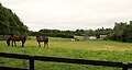
 Buttercups and black cattle - geograph.org.uk - 2396757.jpg 1,280 × 960; 310 KB
-
 By Hole Farm (geograph 5537510).jpg 2,417 × 1,297; 483 KB
-

-

-
 Canal-watching, Lock 37 - geograph.org.uk - 2379307.jpg 1,280 × 960; 536 KB
-
 Cattle grazing near Church Farm - geograph.org.uk - 2702521.jpg 640 × 427; 297 KB
-
 Cattle, Preston Fields - geograph.org.uk - 2143959.jpg 640 × 427; 340 KB
-
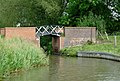
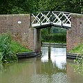
 Chequerboard bridge parapets, 1 - geograph.org.uk - 2379340.jpg 1,280 × 960; 489 KB
-
 Chequerboard bridge parapets, 2 - geograph.org.uk - 2379363.jpg 1,280 × 960; 321 KB
-
 Chequerboard bridge parapets, 3 - geograph.org.uk - 2379390.jpg 1,280 × 960; 341 KB
-
 Church Farmhouse - geograph.org.uk - 6141791.jpg 1,024 × 768; 362 KB
-
 Church Farmhouse, Preston Bagot - geograph.org.uk - 2379205.jpg 1,280 × 960; 387 KB
-
 Churchyard, All Saints', Preston Bagot - geograph.org.uk - 5537754.jpg 3,264 × 2,448; 1.89 MB
-
 Churchyard, All Saints', Preston Bagot - geograph.org.uk - 5537760.jpg 3,264 × 2,448; 2.16 MB
-
 Claverdon Rugby Club - geograph.org.uk - 2401875.jpg 800 × 533; 99 KB
-

-

-
 Country road at Preston Bagot - geograph.org.uk - 6141801.jpg 1,024 × 768; 353 KB
-

-
 Crimson keys of field maple - geograph.org.uk - 2749553.jpg 640 × 480; 418 KB
-
 Crop emerging near Preston Hill Farm - geograph.org.uk - 2749138.jpg 640 × 480; 464 KB
-
 Cultivated field by Henley Road - geograph.org.uk - 2702953.jpg 640 × 480; 358 KB
-
 Cultivated field west of Kington Grange - geograph.org.uk - 2749055.jpg 640 × 427; 429 KB
-
 Cycling along the A4189 Warwick Road - geograph.org.uk - 4722579.jpg 800 × 701; 174 KB
-
 Damaged Weir - geograph.org.uk - 2659783.jpg 480 × 640; 148 KB
-
 Decaying tree by the canal - geograph.org.uk - 2849135.jpg 2,000 × 1,503; 487 KB
-
 Dip in Preston Field Lane - geograph.org.uk - 2143975.jpg 640 × 480; 607 KB
-
 Disintegrating carcase of a tree - geograph.org.uk - 2745537.jpg 640 × 480; 419 KB
-
 Dismantled bridge over Kingswood Brook - geograph.org.uk - 2978616.jpg 2,000 × 1,500; 430 KB
-
 Drive to Hole Farm, Preston Green - geograph.org.uk - 2689244.jpg 640 × 480; 87 KB
-
 Drive to Oak Cottage and Canal Cottage - geograph.org.uk - 2742783.jpg 640 × 480; 357 KB
-
 Edge Lane - geograph.org.uk - 6143358.jpg 1,024 × 768; 239 KB
-
 Erosion by cattle, Preston Fields - geograph.org.uk - 2143950.jpg 640 × 480; 566 KB
-
 Farm Track - geograph.org.uk - 2656990.jpg 640 × 480; 80 KB
-
 Farmland at Preston Bagot - geograph.org.uk - 4844167.jpg 1,280 × 851; 433 KB
-
 Farmland at Preston Bagot - geograph.org.uk - 4844196.jpg 1,280 × 851; 382 KB
-

-

-
 Field above the Tapster Brook - geograph.org.uk - 2396744.jpg 1,280 × 960; 276 KB
-
 Field at Kite Green - geograph.org.uk - 6143369.jpg 1,024 × 768; 243 KB
-
 Field below house at Kite Green - geograph.org.uk - 2701838.jpg 640 × 480; 110 KB
-
 Field by Ossetts Hole Lane - geograph.org.uk - 2401814.jpg 800 × 533; 119 KB
-
 Field edge southwest of Holly Bank Farm - geograph.org.uk - 2702400.jpg 640 × 480; 397 KB
-
 Field near Kite Green - geograph.org.uk - 5537684.jpg 3,226 × 1,780; 1.35 MB
-
 Field, Preston Bagot - geograph.org.uk - 5538008.jpg 3,250 × 2,049; 1.63 MB
-
 Field, Preston Bagot - geograph.org.uk - 5538155.jpg 3,250 × 2,270; 1.94 MB
-
 Fields north of Hazelwood Green - geograph.org.uk - 2701192.jpg 640 × 480; 93 KB
-
 Fields north of Stratford-upon-Avon Canal - geograph.org.uk - 2849100.jpg 2,000 × 1,333; 529 KB
-
 Flood gauge, Rookery Lane ford - geograph.org.uk - 2143956.jpg 512 × 640; 603 KB
-
 Flood-prone stretch of Henley Road - geograph.org.uk - 2703358.jpg 640 × 480; 447 KB
-

-
 Footbridge over Kingswood Brook - geograph.org.uk - 2978628.jpg 1,500 × 1,988; 432 KB
-
 Footbridge over Tapster Brook - geograph.org.uk - 2146433.jpg 640 × 427; 428 KB
-
 Footbridge over the Preston Bagot Brook - geograph.org.uk - 3090468.jpg 640 × 480; 132 KB
-
 Footpath to Ossetts Hole Lane - geograph.org.uk - 2978570.jpg 1,500 × 2,002; 588 KB
-

-
 Ford on Preston Field Lane, 1 - geograph.org.uk - 2145244.jpg 640 × 480; 526 KB
-
 Ford on Preston Field Lane, 2 - geograph.org.uk - 2145247.jpg 640 × 480; 555 KB
-
 Ford on Preston Fields Lane - geograph.org.uk - 2980377.jpg 3,872 × 2,592; 2.42 MB
-
 Ford on Rookery Lane, Preston Fields - geograph.org.uk - 2980372.jpg 2,592 × 3,872; 2.32 MB
-
 Former lock-keeper's cottage, Lock 37 - geograph.org.uk - 2396130.jpg 1,280 × 960; 451 KB
-

-
 Gable ends, Preston Bagot Farm - geograph.org.uk - 2396111.jpg 1,280 × 960; 396 KB
-
 Game crop by a plantation - geograph.org.uk - 2749119.jpg 640 × 480; 558 KB
-
 Gate fastening, Preston Bagot - geograph.org.uk - 5538034.jpg 2,600 × 1,991; 1.46 MB
-
 Grass field near Hole Farm - geograph.org.uk - 5537523.jpg 3,264 × 2,448; 2.33 MB
-
 Green Lane Bridge - geograph.org.uk - 3450859.jpg 3,776 × 2,520; 4.03 MB
-
 Green Lane Bridge No 51 - geograph.org.uk - 4723480.jpg 800 × 600; 218 KB
-

-
-

-
 Heart of England Way - geograph.org.uk - 5536497.jpg 3,245 × 1,986; 1.32 MB
-
 Heart of England Way crossing a pasture - geograph.org.uk - 2702377.jpg 640 × 427; 340 KB
-
 Heart of England Way from Edge Lane - geograph.org.uk - 5536634.jpg 3,250 × 1,977; 1.29 MB
-
 Heart of England Way near Holly Bank Farm - geograph.org.uk - 5536467.jpg 3,264 × 2,164; 1.82 MB
-

-
 Heart of England Way near Hungerfield Farm - geograph.org.uk - 5536483.jpg 2,448 × 3,264; 2.93 MB
-
 Heart of England Way near Hungerfield Farm - geograph.org.uk - 5536493.jpg 3,264 × 2,448; 1.66 MB
-
 Heart of England Way west of Holly Bank Farm - geograph.org.uk - 5536580.jpg 3,264 × 2,116; 1.91 MB
-
 Henley Rd, Lowsonford - geograph.org.uk - 3106694.jpg 640 × 480; 69 KB
-
 Henley Road bridges Tapster Brook, 1 - geograph.org.uk - 2703329.jpg 640 × 480; 514 KB
-
 Henley Road bridges Tapster Brook, 2 - geograph.org.uk - 2703343.jpg 640 × 480; 474 KB
-
 Hillside north of Rookery - geograph.org.uk - 2146469.jpg 640 × 480; 322 KB
-
 Holly Bank Farm - geograph.org.uk - 2145220.jpg 640 × 427; 296 KB
-
 Holly Bank Farm - geograph.org.uk - 3106589.jpg 640 × 480; 50 KB
-
 Horsebox in a field-corner - geograph.org.uk - 2396149.jpg 1,280 × 853; 352 KB
-
 House at Preston Fields. - geograph.org.uk - 3106457.jpg 640 × 480; 97 KB
-
 In Bucket Lock near Preston Bagot, Warwickshire - geograph.org.uk - 3408185.jpg 1,024 × 768; 567 KB
-

-

-
 Kings Norton 16 miles - geograph.org.uk - 2978505.jpg 2,000 × 1,490; 377 KB
-
 Kingswood Brook - geograph.org.uk - 5538053.jpg 2,448 × 3,264; 2.21 MB
-
 Kingswood Brook - geograph.org.uk - 5538081.jpg 2,448 × 3,264; 2.44 MB
-
 Kissing gate - geograph.org.uk - 6141785.jpg 1,024 × 768; 310 KB
-
 Knoll south of Preston Bagot - geograph.org.uk - 2396330.jpg 1,280 × 768; 321 KB
-
 Lane junction in shadow, Hazelwood Green - geograph.org.uk - 6179635.jpg 1,024 × 768; 327 KB
-
 Lane junction, Hazelwood Green - geograph.org.uk - 2701405.jpg 640 × 480; 156 KB
-
 Lane next to Canal Cottage - geograph.org.uk - 4723477.jpg 800 × 624; 201 KB
-
 Lane, Preston Bagot - geograph.org.uk - 5537828.jpg 3,264 × 2,448; 2.12 MB
-
 Lane, Preston Bagot - geograph.org.uk - 5537947.jpg 2,448 × 3,264; 2.13 MB
-
 Lilac Cottage, Preston Field Lane - geograph.org.uk - 2143963.jpg 640 × 480; 372 KB
-
 Lock 36, Stratford-upon-Avon Canal (geograph 5538246).jpg 3,081 × 2,149; 1.08 MB
-
 Lock 36, Stratford-upon-Avon Canal - geograph.org.uk - 2978536.jpg 2,000 × 1,492; 348 KB
-

-
 Lock 38 Sign - geograph.org.uk - 741674.jpg 640 × 480; 133 KB
-
 Lock and Bridge near Preston Bagot, Warwickshire - geograph.org.uk - 3409033.jpg 1,024 × 768; 494 KB
-

-

-
 Lock cottage Preston Bagot - geograph.org.uk - 483914.jpg 640 × 435; 68 KB
-
 Lock No 35 near Preston Bagot, Warwickshire - geograph.org.uk - 3409277.jpg 1,024 × 768; 502 KB
-
 Lock No 37 near Preston Bagot, Warwickshire - geograph.org.uk - 3410647.jpg 1,024 × 751; 473 KB
-
 Lock No 38 near Preston Bagot, Warwickshire - geograph.org.uk - 3410789.jpg 1,024 × 712; 490 KB
-
 Meadow and woodland, Preston Bagot - geograph.org.uk - 2396275.jpg 1,280 × 960; 510 KB
-
 Meander on Tapster Brook, Preston Fields - geograph.org.uk - 6179305.jpg 1,024 × 768; 504 KB
-
 Mixed herd near Preston Green - geograph.org.uk - 2687041.jpg 640 × 480; 74 KB
-
 Moat and earthworks - geograph.org.uk - 6141846.jpg 1,024 × 768; 217 KB
-

-
 Narrow lane overhung by trees - geograph.org.uk - 2701807.jpg 640 × 480; 152 KB
-

-
 Narrowboat on the Stratford Canal - geograph.org.uk - 5538259.jpg 3,264 × 2,448; 3.06 MB
-
 Narrowboat, Stratford-Upon-Avon Canal - geograph.org.uk - 3548839.jpg 640 × 481; 307 KB
-
 Narrowboats near Preston Bagot, Warwickshire - geograph.org.uk - 3718837.jpg 1,024 × 740; 524 KB
-

-
 Near Church Farm, Preston Bagot - geograph.org.uk - 5538172.jpg 2,908 × 1,499; 1.18 MB
-
 Negotiating Lock 37 - geograph.org.uk - 2379286.jpg 1,280 × 960; 360 KB
-

-
 No doubt where to go - geograph.org.uk - 3110560.jpg 640 × 480; 99 KB
-
 Oak coppice near Hungerfield Farm - geograph.org.uk - 2702372.jpg 640 × 480; 527 KB
-
 Oak trees in a hedgerow - geograph.org.uk - 6143344.jpg 1,024 × 768; 298 KB
-
 Oats at Hungerfield Farm - geograph.org.uk - 5536620.jpg 3,264 × 2,448; 1.83 MB
-
 Old signpost at Preston Bagot - geograph.org.uk - 3109963.jpg 640 × 480; 199 KB
-
 Ossetts Hole Lane - geograph.org.uk - 2401781.jpg 800 × 600; 132 KB
-
 Overflow on the Stratford Canal - geograph.org.uk - 2748948.jpg 480 × 640; 493 KB
-
 Packing up the kite - geograph.org.uk - 2396772.jpg 1,280 × 853; 355 KB
-
 Paddock near Hole Farm - geograph.org.uk - 2688412.jpg 640 × 480; 53 KB
-
 Paddock, Preston Bagot Farm - geograph.org.uk - 2749511.jpg 640 × 427; 397 KB
-
 Paddocks north of Hole Farm - geograph.org.uk - 2688478.jpg 640 × 476; 65 KB
-
 Parsonfield, Edge Lane - geograph.org.uk - 2702334.jpg 640 × 427; 308 KB
-
 Pasture at Hazelwood Green - geograph.org.uk - 2701473.jpg 640 × 480; 85 KB
-
 Pasture south of Preston Bagot, Warwickshire - geograph.org.uk - 3717648.jpg 1,024 × 700; 341 KB
-
 Pasture south of Preston Bagot, Warwickshire - geograph.org.uk - 3717650.jpg 1,024 × 696; 294 KB
-
 Pasture south of Preston Bagot, Warwickshire - geograph.org.uk - 3717653.jpg 1,024 × 706; 325 KB
-

-


.jpg)


.jpg)


