Category:Raadhuis (Kortenhoef)
| Object location | | View all coordinates using: OpenStreetMap |
|---|
 | |||||
| Upload media | |||||
| Instance of | |||||
|---|---|---|---|---|---|
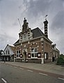
| Location | Kortenhoef, North Holland, Netherlands | ||||
| Street address |
| ||||
| Located on street |
| ||||
| Heritage designation |
| ||||
 | |||||
Nederlands: Voormalig raadhuis
|
This is a category about rijksmonument number 520857
|
| Address |
|
Media in category "Raadhuis (Kortenhoef)"
The following 3 files are in this category, out of 3 total.
-
 Kortenhoef RM Kortenhoefsedijk 155.jpg 3,480 × 3,457; 5.18 MB
-
 Kortenhoefsedijk 155.png 943 × 1,417; 2.42 MB
-