Category:Royal Herbert Hospital
| Object location | | View all coordinates using: OpenStreetMap |
|---|
former hospital  | |||||
| Upload media | |||||
| Instance of | |||||
|---|---|---|---|---|---|
| Named after | |||||
| Location | Shooter's Hill, Royal Borough of Greenwich, Greater London, London, England | ||||
| Inception |
| ||||
| Date of official closure |
| ||||
 | |||||
Media in category "Royal Herbert Hospital"
The following 29 files are in this category, out of 29 total.
-
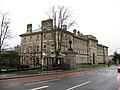 Former Royal Herbert Hospital, Woolwich - geograph.org.uk - 2286932.jpg 1,024 × 768; 327 KB
-
 London, SE18 - Former Royal Herbert Hospital - geograph.org.uk - 3183886.jpg 3,196 × 2,780; 1.71 MB
-
 London, SE18 - Former Royal Herbert Hospital - geograph.org.uk - 3183905.jpg 2,779 × 3,877; 2.06 MB
-
 London, SE18 - Former Royal Herbert Hospital - geograph.org.uk - 3183928.jpg 3,001 × 3,464; 1.99 MB
-
 London, SE18 - Former Royal Herbert Hospital - geograph.org.uk - 3183983.jpg 3,970 × 2,800; 2.49 MB
-
 London, Shooters Hill, Herbert Hospital 01.jpg 2,400 × 1,412; 1.34 MB
-
 London, Shooters Hill, Herbert Hospital 02.jpg 2,400 × 1,761; 1.13 MB
-
 London, Shooters Hill, Herbert Hospital 03.jpg 2,400 × 1,906; 1.33 MB
-
 London, Shooters Hill, Herbert Hospital 04.jpg 1,801 × 2,400; 1.12 MB
-
 London, Shooters Hill, Herbert Hospital 05.jpg 2,400 × 1,800; 1.49 MB
-
 London, Shooters Hill, Herbert Hospital 06.jpg 2,400 × 1,800; 1.33 MB
-
 London, Shooters Hill, Herbert Hospital 07.jpg 2,400 × 1,800; 1.56 MB
-
 London, Shooters Hill, Herbert Hospital 08.jpg 2,400 × 1,565; 1.41 MB
-
 London, Shooters Hill, Herbert Hospital 09.jpg 2,400 × 1,368; 1.33 MB
-
 London, Shooters Hill, Herbert Hospital 10.jpg 2,400 × 1,407; 1.43 MB
-
 London, Shooters Hill, Herbert Hospital 11.jpg 2,400 × 1,435; 1.25 MB
-
 Photograph; Royal Herbet Hospital Woowich Ward. Wellcome L0028759.jpg 1,771 × 1,188; 1.05 MB
-
 Postcard, the Royal Herbert Hospital, Major M. Holt. Wellcome L0024931.jpg 1,772 × 1,101; 635 KB
-
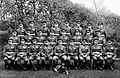 RAMC, Royal Herbert Hospital, Woolwich, 1928 Wellcome L0024926.jpg 1,774 × 1,151; 943 KB
-
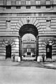 Royal Herbert Hospital Woolwich Entrance Gate. Wellcome L0028758.jpg 1,192 × 1,784; 1 MB
-
 Royal Herbert Hospital, Woolwich Wellcome L0050102.jpg 6,067 × 3,879; 3.53 MB
-
 Royal Herbert Hospital, Woolwich Wellcome L0050103.jpg 5,528 × 3,353; 3.7 MB
-
-
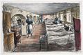
 Royal Herbert Hospital, Woolwich- Basement Ward Art.IWMARTLD1547.jpg 800 × 577; 88 KB
-
 Royal Herbert Hospital, Woolwich- the Sister Art.IWMARTLD1545.jpg 800 × 708; 94 KB
-
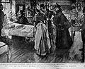 Royal Herbert Hospital, Woolwich; visit of Queen Victoria Wellcome L0024165.jpg 1,508 × 1,234; 656 KB
-
 The Herbert Military Hospital, Woolwich; the silhouette of t Wellcome V0013880.jpg 3,330 × 2,119; 3.14 MB
-
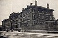 Woolwich, Herbert Hospital.jpg 1,624 × 1,054; 597 KB
-
 Woolwich; Herbert Hospital. Wellcome L0004207.jpg 1,636 × 1,120; 1,016 KB


