Category:Shooter's Hill
district in South East London, United Kingdom  | |||||
| Upload media | |||||
| Instance of | |||||
|---|---|---|---|---|---|
| Location | Royal Borough of Greenwich, Greater London, London, England | ||||
| Population |
| ||||
| Elevation above sea level |
| ||||
 | |||||
Main Wikipedia article: Shooter's Hill.
Subcategories
This category has the following 16 subcategories, out of 16 total.
A
B
- Brent Road, Woolwich (7 F)
E
- Eglinton Hill, Woolwich (16 F)
F
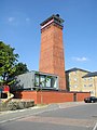
- Fire Station, Shooter's Hill (4 F)
H
O
P
R
- Royal Herbert Hospital (29 F)
S
- Shooter's Hill Water Tower (19 F)
- Shrewsbury Park, Woolwich (54 F)
V
Media in category "Shooter's Hill"
The following 41 files are in this category, out of 41 total.
-
 2015 London, Woolwich Common 19.jpg 2,400 × 1,029; 793 KB
-
 2015 London, Woolwich Common 22.jpg 2,400 × 960; 855 KB
-
 2015 London-Woolwich, aereal view.jpg 1,528 × 702; 395 KB
-
 2018 Thamesmead West, view from Gallions Hill 04.jpg 635 × 476; 114 KB
-
 2019 London, Shooter's Hill.jpg 2,574 × 1,117; 720 KB
-
 2019 View from Gallions Hill, SE London 01.jpg 4,320 × 3,240; 3.25 MB
-

-
 A Creekmouth Jetty - geograph.org.uk - 50921.jpg 640 × 482; 64 KB
-
 Ashridge Crescent, London SE18 - geograph.org.uk - 1589045.jpg 640 × 480; 89 KB
-
 Bushmoor Crescent, London SE18 - geograph.org.uk - 1589051.jpg 640 × 480; 56 KB
-
-
 Hanson "59".JPG 3,872 × 2,592; 2.93 MB
-
 Houses on Eaglesfield Road, SE18 - geograph.org.uk - 2608947.jpg 640 × 480; 92 KB
-
 Kinlet Road, London SE18 - geograph.org.uk - 1589039.jpg 640 × 480; 63 KB
-
 London MMB «Z9 Emirates Airline.jpg 4,004 × 2,552; 3.55 MB
-
 London MMB »000 Emirates Airline.jpg 4,105 × 2,133; 3.44 MB
-
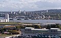
 London, George V Dock-North Woolwich-Woolwich-Shooters Hill, aerial view 02.jpg 2,728 × 1,348; 682 KB
-
 London, North Woolwich-George V Dock-Woolwich-Shooters Hill, aerial view 01.jpg 3,124 × 1,646; 970 KB
-
 London, North Woolwich-Thamesmead West-Woolwich-Shooters Hill, aerial view 01.jpg 3,136 × 2,013; 1.27 MB
-
 London, Shooter's Hill (GHC).jpg 2,400 × 1,518; 1.06 MB
-
 London, Silvertown-Woolwich, aerial view.JPG 1,706 × 1,136; 921 KB
-
 London, Thamesmead West-Woolwich-Shooters Hill, aerial view 01.jpg 3,262 × 944; 858 KB
-
 London, Thamesmead West-Woolwich-Shooters Hill, aerial view 02.jpg 2,993 × 1,141; 794 KB
-
 London, view of the Thames, Woolwich and Shooter's Hill.jpg 2,726 × 1,504; 1,007 KB
-
 London, Woolwich-Shooter's Hill, Foxcroft Road01.jpg 2,400 × 1,390; 1.2 MB
-
 London, Woolwich-Shooter's Hill, Occupation Lane01.jpg 2,400 × 1,800; 1.1 MB
-
 London, Woolwich-Shooter's Hill, Occupation Lane02.jpg 2,400 × 1,800; 1.15 MB
-
 London, Woolwich-Shooter's Hill, Occupation Lane03.jpg 2,400 × 1,613; 1.51 MB
-

-
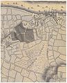 Map of Woolwich, 1740s.jpg 1,918 × 2,372; 4 MB
-
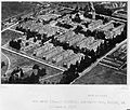
 North Eastern Hospital and Brook Hospital Wellcome L0001713.jpg 1,222 × 1,526; 765 KB
-
 Old Dover Road, Shooters Hill - geograph.org.uk - 3007772.jpg 640 × 480; 115 KB
-
 Oxleas Wood bus stops - geograph.org.uk - 2848809.jpg 640 × 480; 122 KB
-
 Prospect Cottage and the War Memorial at Shooter's Hill.jpg 4,592 × 3,448; 16.93 MB
-
 Prospect Cottage in Shooter's Hill.jpg 3,187 × 4,182; 11.49 MB
-
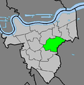 Shooter's Hill location.PNG 642 × 646; 25 KB
-
 The Brook (Fever) Hospital at Shooters Hill. Wellcome L0006810EA.jpg 1,536 × 1,300; 731 KB
-
 Victoria House, Shooters Hill, London SE18.jpg 3,216 × 2,758; 1.95 MB
-
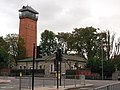 Water Tower on Shooter's Hill - geograph.org.uk - 2601423.jpg 4,288 × 3,216; 6.69 MB
-
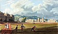 Woolwich, RMA, R W Lucas 1821 LMA.jpg 1,744 × 1,034; 564 KB
-
 Ypres Memorial Milestone, Shooter's Hill.jpg 3,464 × 2,517; 1.97 MB


.jpg)


.jpg)


_Hospital_at_Shooters_Hill._Wellcome_L0006810EA.jpg)


