Category:SVG linguistic maps of Oceania
Temperate regions: North America · South America · Africa · Europe · Asia · Oceania – Polar regions: – Other regions:
| NO WIKIDATA ID FOUND! Search for SVG linguistic maps of Oceania on Wikidata | |
| Upload media |

Countries of Oceania: Australia · Fiji · the Federated States of Micronesia ≈ Federated States of Micronesia · Kiribati · the Marshall Islands ≈ Marshall Islands · Nauru · New Zealand · Palau · Papua New Guinea · Samoa · the Solomon Islands ≈ Solomon Islands · Tonga · Tuvalu · Vanuatu
Other areas: American Samoa · Clipperton Island · the Cocos (Keeling) Islands ≈ Cocos (Keeling) Islands · the Cook Islands ≈ Cook Islands · French Polynesia · Guam · Hawaii · New Caledonia · Niue · Norfolk Island · the Northern Mariana Islands ≈ Northern Mariana Islands · the Pitcairn Islands ≈ Pitcairn Islands · Tokelau · Wallis and Futuna – Partly: the British Overseas Territories ≈ British Overseas Territories · Overseas France · Indonesia · the French Southern and Antarctic Lands ≈ French Southern and Antarctic Lands · the United States Minor Outlying Islands ≈ United States Minor Outlying Islands
Other areas: American Samoa · Clipperton Island · the Cocos (Keeling) Islands ≈ Cocos (Keeling) Islands · the Cook Islands ≈ Cook Islands · French Polynesia · Guam · Hawaii · New Caledonia · Niue · Norfolk Island · the Northern Mariana Islands ≈ Northern Mariana Islands · the Pitcairn Islands ≈ Pitcairn Islands · Tokelau · Wallis and Futuna – Partly: the British Overseas Territories ≈ British Overseas Territories · Overseas France · Indonesia · the French Southern and Antarctic Lands ≈ French Southern and Antarctic Lands · the United States Minor Outlying Islands ≈ United States Minor Outlying Islands
Media in category "SVG linguistic maps of Oceania"
The following 14 files are in this category, out of 14 total.
-
 Area of Papuan languages.svg 1,000 × 500; 731 KB
-
 Cook Islands languages map.svg 775 × 814; 167 KB
-
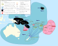
 Differenciation of Proto-Polynesian map -fr.svg 1,429 × 846; 106 KB
-
 Languages of Micronesia.en.svg 1,630 × 1,203; 4.66 MB
-
 Langues océaniennes.svg 738 × 527; 254 KB
-
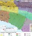
 Lorentz National Park Peoples map-fr.svg 1,943 × 2,198; 1.67 MB
-
 Lorentz National Park Peoples map-id.svg 1,943 × 2,197; 1.46 MB
-
 Lorentz National Park Peoples map-mk.svg 1,943 × 2,198; 1.63 MB
-
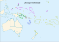
 Oceanic languages mk.svg 738 × 527; 262 KB
-
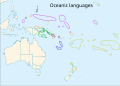 Oceanic languages.svg 738 × 527; 248 KB
-
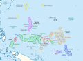
 Sociolinguistic Map of Polynesian Languages in the 21st Century - fr v2.svg 1,246 × 987; 3.89 MB
-
 Sociolinguistic map of Polynesian Languages in the 21st century - fr.svg 1,246 × 987; 3.75 MB
-

-
 Језици Океаније.svg 738 × 527; 245 KB


_multilingue.svg)
