Category:Schul- und Bethaus Wilhelmsdorf
| Object location | | View all coordinates using: OpenStreetMap |
|---|
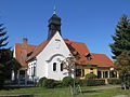
church building in Brandenburg an der Havel, Brandenburg state, Germany  | |||||
| Upload media | |||||
| Instance of | |||||
|---|---|---|---|---|---|
| Location | Wilhelmsdorf (Brandenburg), Brandenburg an der Havel, Brandenburg, Germany | ||||
| Street address |
| ||||
| Heritage designation | |||||
| Inception |
| ||||
 | |||||
This is the category of the Brandenburger Baudenkmal (cultural heritage monument) with the ID 09145611 (Wikidata)
|
Media in category "Schul- und Bethaus Wilhelmsdorf"
The following 4 files are in this category, out of 4 total.
-
 Bet- und schulhaus wilhelmsdorf rück.JPG 2,816 × 2,112; 2.22 MB
-
 Brandenburg (Havel), Schul- und Bethaus Wilhelmsdorf (1).jpg 4,598 × 2,652; 2.76 MB
-
 Brandenburg (Havel), Schul- und Bethaus Wilhelmsdorf (2).jpg 3,464 × 2,878; 2.06 MB
-
 Kirche wilhelmsdorf brb.JPG 2,816 × 2,112; 1.49 MB

,_Schul-_und_Bethaus_Wilhelmsdorf_(1).jpg)
,_Schul-_und_Bethaus_Wilhelmsdorf_(2).jpg)