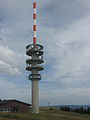
Category:Sender Feldberg (Black Forest, 2003)
_in_autum_2015.jpg) |
Feldberg by year · Feldberg by season (spring · summer · autumn · winter) · Feldberg by setting (Blue sky · Clouds · Fog · Snow · Sunrise · Sunset) · Aerial photographs · Alpine path · Animals · Art · Black and white photographs · Climate diagrams · Feldseekessel with Feldsee · Flora · Gallery page · Grüble · Panoramics · Information boards · Nature reserve · Quality images · Rock formations · Summit (see also Baldenweger Buck and Seebuck) · Views from · Views of (Historic views · Remote views, by compass direction from north, east, south, west) · Visitors · Zastler Loch · Buildings on Feldberg: Baldenweger Hut · Church · Feldberg aerial lift · Feldberger Hof · Haus of Nature · Mountain weather station · Saint Wilhelm Hut · Todtnauer Hut · Transmitter · Weather radar · Zastler Hut · |
| Object location | | View all coordinates using: OpenStreetMap |
|---|
 | |||||
| Upload media | |||||
| Instance of | |||||
|---|---|---|---|---|---|
| Location | Feldberg, Breisgau-Hochschwarzwald, Freiburg Government Region, Baden-Württemberg, Germany | ||||
| Commissioned by | |||||
 | |||||
Media in category "Sender Feldberg (Black Forest, 2003)"
The following 18 files are in this category, out of 18 total.
-
 2002-04-01 Sender Feldberg IMG 0357.jpg 2,109 × 1,582; 654 KB
-
 2012 Schwarzwald 101 Feldberg Gipfel.JPG 3,264 × 2,448; 2.31 MB
-
 Emetteur du Feldberg.jpg 907 × 1,107; 40 KB
-
 Feldberg (Schwarzwald) Radarstation und Feldbergturm (cropped).JPG 1,415 × 1,059; 254 KB
-
 Feldberg (Schwarzwald) Radarstation und Feldbergturm.JPG 2,304 × 1,704; 724 KB
-
 Feldberg 3981.jpg 2,048 × 1,536; 1.16 MB
-
 Feldberg Fernsehturm 3959.jpg 2,048 × 1,536; 1.03 MB
-
 Feldberg neien Tuerm.jpg 951 × 1,752; 404 KB
-
 Feldberg neuer turm oben.jpg 1,085 × 1,810; 240 KB
-
 Feldberg neuer Turm.jpg 951 × 1,752; 485 KB
-
 Feldbergturm und Wetterwarte am Feldberg im Schwarzwald.jpg 3,456 × 2,304; 2.59 MB
-
 Feldbergturm.jpg 3,456 × 2,304; 1.99 MB
-
 Kameramast Feldberg 12072015.JPG 2,676 × 3,568; 6.4 MB
-
 Landappbw 773176 1823 Funkturm Funkturm Feldberg.jpg 1,079 × 1,919; 216 KB
-
 Neuer Fernsehturm Feldberg 12072015 1.JPG 2,676 × 3,568; 6 MB
-
 Neuer Fernsehturm Feldberg 12072015 2.JPG 2,643 × 3,524; 5.89 MB
-
 Sendemast wetterrdar feldberg.jpg 1,099 × 542; 43 KB
-
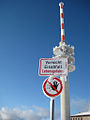 Sendeturm auf Feldberg - Eisabfall-Schild.jpg 768 × 1,024; 290 KB


_Radarstation_und_Feldbergturm_(cropped).JPG)
_Radarstation_und_Feldbergturm.JPG)


