Category:Shere
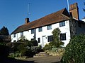
English: Shere is a village in the Guildford district of Surrey, England. It is about east of Guildford, on the A25. It is a small and attractive village in the traditional English sense. It has a small central cluster of old village houses, shops (including a blacksmiths), tea house, art gallery , two pubs and a church. The Tillingbourne, a small stream, runs through the centre of the village. Its attractiveness makes it popular with tourists from London and surrounding areas. It can be busy on weekends and bank holidays.

village and civil parish in Surrey, England  | |||||
| Upload media | |||||
| Instance of | |||||
|---|---|---|---|---|---|
| Location | Guildford, Surrey, South East England, England | ||||
| Area |
| ||||
 | |||||
Subcategories
This category has the following 10 subcategories, out of 10 total.
Media in category "Shere"
The following 200 files are in this category, out of 984 total.
(previous page) (next page)-
 "Elderly man at fence - A summer afternoon in Surrey" - Upper Street, Shere, Surrey.jpg 2,000 × 2,045; 2.1 MB
-
 'Flying Scotsman' - geograph.org.uk - 5421023.jpg 2,980 × 1,986; 7.58 MB
-
 3 Percy Villas - geograph.org.uk - 527119.jpg 640 × 480; 69 KB
-
 A cairn or just a pile of stones^ - geograph.org.uk - 2886709.jpg 1,024 × 768; 268 KB
-
 A corner of the churchyard, Shere - geograph.org.uk - 4497281.jpg 826 × 1,024; 207 KB
-
 A dense network of roots - geograph.org.uk - 3195507.jpg 640 × 430; 96 KB
-
 A shallow valley near Knowle Farm - geograph.org.uk - 2086969.jpg 640 × 430; 130 KB
-
 A shed or a barn^ Lawbrook Lane - geograph.org.uk - 2087204.jpg 640 × 430; 135 KB
-

-
 A25 - geograph.org.uk - 3376102.jpg 480 × 640; 70 KB
-
 A25 looking east - geograph.org.uk - 3271498.jpg 640 × 426; 56 KB
-
 A25 near Shere - geograph.org.uk - 5950179.jpg 2,953 × 1,345; 488 KB
-
 A25, looking west - geograph.org.uk - 3271503.jpg 640 × 426; 72 KB
-
 Abinger Telephone Exchange, Surrey - geograph.org.uk - 1952832.jpg 3,072 × 2,304; 1.78 MB
-
 Access road for houses off Hound House Road - geograph.org.uk - 4167223.jpg 2,560 × 1,920; 1.98 MB
-
 Allotments, Shere - geograph.org.uk - 3184958.jpg 640 × 430; 90 KB
-
 Allotments, Shere - geograph.org.uk - 3286359.jpg 640 × 426; 92 KB
-
 An arboreal oddity, Hurstwood - geograph.org.uk - 2091963.jpg 640 × 430; 199 KB
-
 An empty A25 - geograph.org.uk - 2599436.jpg 640 × 428; 66 KB
-
 Anchor Cottage - geograph.org.uk - 3193468.jpg 640 × 430; 69 KB
-
 Approaching Shere in the mist - geograph.org.uk - 5223512.jpg 5,184 × 3,456; 4.94 MB
-
 At Lane End Farm, Lawbrook Lane - geograph.org.uk - 4440588.jpg 1,024 × 771; 122 KB
-
 Avenue to Albury Park - geograph.org.uk - 5223524.jpg 5,184 × 3,456; 7.2 MB
-
 B2126 Horsham Road - geograph.org.uk - 2654434.jpg 640 × 428; 105 KB
-
 Bare trees in the mist - geograph.org.uk - 5223521.jpg 4,918 × 2,912; 2.82 MB
-

-
 Barrier, North Downs Way - geograph.org.uk - 3200491.jpg 640 × 430; 78 KB
-
 Beacon outside Shere - geograph.org.uk - 5223513.jpg 5,184 × 3,456; 5.49 MB
-
 Beech trees, West Hanger - geograph.org.uk - 4197163.jpg 2,048 × 1,536; 3.07 MB
-
 Beech woodland, West Hanger - geograph.org.uk - 4197211.jpg 2,048 × 1,536; 3.24 MB
-
 Beechwood above West Hanger - geograph.org.uk - 460699.jpg 640 × 480; 180 KB
-
 Beggars Lane - geograph.org.uk - 3026457.jpg 640 × 425; 477 KB
-
 Bench mark on St James' church, Shere - geograph.org.uk - 4577083.jpg 480 × 640; 127 KB
-

-
 Birch trees, Holmbury Hill - geograph.org.uk - 4787424.jpg 1,600 × 1,200; 1.59 MB
-
 Birches, Hurtwood - geograph.org.uk - 2736381.jpg 2,560 × 1,920; 1.59 MB
-
 Blind Oak Gate - geograph.org.uk - 5807309.jpg 1,024 × 678; 1.09 MB
-
 Blossom, the Hurtwood - geograph.org.uk - 4451367.jpg 878 × 1,024; 155 KB
-
 Bodryn Cottage and Forge Cottage, Middle Street, Shere, England 1938 - 9-013.jpg 1,676 × 1,004; 985 KB
-
 Bracken - geograph.org.uk - 5806729.jpg 1,024 × 678; 1.01 MB
-
 Bracken and trees - geograph.org.uk - 2646981.jpg 640 × 430; 130 KB
-
 Bracken in Winterfold Wood - geograph.org.uk - 3159232.jpg 640 × 430; 125 KB
-
 Break in the trees - geograph.org.uk - 5807281.jpg 1,024 × 678; 872 KB
-
 Brelades Veterinary Surgery - geograph.org.uk - 3193552.jpg 640 × 430; 51 KB
-
 Briar Cottage - geograph.org.uk - 3193462.jpg 640 × 430; 85 KB
-
 Bridleway along boundary of Spurfold Copse - geograph.org.uk - 2887587.jpg 1,024 × 768; 364 KB
-

-

-
 Bridleway approaching Lawbrook Lane - geograph.org.uk - 2087154.jpg 640 × 430; 174 KB
-

-

-

-
 Bridleway east of Hound House Rd - geograph.org.uk - 2087058.jpg 640 × 430; 133 KB
-
 Bridleway heading east - geograph.org.uk - 2087086.jpg 640 × 430; 169 KB
-
 Bridleway heading north through Winterfold Wood - geograph.org.uk - 2609184.jpg 1,024 × 768; 291 KB
-
 Bridleway in Winterfold Wood - geograph.org.uk - 3156220.jpg 640 × 430; 103 KB
-
 Bridleway in Winterfold Wood - geograph.org.uk - 3156349.jpg 640 × 430; 111 KB
-
 Bridleway junction - geograph.org.uk - 3187334.jpg 640 × 430; 111 KB
-
 Bridleway off Little London, Shere Heath - geograph.org.uk - 3175398.jpg 640 × 430; 106 KB
-
 Bridleway on Holmbury Hill - geograph.org.uk - 4787383.jpg 1,600 × 1,200; 1.33 MB
-
 Bridleway on Shere Heath - geograph.org.uk - 2599241.jpg 640 × 480; 177 KB
-
 Bridleway on the eastern side of Winterfold Wood - geograph.org.uk - 2609217.jpg 1,024 × 768; 248 KB
-

-
 Bridleway out of shere - geograph.org.uk - 3187331.jpg 640 × 430; 86 KB
-
 Bridleway passing Netley Park - geograph.org.uk - 3195517.jpg 640 × 430; 132 KB
-
 Bridleway towards Staple Lane - geograph.org.uk - 2654048.jpg 640 × 480; 170 KB
-
 Bridleway, Shere Heath - geograph.org.uk - 3172924.jpg 640 × 430; 122 KB
-
 Bridleway, Shere Heath - geograph.org.uk - 3172926.jpg 640 × 430; 105 KB
-
 Bridleway, Shere Heath - geograph.org.uk - 3175372.jpg 640 × 430; 135 KB
-
 Bridleway, Shere Heath - geograph.org.uk - 3175379.jpg 640 × 430; 139 KB
-
 Bridleway, West Hanger - geograph.org.uk - 3202069.jpg 640 × 430; 117 KB
-
 Burdens, Shere - geograph.org.uk - 527201.jpg 640 × 480; 66 KB
-
 Burrows Lane - geograph.org.uk - 4804518.jpg 640 × 426; 68 KB
-
 Burrows Lane - geograph.org.uk - 5353775.jpg 640 × 426; 81 KB
-
 Burrows Lane at junction of Hook Lane - geograph.org.uk - 2352743.jpg 1,600 × 1,200; 591 KB
-
 Bus shelter at Gomshall - geograph.org.uk - 5223501.jpg 5,202 × 3,186; 4.08 MB
-
 Byway Barrier - geograph.org.uk - 3047431.jpg 4,288 × 3,216; 3.62 MB
-
 Byway north of Shere, London Lane - geograph.org.uk - 5812859.jpg 768 × 1,024; 307 KB
-
 Byway to Shere - geograph.org.uk - 3200493.jpg 640 × 430; 107 KB
-
 Can't See the Tree for the Wood - geograph.org.uk - 2737433.jpg 2,560 × 1,920; 1.7 MB
-
 Car park entrance on Radnor Road, Peaslake - geograph.org.uk - 4919335.jpg 2,048 × 1,536; 1.7 MB
-
 Car park sign board, Hurtwood - geograph.org.uk - 2599134.jpg 640 × 480; 162 KB
-
 Car park, Radnor Road - geograph.org.uk - 2648545.jpg 640 × 430; 93 KB
-
 Caravans - geograph.org.uk - 5353713.jpg 640 × 426; 69 KB
-
 Caravans parked - geograph.org.uk - 4804515.jpg 640 × 426; 55 KB
-
 Cars parked by Horsham Rd - geograph.org.uk - 2642375.jpg 640 × 430; 102 KB
-
 Cast-iron 'headstones', Holmbury St Mary - geograph.org.uk - 4143626.jpg 1,024 × 803; 320 KB
-
 Cattle - geograph.org.uk - 5806730.jpg 1,024 × 678; 895 KB
-
 Chantry Cottage - geograph.org.uk - 3286384.jpg 640 × 426; 82 KB
-
 Chantry Lane - geograph.org.uk - 3184945.jpg 640 × 430; 125 KB
-
 Chantry Lane - geograph.org.uk - 3184946.jpg 640 × 430; 101 KB
-
 Chantry Lane - geograph.org.uk - 3286386.jpg 640 × 426; 107 KB
-
 Chantry Lane Ford - geograph.org.uk - 805216.jpg 640 × 480; 209 KB
-
 Chantry Lane Ford on Founders Footpaths - geograph.org.uk - 1023667.jpg 640 × 360; 103 KB
-
 Chantry Lane on Founders Footpaths - geograph.org.uk - 1023651.jpg 640 × 360; 103 KB
-
 Chantry wood edge - geograph.org.uk - 4197635.jpg 2,048 × 1,536; 2.65 MB
-
 Chapel on the hillside - geograph.org.uk - 2645202.jpg 640 × 430; 132 KB
-
 Chicken crossing - geograph.org.uk - 2145207.jpg 2,272 × 1,704; 3.03 MB
-
 Church Hill - geograph.org.uk - 1607828.jpg 640 × 480; 82 KB
-
 Church Lane - geograph.org.uk - 3283102.jpg 640 × 426; 43 KB
-
 Circular tank - geograph.org.uk - 2331356.jpg 2,272 × 1,704; 3.52 MB
-
 Cleared area - geograph.org.uk - 5807299.jpg 1,024 × 678; 1.1 MB
-
 Cleared area, Holmbury Hill - geograph.org.uk - 4787400.jpg 1,600 × 1,200; 1.08 MB
-
 Coach House Antiques - geograph.org.uk - 3271528.jpg 640 × 426; 103 KB
-
 Colekitchen Lane - geograph.org.uk - 3193555.jpg 640 × 430; 116 KB
-
 Colekitchen Lane - geograph.org.uk - 3193559.jpg 640 × 430; 110 KB
-
 Colekitchen Lane - geograph.org.uk - 3195498.jpg 640 × 430; 67 KB
-
 Colekitchen Lane - geograph.org.uk - 3195502.jpg 640 × 430; 110 KB
-
 Colekitchen Lane - geograph.org.uk - 4907000.jpg 768 × 1,024; 302 KB
-
 Colourful cottages, Shere - geograph.org.uk - 3187290.jpg 640 × 482; 61 KB
-
 Combat cattle^ - geograph.org.uk - 3184940.jpg 640 × 430; 72 KB
-
 Combe Bottom - geograph.org.uk - 4411854.jpg 1,024 × 793; 143 KB
-
 Combe Lane - geograph.org.uk - 3202037.jpg 640 × 430; 78 KB
-
 Combe Lane - geograph.org.uk - 4242215.jpg 2,048 × 1,536; 2.75 MB
-
 Combe Lane - geograph.org.uk - 4252993.jpg 2,048 × 1,536; 3.44 MB
-
 Combe Lane - geograph.org.uk - 4411883.jpg 768 × 1,024; 238 KB
-
 Combe Lane at Francis Corner - geograph.org.uk - 4054530.jpg 768 × 1,024; 285 KB
-
 Combe Lane at the A25, Shere - geograph.org.uk - 2710299.jpg 1,600 × 1,200; 665 KB
-
 Combe Lane near Shere - geograph.org.uk - 4621293.jpg 2,560 × 1,920; 2.12 MB
-
 Combe Lane north of Shere - geograph.org.uk - 2710285.jpg 1,600 × 1,200; 580 KB
-
 Combe Lane north of Shere - geograph.org.uk - 4169411.jpg 1,838 × 2,502; 2.84 MB
-
 Combe Lane, Combe Bottom - geograph.org.uk - 2307530.jpg 1,600 × 1,200; 587 KB
-
 Combe Lane, Combe Bottom - geograph.org.uk - 2307533.jpg 1,600 × 1,200; 573 KB
-
 Combe Lane, Shere - geograph.org.uk - 2710757.jpg 1,600 × 1,200; 587 KB
-
 Conifer plantation - geograph.org.uk - 3195519.jpg 640 × 430; 113 KB
-
 Conifer plantation south of Combe Lane - geograph.org.uk - 3631735.jpg 738 × 1,024; 300 KB
-
 Conifers - geograph.org.uk - 5806726.jpg 678 × 1,024; 1.1 MB
-
 Conifers and bracken, Winterfold Woods - geograph.org.uk - 3151011.jpg 640 × 430; 128 KB
-
 Conifers, Netley Park - geograph.org.uk - 3200480.jpg 640 × 430; 115 KB
-
 Coombe Lane, Coombe Bottom - geograph.org.uk - 2710572.jpg 1,600 × 1,200; 374 KB
-
 Coppiced trees by the bridleway - geograph.org.uk - 2081469.jpg 640 × 430; 187 KB
-
 Corn by the railway line - geograph.org.uk - 3271212.jpg 640 × 426; 57 KB
-
 Corn by the railway line - geograph.org.uk - 3271213.jpg 640 × 426; 69 KB
-
 Cottage by Horsham Rd - geograph.org.uk - 2642384.jpg 640 × 430; 98 KB
-
 Cottage in shere - geograph.org.uk - 3283108.jpg 640 × 426; 60 KB
-
 Cottage on Upper Street - geograph.org.uk - 1608059.jpg 640 × 480; 87 KB
-
 Cottage, Horsham Rd - geograph.org.uk - 2642387.jpg 640 × 430; 104 KB
-
 Cottage, Horsham Rd - geograph.org.uk - 2642388.jpg 640 × 430; 79 KB
-
 Cottage, Shere - geograph.org.uk - 3682375.jpg 4,320 × 3,240; 2.93 MB
-
 Cottage, Silver Wood - geograph.org.uk - 3286400.jpg 640 × 426; 62 KB
-
 Cottages in Upper Street, Shere - geograph.org.uk - 4497199.jpg 736 × 1,024; 156 KB
-

-
 Daffodils outside St Mark's Church, Peaslake - geograph.org.uk - 4924478.jpg 2,048 × 1,536; 1.37 MB
-
 Dark Lane - geograph.org.uk - 4473065.jpg 768 × 1,024; 326 KB
-
 Delmont and Weyside - geograph.org.uk - 3286355.jpg 640 × 426; 87 KB
-
 Descending in Winterfold Wood - geograph.org.uk - 3156211.jpg 640 × 430; 121 KB
-
 Descending to Radnor Road - geograph.org.uk - 2648536.jpg 640 × 430; 128 KB
-
 Dew pond by the North Downs Way - geograph.org.uk - 3202039.jpg 640 × 430; 109 KB
-
 Dew pond on the North Downs Way.jpg 3,264 × 2,448; 4.69 MB
-
 Dew Pond, North Downs Way - geograph.org.uk - 4242224.jpg 2,008 × 1,506; 3.4 MB
-
 Dewdney's Well in Winterfold Wood - geograph.org.uk - 2608780.jpg 1,024 × 768; 302 KB
-
 Dial Cottage - geograph.org.uk - 527144.jpg 640 × 480; 117 KB
-
 Dial Cottage, Shere - geograph.org.uk - 2720410.jpg 2,560 × 1,920; 1.76 MB
-
 Diamond Jubilee Bunting at Shere - geograph.org.uk - 2979045.jpg 4,288 × 3,216; 3.41 MB
-
 Diamond Jubilee in Shere - geograph.org.uk - 2979021.jpg 4,288 × 3,216; 3.45 MB
-
 Diamond Jubilee Shere - geograph.org.uk - 2978964.jpg 3,216 × 4,288; 2.62 MB
-
 Door near Towerhill farm - geograph.org.uk - 5223492.jpg 4,578 × 3,115; 2.86 MB
-
 Dorking Road - geograph.org.uk - 3026231.jpg 640 × 425; 334 KB
-
 Downhill through the Hurtwood (1) - geograph.org.uk - 4907992.jpg 1,024 × 768; 253 KB
-
 Downhill through the Hurtwood (2) - geograph.org.uk - 4908010.jpg 768 × 1,024; 236 KB
-
 Downhill towards Shere - geograph.org.uk - 4460818.jpg 768 × 1,024; 280 KB
-
 Downland Above High Clandon Farm - geograph.org.uk - 2706368.jpg 2,560 × 1,920; 1.82 MB
-
 Downland by Staple Lane - geograph.org.uk - 2706360.jpg 2,560 × 1,920; 1.66 MB
-
 Dry pond on Combe Lane - geograph.org.uk - 4621295.jpg 2,560 × 1,920; 1.93 MB
-
 Ducks in Tilling Bourne, Shere - geograph.org.uk - 3345400.jpg 1,600 × 1,174; 479 KB
-
 East Lodge - geograph.org.uk - 535264.jpg 640 × 480; 133 KB
-
 East Lodge, Shere - geograph.org.uk - 1608067.jpg 480 × 640; 103 KB
-
 East Lodge, Shere - geograph.org.uk - 2720457.jpg 1,920 × 2,560; 1.87 MB
-
 East Lodge, Upper Street - geograph.org.uk - 5911752.jpg 640 × 480; 83 KB
-
 Elm Cottage, Shere - geograph.org.uk - 527276.jpg 640 × 480; 75 KB
-
 Enclosed part of Shere Heath - geograph.org.uk - 2599226.jpg 640 × 480; 123 KB
-
 Entering Hoe - geograph.org.uk - 2737434.jpg 2,560 × 1,920; 1.68 MB
-

-
 Entrance to reservoir on Radnor Road, Peaslake - geograph.org.uk - 4924824.jpg 2,048 × 1,536; 1.55 MB
-
 Equestrian jump - geograph.org.uk - 3187336.jpg 640 × 430; 77 KB
-
 Farinside Cottage on Hound House Road, Shere - geograph.org.uk - 4168645.jpg 2,560 × 1,920; 1.99 MB
-
 Farm buildings by Hound House Road - geograph.org.uk - 4168644.jpg 2,560 × 1,920; 1.4 MB
-
 Farming on the downs at harvest time - geograph.org.uk - 3631526.jpg 1,024 × 713; 134 KB
-
 Farmland by Hound House Road - geograph.org.uk - 4168638.jpg 2,560 × 1,920; 1.52 MB
-
 Farmland by the North Downs Line - geograph.org.uk - 3033048.jpg 640 × 430; 41 KB
-
 Farmland east of Hound House Road (2) - geograph.org.uk - 4917396.jpg 1,024 × 768; 177 KB
-
 Farmland east of Hound House Road - geograph.org.uk - 4917354.jpg 1,024 × 768; 222 KB
-
 Farmland in the Tillingbourne Valley - geograph.org.uk - 3286391.jpg 640 × 426; 49 KB
-
 Farmland near Shere - geograph.org.uk - 4804522.jpg 640 × 426; 47 KB
-
 Farmland near Shere - geograph.org.uk - 5144380.jpg 640 × 426; 51 KB
-
 Farmland north of West Hanger - geograph.org.uk - 4198138.jpg 2,048 × 1,536; 3.03 MB
-
 Farmland south of Shere - geograph.org.uk - 3283084.jpg 640 × 426; 37 KB
-
 Farmland south of the railway line - geograph.org.uk - 3271214.jpg 640 × 426; 42 KB
-
 Farmland, Tillingbourne valley - geograph.org.uk - 3184943.jpg 640 × 430; 68 KB
-
 Farmside Cottages, Burrows Cross - geograph.org.uk - 2353222.jpg 1,600 × 1,200; 616 KB
-
 Fashion Statement - geograph.org.uk - 2978940.jpg 3,216 × 4,288; 3.78 MB
-
 Felbury House - geograph.org.uk - 2642363.jpg 640 × 441; 68 KB
-
 Felday Glade - geograph.org.uk - 2645361.jpg 640 × 430; 63 KB
-
 Felday Houses - geograph.org.uk - 2642365.jpg 640 × 430; 70 KB
-
 Fenceline near West Hanger - geograph.org.uk - 4197172.jpg 2,048 × 1,536; 2.56 MB
-
 Field - geograph.org.uk - 5806727.jpg 1,024 × 678; 840 KB
-
 Field by Combe Lane, Combe Bottom - geograph.org.uk - 2307536.jpg 1,600 × 1,200; 576 KB
-
 Field by Combe Lane, Combe Bottom - geograph.org.uk - 2307701.jpg 1,600 × 1,200; 574 KB
-
 Field by Staple Lane - geograph.org.uk - 4842200.jpg 2,048 × 1,536; 1.58 MB
-
 Field by Staple Lane - geograph.org.uk - 4842201.jpg 2,048 × 1,536; 1.56 MB


_-_geograph.org.uk_-_4907992.jpg)
_-_geograph.org.uk_-_4908010.jpg)


_-_geograph.org.uk_-_4917396.jpg)


