Category:Shrawley
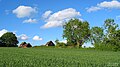
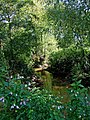
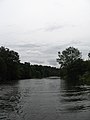
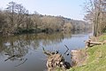
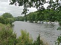
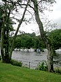
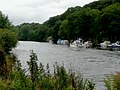
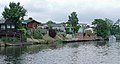
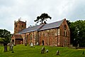
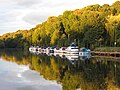
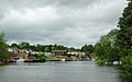
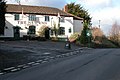
English: Shrawley is a village and civil parish in the Malvern Hills District in the county of Worcestershire, England. The village is situated on the western bank of the River Severn. The northern and southern boundaries of the parish are two small tributaries of the River Severn, Dick Brook to the north and Shrawley Brook to the south. To the west is Hillhampton, the north west and north is the parish of Astley and to the south Holt. (→Shrawley)
Nederlands: Shrawley is een plaats en civil parish in het bestuurlijke gebied Malvern Hills, in het Engelse graafschap Worcestershire. (→Shrawley)
Polski: Shrawley – wieś w Anglii, w hrabstwie Worcestershire, w dystrykcie Malvern Hills. Leży 11 km na północny zachód od miasta Worcester i 172 km na północny zachód od Londynu. (→Shrawley)

village and civil parish in the Malvern Hills District in the county of Worcestershire, England  | |||||
| Upload media | |||||
| Instance of | |||||
|---|---|---|---|---|---|
| Location | Malvern Hills, Worcestershire, West Midlands, England | ||||
 | |||||
Subcategories
This category has the following 3 subcategories, out of 3 total.
M
- St Mary's church, Shrawley (3 F)
S
- Shrawley War Memorial (4 F)
T
- The Lenchford Inn, Shrawley (8 F)
Media in category "Shrawley"
The following 187 files are in this category, out of 187 total.
-
 'River King' on the River Severn - geograph.org.uk - 3750895.jpg 1,600 × 1,136; 740 KB
-
 A bend in the B4196 road at Shrawley, Worcs - geograph.org.uk - 3433682.jpg 1,024 × 747; 207 KB
-
 Ancient coppiced woodland in Shrawley Wood - geograph.org.uk - 4145906.jpg 1,024 × 861; 395 KB
-
 Anemones in Shrawley Woods - Flickr - gailhampshire.jpg 3,712 × 2,088; 4.04 MB
-
 B4196 At The Lenchford Inn - geograph.org.uk - 1504542.jpg 640 × 480; 162 KB
-
 Barn of straw bales, Shrawley - geograph.org.uk - 140086.jpg 640 × 426; 127 KB
-
 Base of churchyard cross (geograph 5967988).jpg 1,024 × 768; 341 KB
-
 Bonefields Farm - geograph.org.uk - 4492346.jpg 1,600 × 1,200; 567 KB
-
 Bonefields Farm, Shrawley - geograph.org.uk - 5714180.jpg 1,280 × 720; 767 KB
-
 Caravan in Caldicotts Caravan Park - geograph.org.uk - 4501408.jpg 1,600 × 1,200; 419 KB
-
 Chalets by the River Severn from near Holt Fleet - geograph.org.uk - 6175136.jpg 1,600 × 1,200; 379 KB
-
 Church Cottage, Shrawley - geograph.org.uk - 6170631.jpg 3,323 × 2,209; 1.77 MB
-
 Copicing in Shrawley Woods - geograph.org.uk - 4447032.jpg 1,600 × 1,200; 777 KB
-
 Cottage Garden - geograph.org.uk - 4492177.jpg 1,600 × 1,200; 768 KB
-
 Dick Brook looking east from footbridge - geograph.org.uk - 1490159.jpg 480 × 640; 155 KB
-
-
 Dry Gully after dry spring - geograph.org.uk - 4492089.jpg 1,600 × 1,200; 614 KB
-
 East river bank of the River Severn - geograph.org.uk - 3751871.jpg 1,600 × 1,200; 665 KB
-
 Eastgrove Cottage Garden and Nursery - geograph.org.uk - 883773.jpg 640 × 480; 277 KB
-
 Eastgrove Cottage Garden and Nursery - geograph.org.uk - 883775.jpg 640 × 480; 303 KB
-
 Eastgrove Cottage Garden and Nursery - geograph.org.uk - 883780.jpg 640 × 480; 372 KB
-
-
 Electric Fence across Footpath - geograph.org.uk - 4492452.jpg 1,200 × 1,600; 742 KB
-
 Entrance to field - geograph.org.uk - 4501445.jpg 1,600 × 1,200; 406 KB
-
 Entrance-exit to Caldicotts Caravan Park - geograph.org.uk - 4501412.jpg 1,600 × 1,200; 633 KB
-
 Farm Building, Court Farm, Shrawley - geograph.org.uk - 1504463.jpg 640 × 480; 166 KB
-
 Farmland adjacent to Shrawley Wood - geograph.org.uk - 1484870.jpg 640 × 480; 110 KB
-
 Farmland adjacent to Shrawley Wood - geograph.org.uk - 1484879.jpg 640 × 472; 117 KB
-
 Fishing platform along the River Severn - geograph.org.uk - 3751860.jpg 1,200 × 1,600; 763 KB
-
 Fishing platform along the River Severn - geograph.org.uk - 3751890.jpg 1,600 × 1,200; 617 KB
-
 Foot bridge in Shrawley Wood - geograph.org.uk - 4446960.jpg 1,600 × 1,200; 782 KB
-
 Foot path gate and battery powered electric fence - geograph.org.uk - 4492261.jpg 1,600 × 1,200; 830 KB
-
 Footbridge into Shrawley Wood - geograph.org.uk - 4941345.jpg 1,600 × 1,200; 813 KB
-
 Footpath across field of cows - geograph.org.uk - 4492289.jpg 1,600 × 1,200; 315 KB
-
 Footpath and headland track - geograph.org.uk - 5967942.jpg 1,024 × 768; 257 KB
-
 Footpath Crossroads - geograph.org.uk - 4492395.jpg 1,600 × 1,200; 568 KB
-
 Footpath gate - geograph.org.uk - 4492228.jpg 1,600 × 1,200; 701 KB
-
 Footpath gate guarded by cow - geograph.org.uk - 4492325.jpg 1,600 × 1,200; 379 KB
-
 Footpath gate to path through caravan site - geograph.org.uk - 4492463.jpg 1,600 × 1,200; 607 KB
-
 Footpath in Shrawley Wood - geograph.org.uk - 2951269.jpg 1,600 × 1,200; 899 KB
-
 Footpath ringroad - geograph.org.uk - 4492220.jpg 1,600 × 1,200; 814 KB
-
 Footpath sign hidden in Leyland Cypress hedge - geograph.org.uk - 4498632.jpg 1,600 × 1,200; 663 KB
-
 Footpath To Frog Pool - geograph.org.uk - 1504492.jpg 640 × 480; 169 KB
-
 Gate and Stile - geograph.org.uk - 4446966.jpg 1,600 × 1,200; 621 KB
-
 Gateway to the dream of country living - geograph.org.uk - 4501468.jpg 1,200 × 1,600; 682 KB
-
 Glazen Bridge - geograph.org.uk - 4289539.jpg 640 × 480; 157 KB
-
 Goodyear's Farm - geograph.org.uk - 4492369.jpg 1,600 × 1,200; 535 KB
-

-
 Holders Pool Dummy Fisherman - geograph.org.uk - 4174142.jpg 1,024 × 436; 183 KB
-
 Horses in pasture - geograph.org.uk - 4501461.jpg 1,600 × 1,200; 649 KB
-
 Houses on B1496 Frog Pool, Shrawley, Worcestershire - geograph.org.uk - 4498655.jpg 1,600 × 1,200; 409 KB
-
 Houses on New Inn Lane - geograph.org.uk - 4492133.jpg 1,600 × 1,200; 463 KB
-
 Industrial Units near Dingle Cottages, Little Whitley - geograph.org.uk - 6205282.jpg 1,600 × 1,200; 418 KB
-
-
 Lane At Noutard's Green - geograph.org.uk - 1504498.jpg 640 × 480; 167 KB
-

-
 Lenchford Meadow Park - geograph.org.uk - 2867996.jpg 1,024 × 680; 126 KB
-
 Lenchford Meadow Park along the River Severn - geograph.org.uk - 3749782.jpg 1,600 × 1,200; 547 KB
-

-

-
 Main entrance to Shrawley Wood - geograph.org.uk - 1484798.jpg 640 × 471; 150 KB
-
 Main entrance to Shrawley Wood - geograph.org.uk - 1484824.jpg 640 × 469; 159 KB
-
 Messing about on the River - geograph.org.uk - 2302895.jpg 800 × 624; 328 KB
-
 Mobile homes near Doleham Bridge - geograph.org.uk - 5699235.jpg 5,700 × 3,800; 7.27 MB
-
 Mound in pasture - geograph.org.uk - 4492248.jpg 1,600 × 1,200; 316 KB
-
 Muck bury, near Boreley House - geograph.org.uk - 133229.jpg 640 × 426; 132 KB
-
 New build on New Inn Lane - geograph.org.uk - 4492151.jpg 1,600 × 1,200; 410 KB
-
 New build, New Inn Lane - geograph.org.uk - 4492197.jpg 1,600 × 1,200; 499 KB
-
 New Inn Lane, Shrawley - geograph.org.uk - 4492114.jpg 1,600 × 1,200; 619 KB
-
 New Pool, Shrawley Wood - geograph.org.uk - 1535674.jpg 480 × 640; 72 KB
-
 No caravan in sight - geograph.org.uk - 4501378.jpg 1,600 × 1,200; 408 KB
-
 No Parking At The Phone Box - geograph.org.uk - 1504478.jpg 640 × 480; 204 KB
-
 On the site of the former Rose and Crown - geograph.org.uk - 4915468.jpg 1,600 × 1,200; 369 KB
-
 Park homes on the west bank of the Severn - geograph.org.uk - 3158416.jpg 1,024 × 768; 108 KB
-

-
 Path on the edge of Shrawley Wood - geograph.org.uk - 1484913.jpg 640 × 476; 152 KB
-
 Path through conifers in Shrawley Wood - geograph.org.uk - 4447057.jpg 1,600 × 1,200; 711 KB
-
 Path through Shrawley Wood - geograph.org.uk - 1484935.jpg 640 × 480; 165 KB
-
 Path to Shrawley Woods - geograph.org.uk - 4915482.jpg 1,600 × 1,200; 847 KB
-
 Ploughed over footpath near Shrawley Woods - geograph.org.uk - 4915461.jpg 1,600 × 1,200; 544 KB
-
-
 Ramsons in Shrawley Wood - geograph.org.uk - 4491520.jpg 1,600 × 1,200; 869 KB
-
-
 River Severn above Holt Fleet - geograph.org.uk - 905459.jpg 640 × 428; 95 KB
-
 River Severn above Holt Fleet - geograph.org.uk - 905469.jpg 640 × 428; 94 KB
-
 River Severn above Holt Fleet - geograph.org.uk - 905474.jpg 640 × 428; 80 KB
-

-

-
 River Severn crossed by electricity cables - geograph.org.uk - 2049073.jpg 2,304 × 3,072; 2.58 MB
-

-
 River Severn near Shrawley - geograph.org.uk - 2868455.jpg 1,024 × 680; 203 KB
-
 River Severn near Shrawley - geograph.org.uk - 5092884.jpg 1,280 × 960; 467 KB
-

-

-
-

-
-

-
-
 River-side homes near Shrawley, Worcestershire - geograph.org.uk - 3749328.jpg 1,280 × 683; 670 KB
-
 River-side homes near Shrawley, Worcestershire - geograph.org.uk - 3749490.jpg 1,024 × 663; 584 KB
-
 River-side homes near Shrawley, Worcestershire - geograph.org.uk - 3749492.jpg 1,280 × 677; 587 KB
-
 Riverside park homes and their moorings - geograph.org.uk - 3157985.jpg 1,024 × 768; 99 KB
-

-
 Road approaching Burf Cottages, The Burf - geograph.org.uk - 111546.jpg 640 × 426; 136 KB
-
 Road to Hazlehurst Farm, Little Witley, Worcestershire - geograph.org.uk - 6205281.jpg 1,600 × 1,200; 290 KB
-
 Sankyns Green Crossroads, Looking East - geograph.org.uk - 1504425.jpg 640 × 480; 184 KB
-
 Scarecrow in a field of Cabbages - geograph.org.uk - 4145881.jpg 1,024 × 683; 282 KB
-
 Seat near stepping tones in Shrawley Woods - geograph.org.uk - 4446975.jpg 1,600 × 1,200; 775 KB
-
 Shrawley church - geograph.org.uk - 5967936.jpg 1,024 × 768; 215 KB
-
 Shrawley Wood - geograph.org.uk - 2951277.jpg 1,600 × 1,200; 888 KB
-
 Shrawley Wood House - geograph.org.uk - 139525.jpg 640 × 426; 157 KB
-
 Shrawley Woods - geograph.org.uk - 2951283.jpg 1,200 × 1,600; 872 KB
-
 Sign for the New Inn, Noutard's Green - geograph.org.uk - 4501452.jpg 1,600 × 1,200; 478 KB
-
 Silver Fox heading down the River Severn - geograph.org.uk - 3158498.jpg 1,024 × 768; 134 KB
-
 Small streamlet crosses path - geograph.org.uk - 4492084.jpg 1,600 × 1,200; 706 KB
-
 St Mary, Shrawley - geograph.org.uk - 6169952.jpg 3,683 × 1,993; 1.95 MB
-
 St Mary, Shrawley - geograph.org.uk - 6170008.jpg 3,320 × 2,211; 1.83 MB
-
 St Mary, Shrawley - geograph.org.uk - 6170649.jpg 3,323 × 2,209; 2.01 MB
-
 St Mary, Shrawley - geograph.org.uk - 6170725.jpg 2,092 × 3,509; 2.46 MB
-
 St Mary, Shrawley - geograph.org.uk - 6170794.jpg 2,209 × 3,323; 2.04 MB
-
 St Mary, Shrawley - geograph.org.uk - 6170812.jpg 3,323 × 2,209; 2.41 MB
-
 St Mary, Shrawley - geograph.org.uk - 6171655.jpg 2,986 × 2,458; 1.97 MB
-
 St Mary, Shrawley - geograph.org.uk - 6171662.jpg 2,765 × 2,655; 1,006 KB
-
 St Mary, Shrawley - geograph.org.uk - 6173115.jpg 2,929 × 2,506; 1.2 MB
-
 St Mary, Shrawley - geograph.org.uk - 6173152.jpg 2,209 × 3,323; 1.76 MB
-
 St Mary, Shrawley - geograph.org.uk - 6173168.jpg 2,466 × 2,976; 1.47 MB
-
 St Mary, Shrawley - geograph.org.uk - 6173177.jpg 2,274 × 3,227; 1.46 MB
-
 St Mary, Shrawley - geograph.org.uk - 6173185.jpg 2,209 × 3,323; 1.7 MB
-
 St Mary, Shrawley - geograph.org.uk - 6173195.jpg 3,045 × 2,411; 2.38 MB
-
 St Mary, Shrawley - geograph.org.uk - 6173206.jpg 2,376 × 3,090; 2.32 MB
-
 St Mary, Shrawley - geograph.org.uk - 6173208.jpg 3,765 × 1,950; 2.69 MB
-
 St Mary, Shrawley - geograph.org.uk - 6173213.jpg 2,315 × 3,171; 1.92 MB
-
 St Mary, Shrawley - geograph.org.uk - 6173466.jpg 2,481 × 2,958; 2.25 MB
-
 St Mary, Shrawley - geograph.org.uk - 6173471.jpg 2,041 × 3,597; 2.08 MB
-
 St Mary, Shrawley - geograph.org.uk - 6173481.jpg 2,049 × 3,582; 1.58 MB
-
 Stained glass windows, Shrawley - geograph.org.uk - 5967992.jpg 1,024 × 1,024; 223 KB
-
 Stand Of Trees, Shrawley Wood - geograph.org.uk - 1504501.jpg 640 × 480; 242 KB
-
 Stepping stones, Shrawley Wood - geograph.org.uk - 139039.jpg 426 × 640; 148 KB
-
 Stile footpath at caravan site entrance - geograph.org.uk - 4501431.jpg 1,600 × 1,200; 537 KB
-
 Stile on path to Glasshampton Monastery - geograph.org.uk - 4492424.jpg 1,600 × 1,200; 377 KB
-
 Supersize bog garden - geograph.org.uk - 4915498.jpg 1,600 × 1,200; 743 KB
-
 Telephone Box and Bus Stop - geograph.org.uk - 4498639.jpg 1,600 × 1,200; 541 KB
-
 Telephone box near the Frog Pool - geograph.org.uk - 4915478.jpg 1,600 × 1,228; 633 KB
-

-

-

-

-
 The former Rose ^ Crown (1), at Shrawley, Worcs - geograph.org.uk - 3431880.jpg 1,024 × 739; 177 KB
-
 The former Rose ^ Crown (2), at Shrawley, Worcs - geograph.org.uk - 3431892.jpg 1,024 × 728; 180 KB
-
 The Hollies, Boreley - geograph.org.uk - 133237.jpg 640 × 426; 124 KB
-
 The New Inn pub sign, Shrawley - geograph.org.uk - 1484770.jpg 496 × 640; 117 KB
-
 The New Inn, Noutard's Green - geograph.org.uk - 1504512.jpg 640 × 480; 158 KB
-
 The River Severn at The Burf - geograph.org.uk - 111549.jpg 640 × 426; 130 KB
-
 The River Severn below Lythe Farm - geograph.org.uk - 5696801.jpg 6,000 × 4,000; 7.28 MB
-

-
 The River Severn by Shrawley Wood,Worcestershire - geograph.org.uk - 3748462.jpg 1,024 × 684; 418 KB
-

-
 The River Severn near the Lenchford Inn - geograph.org.uk - 5137004.jpg 4,000 × 3,000; 4.03 MB
-

-
-

-
 The start of a private drive at Shrawley, Worcs - geograph.org.uk - 3433762.jpg 1,024 × 754; 307 KB
-

-
 Top of New Inn Lane - geograph.org.uk - 4492208.jpg 1,600 × 1,200; 796 KB
-
 Tractor tracks in a ploughed field - geograph.org.uk - 4915491.jpg 1,600 × 1,200; 608 KB
-
 Trailer on farmland - geograph.org.uk - 5967975.jpg 1,024 × 768; 227 KB
-

-
 Trees and farmland by the River Severn - geograph.org.uk - 5698507.jpg 6,000 × 4,000; 4.92 MB
-
 Trees reflected in the River Severn - geograph.org.uk - 5698513.jpg 5,358 × 3,572; 7.19 MB
-
 View down the Severn - geograph.org.uk - 3158453.jpg 1,024 × 768; 137 KB
-
 View North From Sankyns Green Crossroads - geograph.org.uk - 1504429.jpg 640 × 480; 254 KB
-
 View overlooking fields from Shrawley Wood - geograph.org.uk - 2951264.jpg 1,600 × 1,200; 495 KB
-
 Wooden fishing platform along the River Severn - geograph.org.uk - 3750865.jpg 1,600 × 1,207; 1,007 KB
-

-
 Dick Brook from footbridge - geograph.org.uk - 139519.jpg 426 × 640; 142 KB
-
 Edge of Areley Kings - geograph.org.uk - 218636.jpg 640 × 480; 39 KB
-
 Footbridge over Dick Brook - geograph.org.uk - 139517.jpg 640 × 426; 178 KB
-
 Holinshead farm - geograph.org.uk - 140933.jpg 640 × 377; 40 KB
-
 Longmore Hill Farm - geograph.org.uk - 111552.jpg 640 × 426; 122 KB
-
 New Pool, Shrawley Wood - geograph.org.uk - 139521.jpg 640 × 426; 110 KB
-
 Ploughed field at near Lineholt - geograph.org.uk - 133665.jpg 640 × 426; 127 KB
-

-
 Stile near Brant House Farm - geograph.org.uk - 140080.jpg 640 × 426; 126 KB
-
 The New Inn, Shrawley - geograph.org.uk - 111545.jpg 640 × 426; 110 KB
-
 The River Severn, Shrawley - geograph.org.uk - 140088.jpg 640 × 426; 133 KB
-
 The Rose and Crown, Shrawley - geograph.org.uk - 140081.jpg 640 × 426; 95 KB


.jpg)


,_at_Shrawley,_Worcs_-_geograph.org.uk_-_3431880.jpg)
,_at_Shrawley,_Worcs_-_geograph.org.uk_-_3431892.jpg)


