Category:Siedlungskirche Elstal
| Object location | | View all coordinates using: OpenStreetMap |
|---|
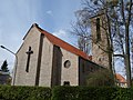
church building in Brandenburg state, Germany  | |||||
| Upload media | |||||
| Instance of | |||||
|---|---|---|---|---|---|
| Location | Elstal, Wustermark, Havelland District, Brandenburg, Germany | ||||
| Architect |
| ||||
| Heritage designation | |||||
| Inception |
| ||||
 | |||||
This is the category of the Brandenburger Baudenkmal (cultural heritage monument) with the ID 09150711 (Wikidata)
|
Deutsch: Kirche der Eisenbahnersiedlung Elstal, Gemeinde Wustermark, Landkreis Havelland, Land Brandenburg, Deutschland.
Français : Église de Elstal, commune de Wustermark, arrondissement Pays de la Havel, état fédéral de Brandebourg, Allemagne
Media in category "Siedlungskirche Elstal"
The following 9 files are in this category, out of 9 total.
-
 Elstal church 2011 W.jpg 2,560 × 1,920; 2.99 MB
-
 Elstal church 2016 E.jpg 4,684 × 4,705; 10.81 MB
-
 Elstal church 2016 ENE.jpg 4,864 × 3,648; 7.26 MB
-
 Elstal church 2016 N.jpg 4,864 × 3,648; 9.28 MB
-
 Elstal church 2016 NW.jpg 3,190 × 3,705; 6.29 MB
-
 Elstal church 2016 portal W.jpg 3,648 × 4,864; 6.84 MB
-
 Elstal church 2016 S.jpg 6,115 × 3,491; 10.31 MB
-
 Elstal church 2016 SE.jpg 4,864 × 3,648; 6.84 MB
-
 Elstal church 2016 SSW.jpg 4,118 × 3,820; 6.67 MB


