Category:Sint-Lambertuskerk (Buren)
| Object location | | View all coordinates using: OpenStreetMap |
|---|
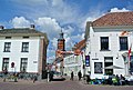
Nederlands: Afbeeldingen van de Sint-Lambertuskerk (Buren), Markt 4, 4116 BE Buren. Gelegen in Buren in de provincie Gelderland in Nederland
English: Pictures of the Sint-Lambertuschurch, Markt 4, 4116 BE Buren. In Buren in the Dutch province of Gelderland in the Netherlands
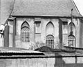
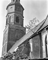
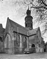
church building in Buren, Netherlands  | |||||
| Upload media | |||||
| Instance of | |||||
|---|---|---|---|---|---|
| Named after | |||||
| Location | Buren, Gelderland, Netherlands | ||||
| Street address |
| ||||
| Architectural style | |||||
| Heritage designation |
| ||||
| Inception |
| ||||
| Significant event |
| ||||
| Religion or worldview | |||||
 | |||||
Kerk
|
This is a category about rijksmonument number 11329
|
Toren
|
This is a category about rijksmonument number 11330
|
Subcategories
This category has the following 4 subcategories, out of 4 total.
Media in category "Sint-Lambertuskerk (Buren)"
The following 80 files are in this category, out of 80 total.
-
 4116 Buren, Netherlands - panoramio (11).jpg 1,375 × 2,048; 524 KB
-
 4116 Buren, Netherlands - panoramio (12).jpg 2,048 × 1,375; 432 KB
-
 4116 Buren, Netherlands - panoramio (14).jpg 1,375 × 2,048; 403 KB
-
 4116 Buren, Netherlands - panoramio (15).jpg 2,048 × 1,375; 478 KB
-
 4116 Buren, Netherlands - panoramio (17).jpg 1,375 × 2,048; 442 KB
-
 4116 Buren, Netherlands - panoramio (31).jpg 2,048 × 1,148; 300 KB
-
 4116 Buren, Netherlands - panoramio (39).jpg 1,148 × 2,048; 494 KB
-
 4116 Buren, Netherlands - panoramio (92).jpg 4,896 × 3,264; 2.25 MB
-
 4116 Buren, Netherlands - panoramio - Ben Bender (17).jpg 4,896 × 3,264; 5.3 MB
-
 4116 Buren, Netherlands - panoramio - Ben Bender (23).jpg 4,896 × 3,264; 5.08 MB
-
 4116 Buren, Netherlands - panoramio - Ben Bender (7).jpg 4,896 × 3,264; 4.79 MB
-
 Aanzicht westgevel noordportaal - Buren - 20045359 - RCE.jpg 961 × 1,200; 291 KB
-
 B12.gif 384 × 512; 110 KB
-
 Buren gezien vanaf de Tielseweg.jpg 4,770 × 3,177; 2.79 MB
-
 BUREN ST. LAMBERTUSKERK 02.jpg 3,342 × 4,456; 3.66 MB
-
 BUREN ST. LAMBERTUSKERK 04.jpg 4,608 × 3,456; 2.58 MB
-
 BUREN ST. LAMBERTUSKERK 05.jpg 4,608 × 3,456; 5 MB
-
 BUREN ST. LAMBERTUSKERK 06.jpg 4,608 × 3,456; 4.19 MB
-
 Buren, mooi gelegen in de voorjaarszon.jpg 4,770 × 3,177; 2.5 MB
-
 De kerk te Buren, RP-T-1888-A-1606.jpg 4,142 × 5,686; 2.8 MB
-
 Exterieur - Buren - 20045347 - RCE.jpg 965 × 1,200; 201 KB
-
 Exterieur - Buren - 20045348 - RCE.jpg 960 × 1,200; 261 KB
-
 Exterieur - Buren - 20045349 - RCE.jpg 1,200 × 967; 267 KB
-
 Exterieur koor - Buren - 20045420 - RCE.jpg 788 × 1,200; 243 KB
-
 Exterieur naar het noord-westen - Buren - 20045334 - RCE.jpg 1,200 × 951; 349 KB
-
 Exterieur noord-zijde naar het zuid-westen - Buren - 20045335 - RCE.jpg 1,200 × 932; 285 KB
-

-
 Exterieur, vanaf Kerkstraat - Buren - 20045350 - RCE.jpg 960 × 1,200; 240 KB
-

-
 Gewelf in toren - Buren - 20045375 - RCE.jpg 955 × 1,200; 166 KB
-

-
 Gezicht van af Weeshuis wal - Buren - 20045093 - RCE.jpg 1,200 × 1,178; 355 KB
-
 Ingang - Buren - 20325692 - RCE.jpg 809 × 1,200; 218 KB
-
 Interieur zuiderzijbeuk naar het westen - Buren - 20045367 - RCE.jpg 959 × 1,200; 148 KB
-

-
 Interieur, hardstenen grafzerk - Buren - 20045344 - RCE.jpg 886 × 1,200; 209 KB
-
 Kerk van Buren.jpg 3,072 × 2,304; 1.14 MB
-
 Markt - Buren - 20045727 - RCE.jpg 957 × 1,200; 215 KB
-

-
 Noord-gevel - Buren - 20045479 - RCE.jpg 1,198 × 1,200; 331 KB
-
 Noord-gevel - Buren - 20045480 - RCE.jpg 1,200 × 1,199; 361 KB
-
 Noord-oost gevel - Buren - 20045351 - RCE.jpg 1,200 × 949; 228 KB
-
 Noordgevel - Buren - 20045352 - RCE.jpg 960 × 1,200; 284 KB
-
 Noordgevel koor - Buren - 20045353 - RCE.jpg 1,200 × 956; 249 KB
-
 Noordgevel koor - Buren - 20045399 - RCE.jpg 1,200 × 804; 277 KB
-
 Noordzijde kolom noordzijde koor - Buren - 20045393 - RCE.jpg 804 × 1,200; 270 KB
-
 Onderste deel westgevel - Buren - 20324451 - RCE.jpg 1,200 × 864; 179 KB
-
 Onderzoek ten noorden van het schip tekening R.O.B. - Buren - 20045471 - RCE.jpg 1,200 × 942; 224 KB
-
 Oost gevel - Buren - 20045481 - RCE.jpg 1,200 × 1,197; 317 KB
-
 Oost gevel - Buren - 20045482 - RCE.jpg 1,190 × 1,200; 311 KB
-
 Oostgedeelte koor - Buren - 20045371 - RCE.jpg 1,200 × 957; 233 KB
-
 Oostgevel - Buren - 20045354 - RCE.jpg 1,200 × 956; 208 KB
-
 Overzicht kap gezien naar het oosten - Buren - 20045405 - RCE.jpg 1,200 × 799; 226 KB
-
 Peperstraat 13-25, Buren.jpg 4,896 × 3,264; 2.02 MB
-
 Portaal noordgevel - Buren - 20045355 - RCE.jpg 1,200 × 956; 235 KB
-
 Protestant church of Buren at 24 April 2015 - panoramio.jpg 4,288 × 2,848; 5.88 MB
-
 Raam zuidgevel koor - Buren - 20045401 - RCE.jpg 787 × 1,200; 187 KB
-

-
 RM 11330-toren St.Lambertuskerk.jpg 2,700 × 3,137; 2.21 MB
-
 Sint-Lambertuskerk-Buren-Nederland.jpg 1,152 × 2,048; 654 KB
-

-
 Tekening grondprofielen tekening R.O.B. - Buren - 20045472 - RCE.jpg 1,200 × 944; 208 KB
-
 Tekening vlak 3 reproductie R.O.B. - Buren - 20045468 - RCE.jpg 955 × 1,200; 214 KB
-
 Tekening vlak 4 reproductie R.O.B. - Buren - 20045469 - RCE.jpg 957 × 1,200; 222 KB
-
 Tekening voor bestemingsplan - Buren - 20045473 - RCE.jpg 1,200 × 958; 152 KB
-
 Toren - Buren - 20045329 - RCE.jpg 759 × 1,200; 180 KB
-
 Uit het zuid-westen - Buren - 20045732 - RCE.jpg 1,200 × 812; 230 KB
-
 Waag tegen de kerk aan gebouwd - Buren - 20325781 - RCE.jpg 1,200 × 914; 217 KB
-

-
 Zicht op St.Lambertuskerk RM 11329.jpg 2,736 × 3,648; 2.79 MB
-
 Zicht vanuit het noordoosten - Buren - 20326468 - RCE.jpg 853 × 1,200; 120 KB
-
 Zuid zijbeuk naar het westen - Buren - 20045494 - RCE.jpg 1,192 × 1,200; 169 KB
-
 Zuid-gevel - Buren - 20045483 - RCE.jpg 1,192 × 1,200; 339 KB
-
 Zuid-gevel - Buren - 20045484 - RCE.jpg 1,192 × 1,200; 390 KB
-
 Zuid-oost aanzicht - Buren - 20045337 - RCE.jpg 884 × 1,200; 149 KB
-
 Zuid-zijde koor - Buren - 20045485 - RCE.jpg 1,195 × 1,200; 343 KB
-
 Zuidgevel - Buren - 20045356 - RCE.jpg 1,200 × 942; 310 KB
-
 Zuidgevel koor - Buren - 20045357 - RCE.jpg 1,200 × 953; 244 KB
-
 Zuidgevel koor - Buren - 20045358 - RCE.jpg 947 × 1,200; 279 KB
-
 Zuidhoek koor met schip - Buren - 20045414 - RCE.jpg 804 × 1,200; 264 KB
.jpg)
.jpg)
.jpg)
.jpg)
.jpg)
.jpg)
.jpg)
.jpg)
.jpg)
.jpg)
.jpg)


