Category:St. Kilian (Iserlohn)
| Object location | | View all coordinates using: OpenStreetMap |
|---|
church  | |||||
| Upload media | |||||
| Instance of | |||||
|---|---|---|---|---|---|
| Named after | |||||
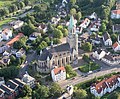
| Location | Iserlohn, Märkischer Kreis, Arnsberg Government Region, North Rhine-Westphalia, Germany | ||||
| Architectural style | |||||
| Architect | |||||
| Inception |
| ||||
 | |||||
Subcategories
This category has the following 2 subcategories, out of 2 total.
A
S
- St. Kilian intern (Iserlohn) (15 F)
Media in category "St. Kilian (Iserlohn)"
The following 15 files are in this category, out of 15 total.
-
 Iserlohn st kilian p1010066.jpg 1,491 × 1,227; 1,011 KB
-
 Iserlohn St. Kilian von Norden.jpg 3,700 × 3,900; 2.91 MB
-
 Letmathe-Kiliansdom1-Asio.JPG 995 × 1,266; 298 KB
-
 Letmathe-Kiliansdom10-Asio.JPG 1,944 × 2,592; 2.82 MB
-
 Letmathe-Kiliansdom11-Asio.JPG 1,944 × 2,592; 3.41 MB
-
 Letmathe-Kiliansdom12-Asio.JPG 2,592 × 1,944; 3.3 MB
-
 Letmathe-Kiliansdom14-Asio.jpg 2,127 × 1,418; 958 KB
-
 Letmathe-Kiliansdom2-Asio.JPG 1,926 × 2,544; 1.14 MB
-
 Letmathe-Kiliansdom3-Asio.JPG 1,790 × 2,731; 2.4 MB
-
 Letmathe-Kiliansdom4-Asio.JPG 1,944 × 2,592; 2.59 MB
-
 Letmathe-Kiliansdom5-Asio.JPG 1,944 × 2,592; 1.95 MB
-
 Letmathe-Kiliansdom6-Asio.JPG 1,944 × 2,592; 2.63 MB
-
 Letmathe-Kiliansdom7-Asio.JPG 1,944 × 2,592; 2.64 MB
-
 Letmathe-Kiliansdom8-Asio.JPG 2,592 × 1,944; 2.79 MB
-
 Letmathe-Kiliansdom9-Asio.JPG 1,944 × 2,592; 2.53 MB


