Category:St. Michael (Tröbitz)
| Object location | | View all coordinates using: OpenStreetMap |
|---|
church building in Elbe-Elster district, Brandenburg state, Germany  _21.JPG) | |||||
| Upload media | |||||
| Instance of | |||||
|---|---|---|---|---|---|
| Location | Tröbitz, Elbe-Elster District, Brandenburg, Germany | ||||
| Street address |
| ||||
| Inception |
| ||||
| Religion or worldview | |||||
 | |||||
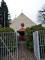
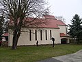
English: Pictures of the Roman Catholic church "St.Michael" in Tröbitz, Tröbitz municipality, Elbe-Elster district, Brandenburg state, Germany.
Deutsch: Ansichten der katholischen Kirche "St.Michael" in Tröbitz, Gemeinde Tröbitz , Landkreis Elbe-Elster , Land Brandenburg , Deutschland.
Français : Photos de l'église catholique "St.Michael" à Tröbitz, commune de Tröbitz, , arrondissement de Elbe-Elster , état federé de Brandebourg , Allemagne.
Español: Vistas de la iglesia católica "St.Michael" en Tröbitz, municipio de Tröbitz, distrito de Elbe-Elster , estado federado de Brandeburgo , Alemania.
Address: Anliegerweg 2, 03253 Tröbitz
Subcategories
This category has the following 3 subcategories, out of 3 total.
Media in category "St. Michael (Tröbitz)"
The following 19 files are in this category, out of 19 total.
-
 Kath. Kirche St. Michael, Tröbitz 2014 (Alter Fritz) 01.JPG 3,313 × 2,488; 4.09 MB
-
 Kath. Kirche St. Michael, Tröbitz 2014 (Alter Fritz) 04.JPG 3,448 × 4,592; 7.64 MB
-
 Kath. Kirche St. Michael, Tröbitz 2014 (Alter Fritz) 05.JPG 3,448 × 4,592; 7.59 MB
-
 Kath. Kirche St. Michael, Tröbitz 2014 (Alter Fritz) 06.JPG 3,448 × 4,592; 7.34 MB
-
 Kath. Kirche St. Michael, Tröbitz 2014 (Alter Fritz) 07.JPG 3,448 × 4,592; 7.68 MB
-
 Kath. Kirche St. Michael, Tröbitz 2014 (Alter Fritz) 08.JPG 3,448 × 4,592; 6.36 MB
-
 Kath. Kirche St. Michael, Tröbitz 2014 (Alter Fritz) 09.JPG 3,448 × 4,592; 7.52 MB
-
 Kath. Kirche St. Michael, Tröbitz 2014 (Alter Fritz) 11.JPG 4,592 × 3,448; 8.2 MB
-
 Kath. Kirche St. Michael, Tröbitz 2014 (Alter Fritz) 12.JPG 4,592 × 3,448; 8.86 MB
-
 Kath. Kirche St. Michael, Tröbitz 2014 (Alter Fritz) 13.JPG 4,592 × 3,448; 8.48 MB
-
 Kath. Kirche St. Michael, Tröbitz 2014 (Alter Fritz) 14.JPG 4,592 × 3,448; 7.83 MB
-
 Kath. Kirche St. Michael, Tröbitz 2014 (Alter Fritz) 15.JPG 4,592 × 3,448; 3.71 MB
-
 Kath. Kirche St. Michael, Tröbitz 2014 (Alter Fritz) 16.JPG 4,592 × 3,448; 8.23 MB
-
 Kath. Kirche St. Michael, Tröbitz 2014 (Alter Fritz) 17.JPG 4,592 × 3,448; 8.32 MB
-
 Kath. Kirche St. Michael, Tröbitz 2014 (Alter Fritz) 23.JPG 4,592 × 3,448; 8.48 MB
-
 Kath Kir Troebitz 2.jpg 2,013 × 1,835; 637 KB
-
 Kath Kir Troebitz 3.jpg 2,304 × 3,072; 1.02 MB
-
 Kath Kir Troebitz 4.jpg 2,304 × 3,072; 824 KB
-
 Kath Kir Troebitz.jpg 1,469 × 1,653; 491 KB
_01.JPG)
_04.JPG)
_05.JPG)
_06.JPG)
_07.JPG)
_08.JPG)
_09.JPG)
_11.JPG)
_12.JPG)
_13.JPG)
_14.JPG)
_15.JPG)
_16.JPG)
_17.JPG)
_23.JPG)


