Category:St Wilfrid's Church, Burnsall
| Object location | | View all coordinates using: OpenStreetMap |
|---|
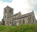
Grade I listed church in Burnsall, North Yorkshire, United Kingdom  | |||||
| Upload media | |||||
| Instance of | |||||
|---|---|---|---|---|---|
| Dedicated to | |||||
| Location | Burnsall, Craven, North Yorkshire, Yorkshire and the Humber, England | ||||
| Diocese | |||||
| Heritage designation |
| ||||
| Inception |
| ||||
| Religion or worldview | |||||
 | |||||
Subcategories
This category has the following 2 subcategories, out of 2 total.
Media in category "St Wilfrid's Church, Burnsall"
The following 51 files are in this category, out of 51 total.
-
 'sir willm craven knight'.jpg 2,206 × 1,472; 1.18 MB
-

-
 Burnsall Church - geograph.org.uk - 747890.jpg 640 × 426; 66 KB
-
 Burnsall church and village - geograph.org.uk - 1724597.jpg 2,048 × 1,536; 1.13 MB
-
 Burnsall from Skuff Road - geograph.org.uk - 2505171.jpg 631 × 640; 71 KB
-
 Burnsall, Church of St Wilfrid, looking east, GeoUK4605194.jpg 1,062 × 1,400; 1.03 MB
-
 BURNSALL, St Wilfrid (35636269493).jpg 1,739 × 2,575; 2.39 MB
-
 Burnsall, St. Wilfrid's Church - geograph.org.uk - 6233690.jpg 5,961 × 3,974; 5.24 MB
-
 Burnsall, St. Wilfrid's Church - geograph.org.uk - 6233692.jpg 6,911 × 4,607; 6.77 MB
-

-

-
 Burnsall, St. Wilfrid's Church, c17th altar table - geograph.org.uk - 6233740.jpg 6,393 × 4,262; 5.79 MB
-

-

-

-
 Burnsall, St. Wilfrid's Church, Norman font (detail) - geograph.org.uk - 6233705.jpg 6,575 × 4,383; 7.76 MB
-
 Burnsall, St. Wilfrid's Church, Norman font - geograph.org.uk - 6233703.jpg 5,811 × 3,873; 5.53 MB
-
 Burnsall, St. Wilfrid's Church, Rood screen from the chancel - geograph.org.uk - 6233737.jpg 7,127 × 4,751; 5.61 MB
-
 Burnsall, St. Wilfrid's Church, Roof corbel - geograph.org.uk - 6233733.jpg 6,400 × 4,267; 6.7 MB
-
 Burnsall, St. Wilfrid's Church, Royal Coat of Arms - geograph.org.uk - 6233714.jpg 6,874 × 4,583; 6.5 MB
-
 Burnsall, St. Wilfrid's Church, Simple sundial - geograph.org.uk - 6233699.jpg 6,319 × 4,212; 6.27 MB
-
 Burnsall, St. Wilfrid's Church, The nave - geograph.org.uk - 6233709.jpg 6,779 × 4,519; 5.08 MB
-
 Burnsall, St. Wilfrid's Church, The nave and chancel - geograph.org.uk - 6233746.jpg 7,196 × 4,797; 6.39 MB
-
 Burnsall, St. Wilfrid's Churchyard - geograph.org.uk - 6233697.jpg 6,094 × 4,063; 7.18 MB
-

-
 Church of St Wilfred, Burnsall - geograph.org.uk - 4717898.jpg 3,776 × 2,520; 4.04 MB
-
 Church of St Wilfrid, Burnsall - geograph.org.uk - 4183887.jpg 640 × 430; 61 KB
-
 Church of St Wilfrid, Burnsall - geograph.org.uk - 4183890.jpg 640 × 430; 64 KB
-
 Church of St Wilfrid, Burnsall - geograph.org.uk - 4605190.jpg 1,600 × 1,067; 1.17 MB
-
 Church, Burnsall - geograph.org.uk - 2465690.jpg 1,200 × 1,600; 354 KB
-
 Font in Burnsall Church, North Yorkshire (O57813).jpg 768 × 606; 85 KB
-
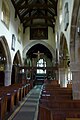 Inside the Church of St Wilfrid, Burnsall - geograph.org.uk - 4605194.jpg 1,067 × 1,600; 1.19 MB
-
 Lych Gate, St. Wilfred's Church, Burnsall - geograph.org.uk - 409390.jpg 640 × 480; 113 KB
-
 School & Church - geograph.org.uk - 388019.jpg 600 × 400; 92 KB
-
 St Wilfred's Church - geograph.org.uk - 5873302.jpg 1,600 × 1,200; 673 KB
-
 St Wilfrid Church, Burnsall, Yorkshire - geograph.org.uk - 3758954.jpg 1,024 × 681; 288 KB
-
 St Wilfrid Church, Burnsall, Yorkshire - geograph.org.uk - 3758982.jpg 1,024 × 681; 286 KB
-
 St Wilfrid Church, Burnsall, Yorkshire - geograph.org.uk - 3758984.jpg 1,024 × 681; 343 KB
-
 St Wilfrid's Church and Burnsall Primary School - geograph.org.uk - 5301537.jpg 5,152 × 3,864; 7.68 MB
-
 St Wilfrid's Church, Burnsall - geograph.org.uk - 239574.jpg 457 × 639; 61 KB
-
 St Wilfrid's Church, Burnsall - geograph.org.uk - 4406133.jpg 3,648 × 2,736; 4.68 MB
-
 St Wilfrid's lychgate - geograph.org.uk - 4406119.jpg 3,648 × 2,736; 4.85 MB
-
 St Wilfrid's tower, east view.jpg 1,598 × 1,836; 1.93 MB
-
 St Wilfrid, Burnsall.jpg 2,847 × 2,480; 4.58 MB
-
 St. Wilfrid's, Burnsall - geograph.org.uk - 3589340.jpg 1,024 × 768; 481 KB
-
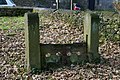 Stocks at St Wilfrid Church, Burnsall, Yorkshire - geograph.org.uk - 3758991.jpg 1,024 × 681; 440 KB
-
 The Church of St Wilfred at Burnsall - geograph.org.uk - 3947474.jpg 4,000 × 3,000; 2.47 MB
-
 The Lychgate at St Wilfrid Church, Burnsall - geograph.org.uk - 3758959.jpg 1,024 × 681; 294 KB
-
 The Lychgate at St Wilfrid Church, Burnsall - geograph.org.uk - 3758964.jpg 1,024 × 681; 351 KB
-

-
 The War Memorial at Burnsall, Yorkshire - geograph.org.uk - 3758966.jpg 681 × 1,024; 327 KB

.jpg)


.jpg)


_-_geograph.org.uk_-_6233705.jpg)


.jpg)


.jpg)


