Category:Stanton, Staffordshire
English: Stanton is a small village situated at the eastern end of the Weaver Hills, Staffordshire, England. Stanton is located east of Stoke-on-Trent. It has a population of 232 according to the 2001 Census. Stanton is a District/Unitary Authority. The landscape around the village is mainly pastureland bounded by dry stone walls.
Polski: Stanton – niewielka wieś i civil parish w Anglii, w Staffordshire, w dystrykcie East Staffordshire. W 2011 roku civil parish liczyła 259 mieszkańców. Stanton jest wspomniana w Domesday Book (1086) jako Stantone.

village and civil parish in Staffordshire, England  | |||||
| Upload media | |||||
| Instance of | |||||
|---|---|---|---|---|---|
| Location | East Staffordshire, Staffordshire, West Midlands, England | ||||
| Different from | |||||
 | |||||
Subcategories
This category has only the following subcategory.
Media in category "Stanton, Staffordshire"
The following 58 files are in this category, out of 58 total.
-
 A52 near Calton Moor - geograph.org.uk - 1837609.jpg 640 × 480; 39 KB
-
 Abandoned barn - geograph.org.uk - 942701.jpg 640 × 480; 122 KB
-
 Along the lane - geograph.org.uk - 381717.jpg 640 × 480; 110 KB
-
 An expensive gate to leave open - geograph.org.uk - 5086452.jpg 1,280 × 960; 713 KB
-
 Boldershaw - geograph.org.uk - 5008040.jpg 4,749 × 2,637; 1.77 MB
-
 Bull Gap Lane - geograph.org.uk - 942694.jpg 640 × 480; 111 KB
-
 Cattle near Springfield - geograph.org.uk - 947592.jpg 640 × 480; 74 KB
-
 Caution - mud on road - geograph.org.uk - 941235.jpg 640 × 480; 80 KB
-
 Common Lane - geograph.org.uk - 5008065.jpg 5,184 × 3,456; 1.7 MB
-
 Crossroads at Dale Cottage - geograph.org.uk - 5849021.jpg 1,436 × 1,076; 584 KB
-
 Cut field before baling - geograph.org.uk - 1059361.jpg 640 × 480; 52 KB
-
 Dale Abbey Farm - geograph.org.uk - 5008061.jpg 5,184 × 3,032; 1.75 MB
-
 Dale Abbey Farm near Calton Moor - geograph.org.uk - 1837615.jpg 640 × 480; 50 KB
-
 Dale Cottage - geograph.org.uk - 5008064.jpg 4,659 × 2,547; 1.42 MB
-
 Dale Lane by Stanton Dale Farm - geograph.org.uk - 5849025.jpg 1,306 × 979; 594 KB
-
 Dale Lane NW of Stanton - geograph.org.uk - 5848596.jpg 1,469 × 1,102; 746 KB
-
 Double walls - geograph.org.uk - 947584.jpg 480 × 640; 116 KB
-
 Dry stone walls near Carlton Moor House - geograph.org.uk - 1706676.jpg 1,600 × 951; 414 KB
-
 Field Lane on the way into Stanton from the south - geograph.org.uk - 5848520.jpg 1,469 × 1,102; 927 KB
-
 Five-bar gate - geograph.org.uk - 947745.jpg 640 × 480; 105 KB
-
 Heading up Dale Lane out of Stanton - geograph.org.uk - 5848581.jpg 1,469 × 1,102; 573 KB
-
 Into the field - geograph.org.uk - 941207.jpg 640 × 480; 53 KB
-
 Little-used road - geograph.org.uk - 941222.jpg 640 × 480; 95 KB
-
 Low Field Bower, Field Lane, Stanton - geograph.org.uk - 2503459.jpg 640 × 480; 115 KB
-
 Milepost at SK1130448335.jpg 492 × 701; 72 KB
-
 Newhouse Farm - geograph.org.uk - 5008047.jpg 5,005 × 2,710; 2.03 MB
-
 Nibs End Farm - geograph.org.uk - 941227.jpg 640 × 480; 63 KB
-
 Old water pump - geograph.org.uk - 5086440.jpg 1,280 × 960; 726 KB
-
 Ordnance Survey Flush Bracket S9522 - geograph.org.uk - 2783790.jpg 4,000 × 3,000; 4.36 MB
-
 OS benchmark - Stanton, corner of a barn - geograph.org.uk - 5848552.jpg 979 × 1,306; 836 KB
-
 Ousley Cross Farm - geograph.org.uk - 5847484.jpg 1,403 × 1,052; 783 KB
-
 Ousley Cross.jpg 600 × 379; 91 KB
-
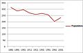 Population of Stanton over time.jpg 446 × 284; 22 KB
-
 Rhodes Cottage - geograph.org.uk - 223878.jpg 640 × 480; 117 KB
-
 Riding up Willridding Lane - geograph.org.uk - 5848450.jpg 1,306 × 979; 598 KB
-
 Rotting footbridge over Ordley Brook - geograph.org.uk - 5086461.jpg 1,280 × 960; 779 KB
-
 Slade Hollow - geograph.org.uk - 5008055.jpg 5,097 × 3,297; 1.52 MB
-
 Stanton - geograph.org.uk - 5008048.jpg 4,688 × 3,011; 1.77 MB
-
 Stanton - geograph.org.uk - 5008050.jpg 5,012 × 3,264; 1.91 MB
-
 Stanton - geograph.org.uk - 5008052.jpg 5,184 × 3,375; 1.98 MB
-
 Stanton Lane - geograph.org.uk - 5009142.jpg 5,184 × 3,456; 1.78 MB
-
 Stanton village pound^ - geograph.org.uk - 5848570.jpg 2,448 × 1,836; 1.99 MB
-
 Stile on a footpath at Ordley Bank - geograph.org.uk - 5086403.jpg 1,280 × 960; 785 KB
-
 Stone and timber stile - geograph.org.uk - 941241.jpg 480 × 640; 93 KB
-
 The coronation tree - geograph.org.uk - 5086424.jpg 1,280 × 960; 550 KB
-
 Thorswood Grange - geograph.org.uk - 5008062.jpg 4,406 × 3,224; 1.77 MB
-
 Thorswood Grange - geograph.org.uk - 5848616.jpg 1,373 × 1,030; 581 KB
-
 Thorswood House - geograph.org.uk - 5008056.jpg 5,170 × 2,257; 1.63 MB
-
 Thorswood House - geograph.org.uk - 5008060.jpg 4,583 × 2,628; 1.62 MB
-
 Thorswood House - geograph.org.uk - 5848607.jpg 2,684 × 1,798; 1.91 MB
-
 Thorswood House - geograph.org.uk - 941212.jpg 640 × 480; 57 KB
-
 Thorswood Lane - geograph.org.uk - 5009139.jpg 5,184 × 3,456; 2.02 MB
-
 View along Dale Lane - geograph.org.uk - 5848611.jpg 1,469 × 1,102; 421 KB
-
 Walls and barns in Stanton - geograph.org.uk - 5848537.jpg 2,122 × 1,591; 1.05 MB
-
 Willridding Lane south of Stanton - geograph.org.uk - 5848493.jpg 1,306 × 979; 692 KB
-
 Blakelow Lane - geograph.org.uk - 380319.jpg 640 × 480; 120 KB
-
 Stanton Chapel - geograph.org.uk - 223788.jpg 640 × 572; 57 KB
-
 Three Oaks Farm - geograph.org.uk - 223891.jpg 640 × 480; 105 KB


