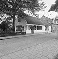
Category:Stichts End 4, Ankeveen
| Object location | | View all coordinates using: OpenStreetMap |
|---|
 | |||||
| Upload media | |||||
| Instance of | |||||
|---|---|---|---|---|---|
| Location | Ankeveen, North Holland, Netherlands | ||||
| Street address |
| ||||
| Located on street |
| ||||
| Heritage designation |
| ||||
 | |||||
|
This is a category about rijksmonument number 17392
|
| Address |
|
Media in category "Stichts End 4, Ankeveen"
The following 6 files are in this category, out of 6 total.
-
 17392 Tolhuis.jpg 3,000 × 2,000; 5.34 MB
-
 Gedeelte achtergevel - Ankeveen - 20022649 - RCE.jpg 1,192 × 1,200; 390 KB
-
 Linker zijgevel - Ankeveen - 20022648 - RCE.jpg 1,190 × 1,200; 273 KB
-
 MSD-20150405-327589.jpg 1,200 × 801; 346 KB
-
 Voor- en zijgevel - Ankeveen - 20022650 - RCE.jpg 1,188 × 1,200; 355 KB
-
 Voorgevel - Ankeveen - 20022647 - RCE.jpg 1,188 × 1,200; 318 KB


